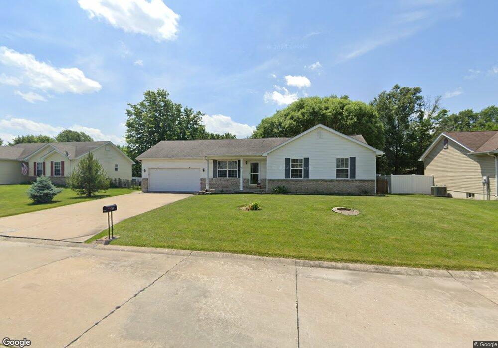
280 Derek Dr Hawk Point, MO 63349
Estimated Value: $197,000 - $241,000
3
Beds
2
Baths
1,164
Sq Ft
$193/Sq Ft
Est. Value
About This Home
This home is located at 280 Derek Dr, Hawk Point, MO 63349 and is currently estimated at $224,452, approximately $192 per square foot. 280 Derek Dr is a home located in Lincoln County with nearby schools including Hawk Point Elementary School, Troy Middle School, and Troy Buchanan High School.
Ownership History
Date
Name
Owned For
Owner Type
Purchase Details
Closed on
Jul 5, 2012
Sold by
Fannie Mae
Bought by
Morris Sharon
Current Estimated Value
Home Financials for this Owner
Home Financials are based on the most recent Mortgage that was taken out on this home.
Original Mortgage
$70,650
Outstanding Balance
$48,838
Interest Rate
3.7%
Mortgage Type
New Conventional
Estimated Equity
$175,614
Purchase Details
Closed on
Jun 14, 2012
Sold by
Green Tree Servicing Llc
Bought by
Federal National Mortgage Association
Home Financials for this Owner
Home Financials are based on the most recent Mortgage that was taken out on this home.
Original Mortgage
$70,650
Outstanding Balance
$48,838
Interest Rate
3.7%
Mortgage Type
New Conventional
Estimated Equity
$175,614
Purchase Details
Closed on
Mar 26, 2012
Sold by
Strunk Adam Michael and Strunk Meagan
Bought by
Green Tree Servicing Llc
Create a Home Valuation Report for This Property
The Home Valuation Report is an in-depth analysis detailing your home's value as well as a comparison with similar homes in the area
Purchase History
| Date | Buyer | Sale Price | Title Company |
|---|---|---|---|
| Morris Sharon | -- | None Available | |
| Federal National Mortgage Association | -- | None Available | |
| Green Tree Servicing Llc | $104,126 | None Available |
Source: Public Records
Mortgage History
| Date | Status | Borrower | Loan Amount |
|---|---|---|---|
| Open | Morris Sharon | $70,650 |
Source: Public Records
Tax History
| Year | Tax Paid | Tax Assessment Tax Assessment Total Assessment is a certain percentage of the fair market value that is determined by local assessors to be the total taxable value of land and additions on the property. | Land | Improvement |
|---|---|---|---|---|
| 2025 | $1,752 | $27,518 | $3,800 | $23,718 |
| 2024 | $1,627 | $25,093 | $2,850 | $22,243 |
| 2023 | $1,618 | $25,093 | $2,850 | $22,243 |
| 2022 | $1,536 | $23,984 | $2,850 | $21,134 |
| 2021 | $1,542 | $126,230 | $0 | $0 |
| 2020 | $1,328 | $109,780 | $0 | $0 |
| 2019 | $1,330 | $109,780 | $0 | $0 |
| 2018 | $1,371 | $21,242 | $0 | $0 |
| 2017 | $1,375 | $21,242 | $0 | $0 |
| 2016 | $1,279 | $19,285 | $0 | $0 |
| 2015 | $1,287 | $19,285 | $0 | $0 |
| 2014 | -- | $19,285 | $0 | $0 |
| 2013 | -- | $19,194 | $0 | $0 |
Source: Public Records
Map
Nearby Homes
- 415 Walnut St
- 4 Ashley Ln
- 8 Summers Breeze Ct
- 2 Country Ridge Trail
- 140 Turkey Creek Crossing Dr
- 339 White Rd
- 20 Chinkapin Ct
- 300 Shumard Oak Dr
- 346 Bethel Rd
- 161 Bethel Rd
- 804 Timber Creek Ct
- 401 Deep Forest Dr
- 113 Bridlespur Ct
- 64 Mocking Bird Ln
- 456 Westridge Dr
- 459 Westridge Dr
- 0 Cedar Circle Ln Unit MIS25071955
- 762 Cave Farm Rd
- 0 Westridge Dr
- 45 Blue Line Ln
Your Personal Tour Guide
Ask me questions while you tour the home.