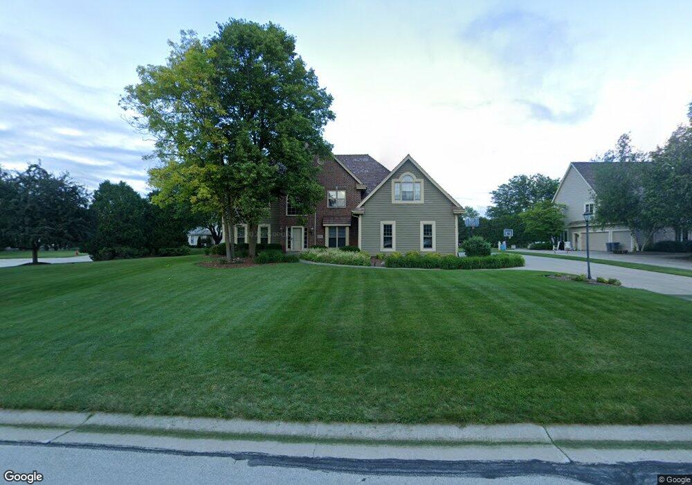
2810 Lancaster Ct Brookfield, WI 53045
Estimated Value: $888,000 - $961,000
4
Beds
5
Baths
3,300
Sq Ft
$282/Sq Ft
Est. Value
About This Home
This home is located at 2810 Lancaster Ct, Brookfield, WI 53045 and is currently estimated at $930,340, approximately $281 per square foot. 2810 Lancaster Ct is a home located in Waukesha County with nearby schools including Brookfield Elementary School, Wisconsin Hills Middle School, and Brookfield Central High School.
Ownership History
Date
Name
Owned For
Owner Type
Purchase Details
Closed on
Jan 27, 1997
Sold by
Harlan Joe E and Harlan Theresa
Bought by
Anderson Carl D and Anderson Kimberly A
Current Estimated Value
Home Financials for this Owner
Home Financials are based on the most recent Mortgage that was taken out on this home.
Original Mortgage
$305,000
Outstanding Balance
$35,072
Interest Rate
7.75%
Mortgage Type
Purchase Money Mortgage
Estimated Equity
$895,268
Purchase Details
Closed on
Dec 8, 1995
Sold by
Piccolo Joseph A and Piccolo Jane E
Bought by
Harlan Joe E and Harlan Theresa A
Home Financials for this Owner
Home Financials are based on the most recent Mortgage that was taken out on this home.
Original Mortgage
$340,000
Interest Rate
6.5%
Mortgage Type
Purchase Money Mortgage
Create a Home Valuation Report for This Property
The Home Valuation Report is an in-depth analysis detailing your home's value as well as a comparison with similar homes in the area
Home Values in the Area
Average Home Value in this Area
Purchase History
We collect this data history from publicly available records. To have your information removed, we recommend requesting removal directly through your county’s website.
| Date | Buyer | Sale Price | Title Company |
|---|---|---|---|
| Anderson Carl D | $389,000 | -- | |
| Harlan Joe E | $379,000 | -- |
Source: Public Records
Mortgage History
We collect this data history from publicly available records. To have your information removed, we recommend requesting removal directly through your county’s website.
| Date | Status | Borrower | Loan Amount |
|---|---|---|---|
| Open | Anderson Carl D | $305,000 | |
| Previous Owner | Harlan Joe E | $340,000 |
Source: Public Records
Tax History
| Year | Tax Paid | Tax Assessment Tax Assessment Total Assessment is a certain percentage of the fair market value that is determined by local assessors to be the total taxable value of land and additions on the property. | Land | Improvement |
|---|---|---|---|---|
| 2024 | $8,940 | $787,200 | $224,700 | $562,500 |
| 2023 | $8,960 | $787,200 | $224,700 | $562,500 |
| 2022 | $9,267 | $636,900 | $214,000 | $422,900 |
| 2021 | $9,826 | $636,900 | $214,000 | $422,900 |
| 2020 | $10,202 | $636,900 | $214,000 | $422,900 |
| 2019 | $9,817 | $636,900 | $214,000 | $422,900 |
| 2018 | $9,281 | $586,800 | $200,000 | $386,800 |
| 2017 | $9,255 | $586,800 | $200,000 | $386,800 |
| 2016 | $9,388 | $586,800 | $200,000 | $386,800 |
| 2015 | $9,325 | $586,800 | $200,000 | $386,800 |
| 2014 | $9,674 | $586,800 | $200,000 | $386,800 |
| 2013 | $9,674 | $586,800 | $200,000 | $386,800 |
Source: Public Records
Map
Nearby Homes
- 2820 Norman Dr
- 2840 Norman Dr
- Lt118 Berwick Ct
- Lt120 Berwick Ct
- Lt116 Berwick Ct
- Lt114 Berwick Ct
- 2850 Berwick Ct
- 21065 Bradford Ln
- 2550 Harmony Cir
- 21300 Astolat Dr
- 2490 de Carlin Dr
- 2320 Buckingham Place
- 20000 Glenoaks Dr
- 19065 N Hills Dr
- 18860 N Hills Dr
- N32W22121 Hill n Dale Cir
- 18830 Brookdale Dr
- 19775 Trilby Ct
- 21965 W North Ave
- 19475 Summerhill Ln
- 2790 Lancaster Ct
- 20635 Manchester Ct
- 2815 Lancaster Ct
- 20670 Manchester Ct
- 20630 Manchester Ct
- 2795 Lancaster Ct
- 2760 Lancaster Ct
- 2775 Spencer Ln
- 20545 Chadwick Ln
- 20720 Manchester Ct
- 2765 Lancaster Ct
- 20755 Manchester Ct
- 2745 Spencer Ln
- 20790 Bridgetown Ct
- 20650 Spencer Ct
- 20645 Chadwick Ln
- 20565 Chadwick Ln
- 20605 Chadwick Ln
- 20705 Chadwick Ln
- 20585 Chadwick Ln
Your Personal Tour Guide
Ask me questions while you tour the home.