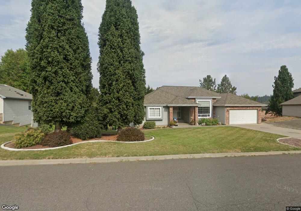
2811 E Snead Ave Spokane, WA 99223
Estimated Value: $511,498 - $577,000
3
Beds
2
Baths
1,790
Sq Ft
$305/Sq Ft
Est. Value
About This Home
This home is located at 2811 E Snead Ave, Spokane, WA 99223 and is currently estimated at $546,625, approximately $305 per square foot. 2811 E Snead Ave is a home located in Spokane County with nearby schools including Freeman Elementary School, Freeman Middle School, and Freeman High School.
Ownership History
Date
Name
Owned For
Owner Type
Purchase Details
Closed on
Feb 14, 1995
Sold by
Morss Anthony D and Morss Jeanne M
Bought by
Gilman Wayne H and Gilman Susan J
Current Estimated Value
Home Financials for this Owner
Home Financials are based on the most recent Mortgage that was taken out on this home.
Original Mortgage
$85,000
Interest Rate
9.27%
Create a Home Valuation Report for This Property
The Home Valuation Report is an in-depth analysis detailing your home's value as well as a comparison with similar homes in the area
Purchase History
| Date | Buyer | Sale Price | Title Company |
|---|---|---|---|
| Gilman Wayne H | -- | Transamerica Title |
Source: Public Records
Mortgage History
| Date | Status | Borrower | Loan Amount |
|---|---|---|---|
| Closed | Gilman Wayne H | $85,000 |
Source: Public Records
Tax History
| Year | Tax Paid | Tax Assessment Tax Assessment Total Assessment is a certain percentage of the fair market value that is determined by local assessors to be the total taxable value of land and additions on the property. | Land | Improvement |
|---|---|---|---|---|
| 2025 | $4,213 | $461,000 | $80,000 | $381,000 |
| 2024 | $4,213 | $445,300 | $85,000 | $360,300 |
| 2023 | $4,520 | $456,700 | $80,000 | $376,700 |
| 2022 | $4,359 | $456,700 | $80,000 | $376,700 |
| 2021 | $4,077 | $328,800 | $38,000 | $290,800 |
| 2020 | $3,904 | $298,300 | $32,500 | $265,800 |
| 2019 | $3,624 | $279,000 | $32,500 | $246,500 |
| 2018 | $3,255 | $235,900 | $32,500 | $203,400 |
| 2017 | $2,959 | $218,400 | $30,000 | $188,400 |
| 2016 | $3,002 | $212,500 | $30,000 | $182,500 |
| 2015 | $2,982 | $214,200 | $30,000 | $184,200 |
| 2014 | -- | $209,700 | $30,000 | $179,700 |
| 2013 | -- | $0 | $0 | $0 |
Source: Public Records
Map
Nearby Homes
- 11705 S Littler Dr
- 2707 E Player Dr
- 2120 E Turnberry Ln
- 12102 S Troon Ln
- 2102 E Dunbar Ln
- 11511 S Fairway Ridge Ln
- 1912 E Tomahawk Ln
- 1824 E Tomahawk Ln
- 11812 S Fairway Ridge Ln
- 11615 S Elk Run Ln
- 1610 E Eagle Feather Ln
- 12910 S Fairway Ridge Ln
- 2410 E Hangman Creek Ln
- 13110 S Fairway Ridge Ln
- 2206 E Pinehill Ln
- 13417 S Bluegrouse Ln
- 1607 E Wildflower Ln
- 1517 E Wildflower Ln
- 0 Nka East Hoffman Ln
- 11021 S Hatch Rd
- 2721 E Snead Ave
- 2919 E Snead Ave
- 11703 S Player Dr
- 11707 S Player Dr
- 2810 E Snead Ave
- 11621 S Player Dr
- 2713 E Snead Ave
- 11711 S Player Dr
- 2820 E Snead Ave
- 2724 E Snead Ave
- 11620 S Littler Dr
- 2619 E Snead Ave
- 11717 S Player Dr
- 11613 S Player Dr
- 11613 S Player Dr Unit 34
- 11614 S Littler Dr
- 2716 E Snead Ave
- 2815 E Player Dr
- 2821 E Player Dr
- 11702 S Player Dr
Your Personal Tour Guide
Ask me questions while you tour the home.