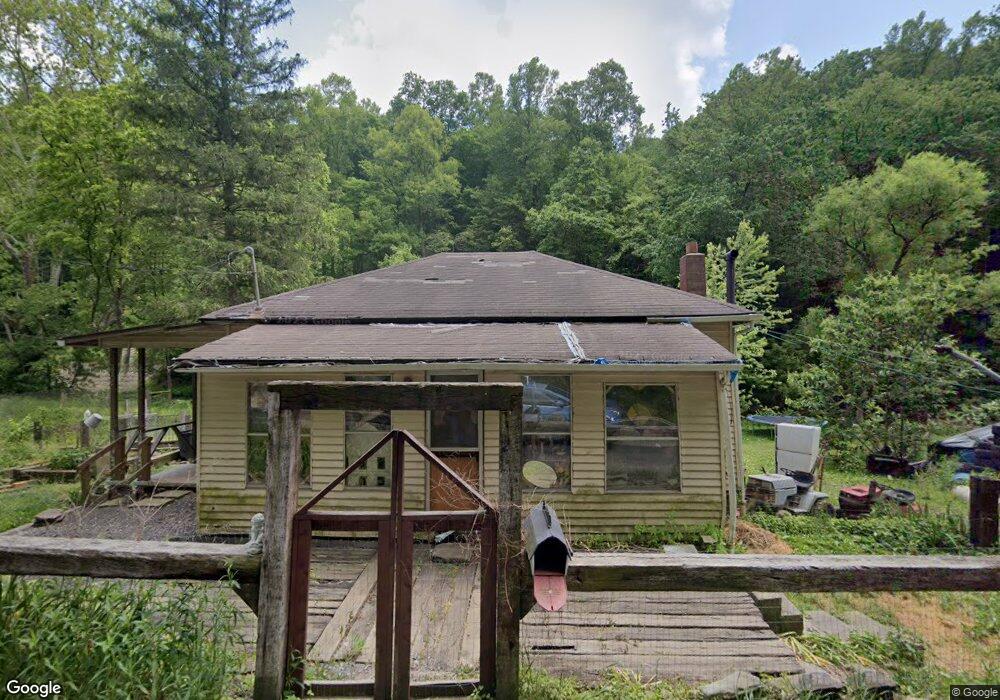
282 Deep Valley Rd Aleppo, PA 15310
Estimated Value: $58,000 - $152,000
1
Bed
1
Bath
690
Sq Ft
$136/Sq Ft
Est. Value
About This Home
This home is located at 282 Deep Valley Rd, Aleppo, PA 15310 and is currently estimated at $93,754, approximately $135 per square foot. 282 Deep Valley Rd is a home with nearby schools including West Greene High School.
Ownership History
Date
Name
Owned For
Owner Type
Purchase Details
Closed on
Jun 2, 2014
Sold by
Johnston Gerald E and Johnston Patricia I
Bought by
Roupe Donald L and Wood Jennifer R
Current Estimated Value
Home Financials for this Owner
Home Financials are based on the most recent Mortgage that was taken out on this home.
Original Mortgage
$30,100
Interest Rate
4.33%
Mortgage Type
Seller Take Back
Purchase Details
Closed on
Mar 25, 2005
Sold by
Vath William J and Vath Amanda R
Bought by
Johnston Gerald E and Johnston Patricia I
Create a Home Valuation Report for This Property
The Home Valuation Report is an in-depth analysis detailing your home's value as well as a comparison with similar homes in the area
Purchase History
| Date | Buyer | Sale Price | Title Company |
|---|---|---|---|
| Roupe Donald L | $30,100 | None Available | |
| Johnston Gerald E | $18,000 | None Available |
Source: Public Records
Mortgage History
| Date | Status | Borrower | Loan Amount |
|---|---|---|---|
| Closed | Roupe Donald L | $30,100 |
Source: Public Records
Tax History
| Year | Tax Paid | Tax Assessment Tax Assessment Total Assessment is a certain percentage of the fair market value that is determined by local assessors to be the total taxable value of land and additions on the property. | Land | Improvement |
|---|---|---|---|---|
| 2025 | $1,207 | $37,470 | $4,790 | $32,680 |
| 2024 | $1,198 | $37,470 | $4,790 | $32,680 |
| 2023 | $1,198 | $37,470 | $4,790 | $32,680 |
| 2022 | $1,198 | $37,470 | $4,790 | $32,680 |
| 2021 | $1,198 | $37,470 | $4,790 | $32,680 |
| 2020 | $1,125 | $36,880 | $4,790 | $32,090 |
| 2019 | $1,125 | $36,880 | $4,790 | $32,090 |
| 2018 | $11 | $36,880 | $4,790 | $32,090 |
| 2017 | $1,111 | $36,880 | $4,790 | $32,090 |
| 2016 | -- | $36,880 | $4,790 | $32,090 |
| 2015 | -- | $36,880 | $4,790 | $32,090 |
| 2014 | -- | $36,880 | $4,790 | $32,090 |
| 2013 | -- | $36,880 | $4,790 | $32,090 |
Source: Public Records
Map
Nearby Homes
- 0 Fall Run Rd
- 0 Knob Run Rd
- 191 Mount Carmel Ridge Rd
- 8698 Hornet Hwy
- 256 Browns Run Rd
- 962 Reid Ridge
- 104 Renner Creek Rd
- 808 Rush Run Rd
- 0 Mountaineer Hwy Unit 5190512
- 112 Pennsylvania Ave
- 10 Church St
- 0 Golden Oaks Rd Unit 26400158
- 0 Golden Oaks Rd Unit 11659446
- 0 Low Gap Run Rd
- 241 Robinson Ridge Rd
- 1742 Rush Run Rd
- 14451 Proctor Creek Rd
- 0 Pyles Fork Rd
- 16240 Fish Creek Rd
- 52 County Highway 250 4
Your Personal Tour Guide
Ask me questions while you tour the home.