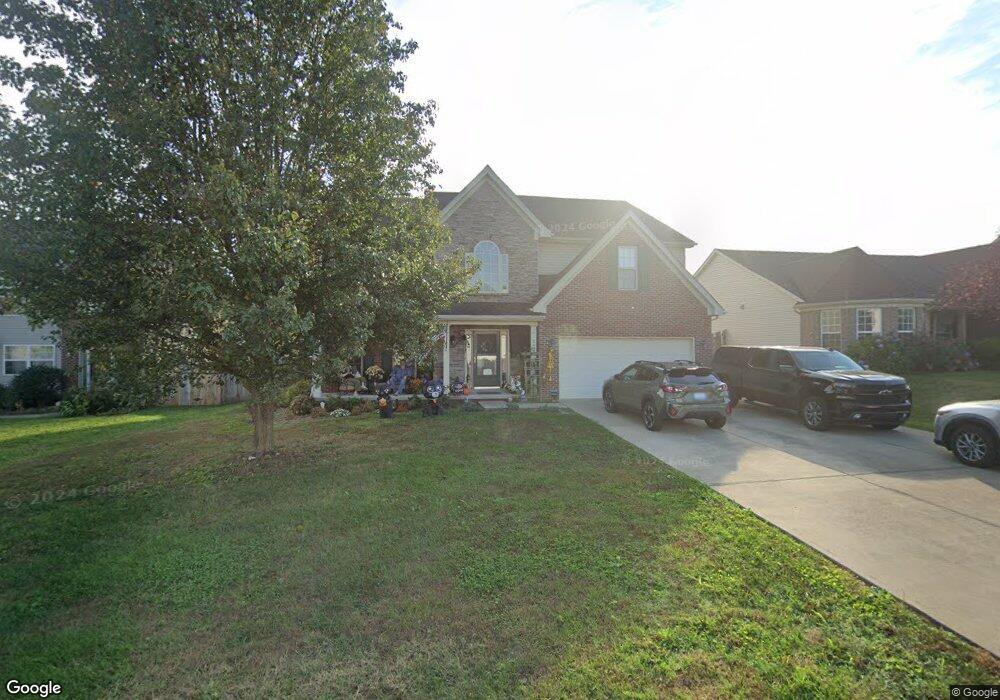
283 Ransom Trace Georgetown, KY 40324
Bradford Place NeighborhoodEstimated Value: $382,000 - $395,000
4
Beds
3
Baths
2,576
Sq Ft
$151/Sq Ft
Est. Value
About This Home
This home is located at 283 Ransom Trace, Georgetown, KY 40324 and is currently estimated at $389,221, approximately $151 per square foot. 283 Ransom Trace is a home located in Scott County with nearby schools including Southern Elementary School, Georgetown Middle School, and Scott County High School.
Ownership History
Date
Name
Owned For
Owner Type
Purchase Details
Closed on
Jul 30, 2007
Sold by
Ball Homes Llc
Bought by
Jackson Kevin C and Jackson Tia M
Current Estimated Value
Home Financials for this Owner
Home Financials are based on the most recent Mortgage that was taken out on this home.
Original Mortgage
$178,513
Outstanding Balance
$110,754
Interest Rate
6.63%
Mortgage Type
New Conventional
Estimated Equity
$278,467
Create a Home Valuation Report for This Property
The Home Valuation Report is an in-depth analysis detailing your home's value as well as a comparison with similar homes in the area
Home Values in the Area
Average Home Value in this Area
Purchase History
We collect this data history from publicly available records. To have your information removed, we recommend requesting removal directly through your county’s website.
| Date | Buyer | Sale Price | Title Company |
|---|---|---|---|
| Jackson Kevin C | $210,016 | None Available |
Source: Public Records
Mortgage History
We collect this data history from publicly available records. To have your information removed, we recommend requesting removal directly through your county’s website.
| Date | Status | Borrower | Loan Amount |
|---|---|---|---|
| Open | Jackson Kevin C | $178,513 |
Source: Public Records
Tax History
| Year | Tax Paid | Tax Assessment Tax Assessment Total Assessment is a certain percentage of the fair market value that is determined by local assessors to be the total taxable value of land and additions on the property. | Land | Improvement |
|---|---|---|---|---|
| 2025 | $3,076 | $345,300 | $0 | $0 |
| 2024 | $2,866 | $318,700 | $0 | $0 |
| 2023 | $2,745 | $302,800 | $42,000 | $260,800 |
| 2022 | $2,071 | $243,600 | $35,000 | $208,600 |
| 2021 | $2,122 | $225,300 | $35,000 | $190,300 |
| 2020 | $1,823 | $212,200 | $35,000 | $177,200 |
| 2019 | $1,763 | $202,000 | $0 | $0 |
| 2018 | $1,708 | $196,780 | $0 | $0 |
| 2017 | $1,716 | $196,780 | $0 | $0 |
| 2016 | $1,584 | $196,780 | $0 | $0 |
| 2015 | $1,555 | $194,300 | $0 | $0 |
| 2014 | $1,611 | $194,300 | $0 | $0 |
| 2011 | $126 | $203,400 | $0 | $0 |
Source: Public Records
Map
Nearby Homes
- 250 Ransom Trace
- 125 Emerson Trail
- 216 Redding Rd
- 113 Emerson Trail
- 217 Redding Rd
- 198 Ransom Trace
- 112 Redding Lake Cir
- 115 Victor Place
- 402 Hiawatha Trail
- 253 W Showalter Dr
- 105 Bronte Place
- 118 Ransom Trace
- 135 W Chopin Way
- 106 Cabot Place
- 106 Chloe Ct Unit 2
- 1018 Parkside Dr
- 106 Capella Way
- 107 Hillside Dr
- 110 Capella Way
- 132 Magellan Ln
- 285 Ransom Trace
- 281 Ransom Trace Unit 3H
- 112 Walden Cove Unit 3I
- 114 Walden Cove
- 110 Walden Cove
- 287 Ransom Trace
- 274 Ransom Trace Unit 3H
- 279 Ransom Trace
- 108 Walden Cove
- 277 Ransom Trace
- 116 Walden Cove
- 100 Ellen Ct
- 289 Ransom Trace
- 275 Ransom Trace
- 272 Ransom Trace
- 106 Walden Cove
- 273 Ransom Trace
- 102 Ellen Ct
- 119 Walden Cove
- 291 Ransom Trace
Your Personal Tour Guide
Ask me questions while you tour the home.