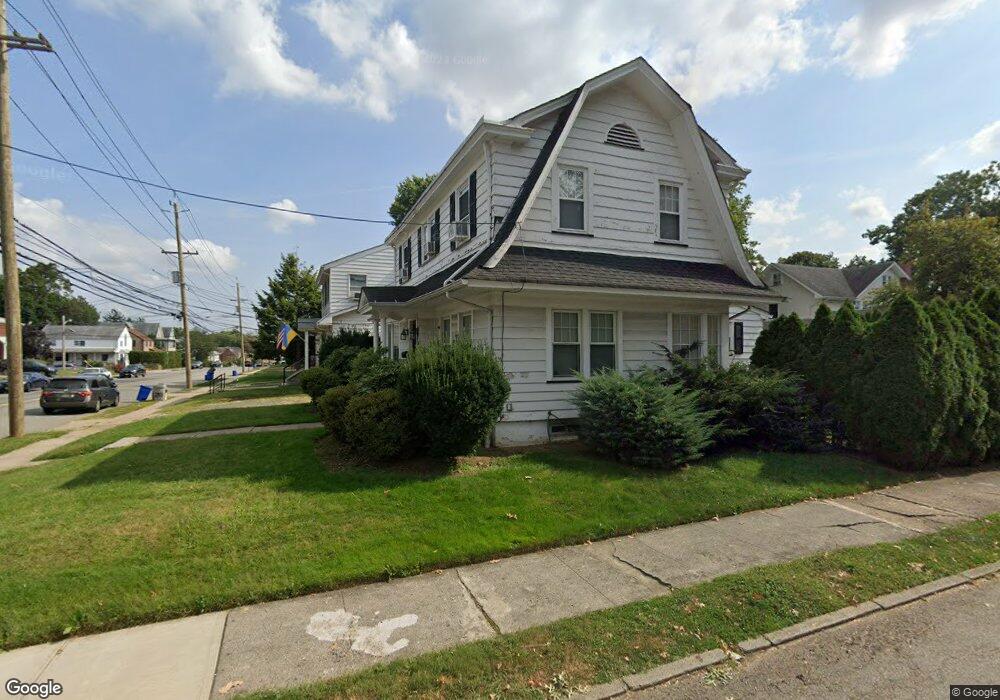
285 Brook Ave Passaic, NJ 07055
Estimated Value: $609,330 - $743,000
About This Home
This home is located at 285 Brook Ave, Passaic, NJ 07055 and is currently estimated at $671,583, approximately $426 per square foot. 285 Brook Ave is a home located in Passaic County with nearby schools including Passaic High School # 12, Yeshiva Ktana Of Passaic Boys, and Collegiate School.
Ownership History
We collect this data history from publicly available records. To have your information removed, we recommend requesting removal directly through your county’s website.
Purchase Details
Home Financials for this Owner
Home Financials are based on the most recent Mortgage that was taken out on this home.Purchase Details
Home Financials for this Owner
Home Financials are based on the most recent Mortgage that was taken out on this home.Home Values in the Area
Average Home Value in this Area
Purchase History
We collect this data history from publicly available records. To have your information removed, we recommend requesting removal directly through your county’s website.
| Date | Buyer | Sale Price | Title Company |
|---|---|---|---|
| $419,000 | -- | ||
| $150,000 | -- |
Mortgage History
We collect this data history from publicly available records. To have your information removed, we recommend requesting removal directly through your county’s website.
| Date | Status | Borrower | Loan Amount |
|---|---|---|---|
| Open | $334,000 | ||
| Previous Owner | $125,000 |
Tax History
We collect this data history from publicly available records. To have your information removed, we recommend requesting removal directly through your county’s website.
| Year | Tax Paid | Tax Assessment Tax Assessment Total Assessment is a certain percentage of the fair market value that is determined by local assessors to be the total taxable value of land and additions on the property. | Land | Improvement |
|---|---|---|---|---|
| 2025 | $11,928 | $289,300 | $159,600 | $129,700 |
| 2024 | $11,584 | $289,300 | $159,600 | $129,700 |
| 2022 | $11,236 | $289,300 | $159,600 | $129,700 |
| 2021 | $10,878 | $289,300 | $159,600 | $129,700 |
| 2020 | $10,794 | $289,300 | $159,600 | $129,700 |
| 2019 | $10,638 | $289,300 | $159,600 | $129,700 |
| 2018 | $10,409 | $289,300 | $159,600 | $129,700 |
| 2017 | $10,088 | $289,300 | $159,600 | $129,700 |
| 2016 | $9,744 | $289,300 | $159,600 | $129,700 |
| 2015 | $10,898 | $143,900 | $60,200 | $83,700 |
| 2014 | $10,698 | $143,900 | $60,200 | $83,700 |
Map
- 334 Brook Ave
- 15 John St
- 145 Elmwood Ave
- 403 South Pkwy
- 360 Rutherford Blvd
- 412 Fenlon Blvd
- 86 Crescent Ave
- 101 Reid Ave
- 49 Bond St
- 178 Marietta Ave
- 440 Brook Ave
- 20 Bond St
- 38 Stewart St
- 14 Laurel Ave
- 129 Howard Ave
- 3 Juniper Ct Unit 123
- 142 Main Ave Unit 1c
- 142-148 Main Ave Unit C
- 53 Patricia Place
- 55 Heights Rd
Ask me questions while you tour the home.