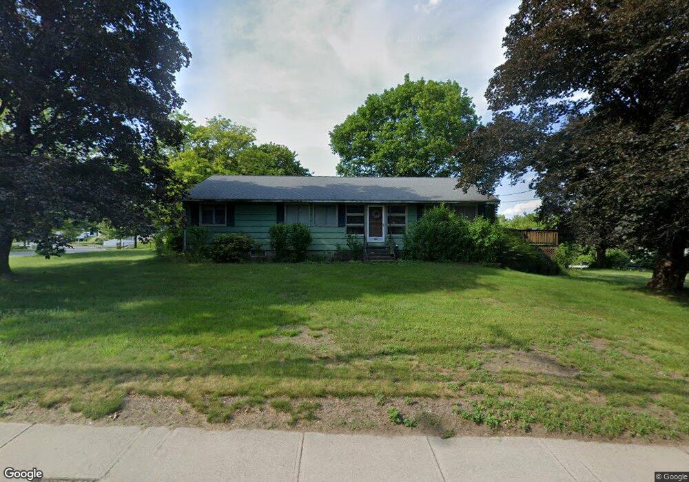
287 Pelham St Methuen, MA 01844
The West End NeighborhoodEstimated Value: $640,000 - $664,000
3
Beds
2
Baths
1,792
Sq Ft
$362/Sq Ft
Est. Value
About This Home
This home is located at 287 Pelham St, Methuen, MA 01844 and is currently estimated at $648,253, approximately $361 per square foot. 287 Pelham St is a home located in Essex County with nearby schools including Marsh Grammar School, Methuen High School, and Fellowship Christian Academy.
Ownership History
Date
Name
Owned For
Owner Type
Purchase Details
Closed on
Jun 14, 2010
Sold by
Nelson Dorothy E
Bought by
Raf Rt and Fluet
Current Estimated Value
Create a Home Valuation Report for This Property
The Home Valuation Report is an in-depth analysis detailing your home's value as well as a comparison with similar homes in the area
Home Values in the Area
Average Home Value in this Area
Purchase History
We collect this data history from publicly available records. To have your information removed, we recommend requesting removal directly through your county’s website.
| Date | Buyer | Sale Price | Title Company |
|---|---|---|---|
| Raf Rt | $500,000 | -- | |
| Raf Rt | $500,000 | -- |
Source: Public Records
Mortgage History
We collect this data history from publicly available records. To have your information removed, we recommend requesting removal directly through your county’s website.
| Date | Status | Borrower | Loan Amount |
|---|---|---|---|
| Open | Raf Rt | $241,851 | |
| Closed | Raf Rt | $250,000 |
Source: Public Records
Tax History
| Year | Tax Paid | Tax Assessment Tax Assessment Total Assessment is a certain percentage of the fair market value that is determined by local assessors to be the total taxable value of land and additions on the property. | Land | Improvement |
|---|---|---|---|---|
| 2025 | $5,869 | $554,700 | $272,300 | $282,400 |
| 2024 | $5,652 | $520,400 | $238,000 | $282,400 |
| 2023 | $5,355 | $457,700 | $209,400 | $248,300 |
| 2022 | $5,109 | $391,500 | $171,400 | $220,100 |
| 2021 | $4,796 | $363,600 | $161,800 | $201,800 |
| 2020 | $4,793 | $356,600 | $161,800 | $194,800 |
| 2019 | $4,589 | $323,400 | $152,300 | $171,100 |
| 2018 | $4,364 | $305,800 | $142,800 | $163,000 |
| 2017 | $4,253 | $290,300 | $142,800 | $147,500 |
| 2016 | $4,053 | $273,700 | $133,300 | $140,400 |
| 2015 | $3,917 | $268,300 | $133,300 | $135,000 |
Source: Public Records
Map
Nearby Homes
- 3 College Ln
- 40 Hillcrest Ave
- 34 Venice Rd
- 35 Canobieola Rd
- 3 Avalon Ct
- 2 Canobieola Rd
- 1 Silver Brook Rd
- 35 Ponderosa Ave
- 21 Hampshire Rd Unit 306
- 23 Hampshire Rd Unit 112
- 8 Carmel Rd
- 0 Hampshire Rd
- 26 Lamplighter Ln
- 95 Pelham St Unit 3
- 3 Cortland Dr
- 37 Brady Ave
- 3 Surrey Ln
- 298 Salem Rd
- 302 Salem Rd
- 16 Newhill Rd
- 2 Blueberry Ln
- 6 Blueberry Ln
- 1 Blueberry Ln
- 1 Ricks Way
- 287 Pelham St Unit 1
- 10 Blueberry Ln
- 0 Blueberry Ln Unit 70630379
- 0 Blueberry Ln Unit 70623571
- 0 Blueberry Ln Unit 70613347
- 0 Blueberry Ln Unit 70572830
- 0 Blueberry Ln Unit 70520642
- 0 Blueberry Ln Unit 70319207
- 0 Blueberry Ln Unit 70154156
- 0 Blueberry Ln Unit 1B
- 0 Blueberry Ln Unit 70224822
- 0 Blueberry Ln
- 15 Blueberry Ln
- 9 Blueberry Ln
- 19 Blueberry Ln
- 5 Blueberry Ln
Your Personal Tour Guide
Ask me questions while you tour the home.