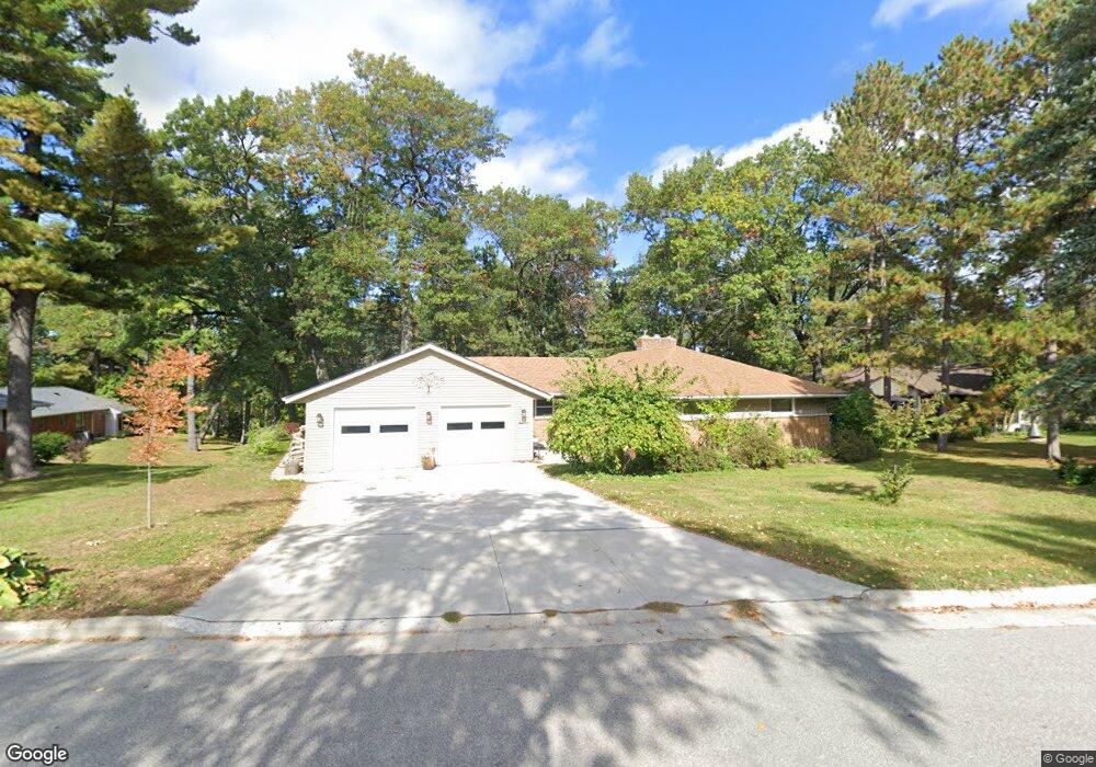
2891 Mount Carol Dr Green Bay, WI 54311
Schmitt Park NeighborhoodEstimated Value: $300,000 - $351,000
3
Beds
2
Baths
1,663
Sq Ft
$196/Sq Ft
Est. Value
About This Home
This home is located at 2891 Mount Carol Dr, Green Bay, WI 54311 and is currently estimated at $325,230, approximately $195 per square foot. 2891 Mount Carol Dr is a home located in Brown County with nearby schools including Baird Elementary School, Red Smith School, and Preble High School.
Ownership History
Date
Name
Owned For
Owner Type
Purchase Details
Closed on
Aug 8, 2013
Sold by
Tesar Lorraine E
Bought by
Moody Robert and Moody Lorraine E
Current Estimated Value
Home Financials for this Owner
Home Financials are based on the most recent Mortgage that was taken out on this home.
Original Mortgage
$84,000
Outstanding Balance
$17,387
Interest Rate
4.25%
Mortgage Type
New Conventional
Estimated Equity
$307,843
Purchase Details
Closed on
Jun 18, 1998
Sold by
Carroll Michael J
Bought by
Tesar Lorraine E
Home Financials for this Owner
Home Financials are based on the most recent Mortgage that was taken out on this home.
Original Mortgage
$99,900
Interest Rate
6.87%
Purchase Details
Closed on
May 21, 1998
Sold by
Carroll Mi Hyon
Bought by
Carroll Michael J
Home Financials for this Owner
Home Financials are based on the most recent Mortgage that was taken out on this home.
Original Mortgage
$99,900
Interest Rate
6.87%
Create a Home Valuation Report for This Property
The Home Valuation Report is an in-depth analysis detailing your home's value as well as a comparison with similar homes in the area
Home Values in the Area
Average Home Value in this Area
Purchase History
| Date | Buyer | Sale Price | Title Company |
|---|---|---|---|
| Moody Robert | -- | Title Trends | |
| Tesar Lorraine E | $111,000 | -- | |
| Carroll Michael J | -- | -- |
Source: Public Records
Mortgage History
| Date | Status | Borrower | Loan Amount |
|---|---|---|---|
| Open | Moody Robert | $84,000 | |
| Previous Owner | Tesar Lorraine E | $99,900 |
Source: Public Records
Tax History
| Year | Tax Paid | Tax Assessment Tax Assessment Total Assessment is a certain percentage of the fair market value that is determined by local assessors to be the total taxable value of land and additions on the property. | Land | Improvement |
|---|---|---|---|---|
| 2025 | $4,743 | $240,400 | $43,700 | $196,700 |
| 2024 | $4,707 | $240,400 | $43,700 | $196,700 |
| 2023 | $4,552 | $240,400 | $43,700 | $196,700 |
| 2022 | $4,553 | $240,400 | $43,700 | $196,700 |
| 2021 | $3,803 | $158,100 | $35,900 | $122,200 |
| 2020 | $4,044 | $158,100 | $35,900 | $122,200 |
| 2019 | $4,217 | $158,100 | $35,900 | $122,200 |
| 2018 | $3,687 | $149,600 | $35,900 | $113,700 |
| 2017 | $3,932 | $149,600 | $35,900 | $113,700 |
| 2016 | $3,610 | $149,600 | $35,900 | $113,700 |
| 2015 | $3,405 | $149,600 | $35,900 | $113,700 |
| 2014 | $3,363 | $149,600 | $35,900 | $113,700 |
| 2013 | $3,363 | $149,600 | $35,900 | $113,700 |
Source: Public Records
Map
Nearby Homes
- 1023 Laverne Dr
- 716 Mount Mary Dr
- 2735 University Ave
- 2964 Mossy Oak Cir Unit C1
- 2686 Humboldt Rd Unit 1
- 3012 Lawndale Dr
- 2672 Humboldt Rd Unit 4
- 359 van Caster Dr
- 3165 Humboldt Rd
- 3128 Concordia Ln
- 2500 University Ave
- 2592 Remington Ct
- 2517 Remington Rd
- 2503 Remington Rd
- 272 Lost Ridge Ct
- 1115 Bay Mist Dr
- 2640 Appian Way
- 1104 Bay Mist Dr
- 1101 Branigan Way
- 3329 Largo Ridge Dr
- 949 Saint Lawrence Dr
- 2871 Mount Carol Dr
- 991 Saint Lawrence Dr
- 950 Queoff St
- 2884 Mount Carol Dr
- 2892 Mount Carol Dr
- 1019 Saint Lawrence Dr
- 2872 Mount Carol Dr
- 2898 Mount Carol Dr
- 958 Saint Lawrence Dr
- 986 Saint Lawrence Dr
- 2919 Mount Carol Dr
- 2868 Mount Carol Dr
- 2855 Mount Carol Dr
- 1047 Saint Lawrence Dr
- 1016 Saint Lawrence Dr
- 1010 Queoff St
- 2859 Saint Ann Dr
- 2867 Saint Ann Dr
- 2857 Saint Ann Dr
Your Personal Tour Guide
Ask me questions while you tour the home.