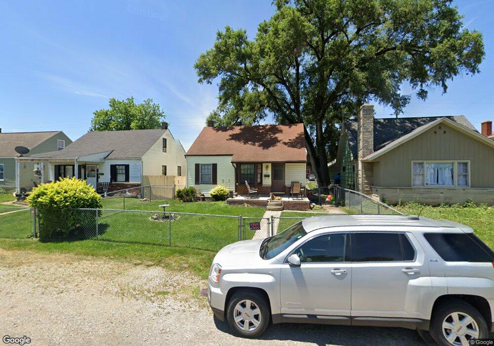
29 Coolidge Ave Columbus, OH 43228
Estimated Value: $148,000 - $160,152
3
Beds
1
Bath
1,098
Sq Ft
$141/Sq Ft
Est. Value
About This Home
This home is located at 29 Coolidge Ave, Columbus, OH 43228 and is currently estimated at $154,288, approximately $140 per square foot. 29 Coolidge Ave is a home located in Franklin County with nearby schools including Prairie Lincoln Elementary School, Galloway Ridge Intermediate School, and Norton Middle School.
Ownership History
Date
Name
Owned For
Owner Type
Purchase Details
Closed on
Nov 3, 1999
Sold by
Shepherd Deborah K and Wilcoxson Deborah K
Bought by
Shepherd Thomas and Shepherd Deborah K
Current Estimated Value
Home Financials for this Owner
Home Financials are based on the most recent Mortgage that was taken out on this home.
Original Mortgage
$49,400
Outstanding Balance
$18,396
Interest Rate
11.75%
Estimated Equity
$135,892
Purchase Details
Closed on
Sep 22, 1992
Bought by
Shepherd Deborah K
Purchase Details
Closed on
Apr 1, 1978
Create a Home Valuation Report for This Property
The Home Valuation Report is an in-depth analysis detailing your home's value as well as a comparison with similar homes in the area
Home Values in the Area
Average Home Value in this Area
Purchase History
| Date | Buyer | Sale Price | Title Company |
|---|---|---|---|
| Shepherd Thomas | -- | Tower City Title Agency Inc | |
| Shepherd Deborah K | -- | -- | |
| -- | $24,900 | -- |
Source: Public Records
Mortgage History
| Date | Status | Borrower | Loan Amount |
|---|---|---|---|
| Open | Shepherd Thomas | $49,400 |
Source: Public Records
Tax History
| Year | Tax Paid | Tax Assessment Tax Assessment Total Assessment is a certain percentage of the fair market value that is determined by local assessors to be the total taxable value of land and additions on the property. | Land | Improvement |
|---|---|---|---|---|
| 2025 | $2,396 | $46,980 | $8,510 | $38,470 |
| 2024 | $2,396 | $46,980 | $8,510 | $38,470 |
| 2023 | $2,383 | $46,970 | $8,505 | $38,465 |
| 2022 | $1,640 | $22,230 | $6,970 | $15,260 |
| 2021 | $1,558 | $22,230 | $6,970 | $15,260 |
| 2020 | $1,555 | $22,230 | $6,970 | $15,260 |
| 2019 | $1,369 | $17,540 | $6,060 | $11,480 |
| 2018 | $1,479 | $17,540 | $6,060 | $11,480 |
| 2017 | $1,536 | $17,540 | $6,060 | $11,480 |
| 2016 | $1,717 | $20,830 | $4,450 | $16,380 |
| 2015 | $1,594 | $20,830 | $4,450 | $16,380 |
| 2014 | $1,595 | $20,830 | $4,450 | $16,380 |
| 2013 | $870 | $23,135 | $4,935 | $18,200 |
Source: Public Records
Map
Nearby Homes
- 46 Florence Ave
- 277 Josephine Ave
- 139 Demorest Ave
- 281 Demorest Rd
- 121 S Southampton Ave
- 188 S Southampton Ave
- 415 Georgesville Rd
- 4006 Halsey Place
- 109 S Westgate Ave
- 3851 Fairmoor Rd
- 0 S Brinker Ave
- 3866 Eakin Rd
- 693 Maurine Dr
- 312 S Brinker Ave
- 361 N Algonquin Ave
- 3276 Sullivant Ave Unit 278
- 75 N Huron Ave
- 0 Fisher Rd
- 695 Demorest Rd
- 160 S Huron Ave
- 23 Coolidge Ave
- 35 Coolidge Ave
- 39 Coolidge Ave
- 45 Coolidge Ave
- 32 Viotis Dr
- 2789 U S Highway 40
- 3741 W Broad St
- 51 Coolidge Ave
- 2863 U S Highway 40
- 36 Viotis Dr
- 3765 W Broad St
- 30 Coolidge Ave
- 24 Coolidge Ave
- 36 Coolidge Ave
- 55 Coolidge Ave
- 54 Viotis Dr
- 40 Coolidge Ave
- 34 Viotis Dr
- 3705 W Broad St
- 3705 W Broad St
Your Personal Tour Guide
Ask me questions while you tour the home.