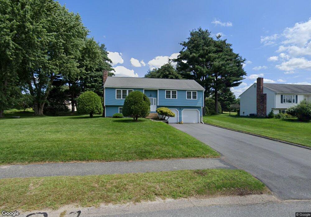
29 Tomahawk Dr Northborough, MA 01532
Estimated Value: $648,507 - $743,000
About This Home
This home is located at 29 Tomahawk Dr, Northborough, MA 01532 and is currently estimated at $688,377, approximately $537 per square foot. 29 Tomahawk Dr is a home located in Worcester County with nearby schools including Fannie E. Proctor Elementary School, Robert E. Melican Middle School, and Algonquin Regional High School.
Ownership History
We collect this data history from publicly available records. To have your information removed, we recommend requesting removal directly through your county’s website.
Purchase Details
Home Values in the Area
Average Home Value in this Area
Purchase History
We collect this data history from publicly available records. To have your information removed, we recommend requesting removal directly through your county’s website.
| Date | Buyer | Sale Price | Title Company |
|---|---|---|---|
| $88,900 | -- |
Mortgage History
We collect this data history from publicly available records. To have your information removed, we recommend requesting removal directly through your county’s website.
| Date | Status | Borrower | Loan Amount |
|---|---|---|---|
| Closed | $0 |
Tax History
We collect this data history from publicly available records. To have your information removed, we recommend requesting removal directly through your county’s website.
| Year | Tax Paid | Tax Assessment Tax Assessment Total Assessment is a certain percentage of the fair market value that is determined by local assessors to be the total taxable value of land and additions on the property. | Land | Improvement |
|---|---|---|---|---|
| 2025 | $8,539 | $599,200 | $297,400 | $301,800 |
| 2024 | $7,577 | $530,600 | $237,400 | $293,200 |
| 2023 | $7,423 | $501,900 | $223,800 | $278,100 |
| 2022 | $7,213 | $437,400 | $213,300 | $224,100 |
| 2021 | $6,915 | $403,900 | $194,000 | $209,900 |
| 2020 | $6,771 | $392,500 | $183,100 | $209,400 |
| 2019 | $6,587 | $384,100 | $177,800 | $206,300 |
| 2018 | $6,266 | $360,300 | $173,700 | $186,600 |
| 2017 | $6,097 | $350,600 | $173,700 | $176,900 |
| 2016 | $5,745 | $334,600 | $170,300 | $164,300 |
| 2015 | $5,359 | $320,300 | $178,400 | $141,900 |
| 2014 | $5,171 | $311,700 | $178,400 | $133,300 |
Map
- 33 Tomahawk Dr
- 6 Thayer St
- 15 Lanthorn Rd
- 49 Hamilton Rd
- 6 Hillside Rd
- 14 Hillside Rd
- 117 Madison Rd
- 9 Powder Hill Way Unit 9
- 5 Hawthorne Cir
- 104 SW Cutoff
- 9 Eliot Rd
- 31 Jefferson Rd
- 19 Jefferson Rd
- 60 Northgate Rd
- 18 Mayflower Rd
- 25 Intervale Farm Ln
- 149 Milk St Unit 20
- 2106 Simeon Howard Way Unit 2106
- 57 Townsend Blvd
- 165 South St
- 22 Tomahawk Dr
- 18 Tomahawk Dr
- 26 Tomahawk Dr
- 30 Tomahawk Dr
- 14 Tomahawk Dr
- 142 Indian Meadow Dr
- 138 Indian Meadow Dr
- 134 Indian Meadow Dr
- 146 Indian Meadow Dr
- 25 Tomahawk Dr
- 21 Tomahawk Dr
- 130 Indian Meadow Dr
- 10 Tomahawk Dr
- 150 Indian Meadow Dr
- 17 Tomahawk Dr
- 166 Indian Meadow Dr
- 174 Indian Meadow Dr
- 34 Tomahawk Dr
- 126 Indian Meadow Dr
- 158 Indian Meadow Dr
Ask me questions while you tour the home.