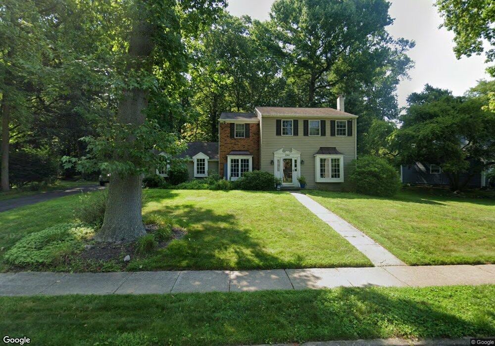
290 Forrest Rd Yardley, PA 19067
Estimated Value: $718,969 - $818,000
4
Beds
3
Baths
2,449
Sq Ft
$316/Sq Ft
Est. Value
About This Home
This home is located at 290 Forrest Rd, Yardley, PA 19067 and is currently estimated at $773,992, approximately $316 per square foot. 290 Forrest Rd is a home located in Bucks County with nearby schools including Makefield Elementary School, William Penn Middle School, and Pennsbury High School.
Ownership History
Date
Name
Owned For
Owner Type
Purchase Details
Closed on
Feb 28, 1994
Sold by
Gannaway David J and Gannaway Theresa A
Bought by
Goode Daniel J and Goode Cynthia E
Current Estimated Value
Home Financials for this Owner
Home Financials are based on the most recent Mortgage that was taken out on this home.
Original Mortgage
$201,000
Interest Rate
6.93%
Purchase Details
Closed on
Sep 8, 1987
Bought by
Gannaway David J and Gannaway Theresa A
Create a Home Valuation Report for This Property
The Home Valuation Report is an in-depth analysis detailing your home's value as well as a comparison with similar homes in the area
Home Values in the Area
Average Home Value in this Area
Purchase History
| Date | Buyer | Sale Price | Title Company |
|---|---|---|---|
| Goode Daniel J | $225,500 | -- | |
| Gannaway David J | $268,000 | -- |
Source: Public Records
Mortgage History
| Date | Status | Borrower | Loan Amount |
|---|---|---|---|
| Closed | Goode Daniel J | $201,000 |
Source: Public Records
Tax History
| Year | Tax Paid | Tax Assessment Tax Assessment Total Assessment is a certain percentage of the fair market value that is determined by local assessors to be the total taxable value of land and additions on the property. | Land | Improvement |
|---|---|---|---|---|
| 2025 | $10,075 | $42,550 | $11,000 | $31,550 |
| 2024 | $10,075 | $42,550 | $11,000 | $31,550 |
| 2023 | $9,570 | $42,550 | $11,000 | $31,550 |
| 2022 | $9,362 | $42,550 | $11,000 | $31,550 |
| 2021 | $9,214 | $42,550 | $11,000 | $31,550 |
| 2020 | $9,214 | $42,550 | $11,000 | $31,550 |
| 2019 | $9,031 | $42,550 | $11,000 | $31,550 |
| 2018 | $8,873 | $42,550 | $11,000 | $31,550 |
| 2017 | $8,598 | $42,550 | $11,000 | $31,550 |
| 2016 | $8,498 | $42,550 | $11,000 | $31,550 |
| 2015 | -- | $42,550 | $11,000 | $31,550 |
| 2014 | -- | $42,550 | $11,000 | $31,550 |
Source: Public Records
Map
Nearby Homes
- 300 Robin Hood Dr
- 65 Sutphin Pines
- 205 Marlboro Rd
- 18 Sutphin Pines
- 58 Sutphin Pnes Pines
- 221 Valley Dr
- 642 Friar Dr
- 477 Keating Dr
- 50 Sutphin Rd
- 8 Moon Cir
- 695 Friar Dr
- 502 Stevens Rd
- 108 Glen Valley Rd
- 222 Arborlea Ave
- 1608 S Crescent Blvd
- 1802 Yardley Morrisville Rd
- 5 Saint James Place
- 24 Valley View Dr
- 1465 Makefield Rd
- 207 W Ferry Rd
- 286 Forrest Rd
- 294 Forrest Rd
- 280 Forrest Rd
- 292 Sherwood Dr
- 293 Forrest Rd
- 551 Nottingham Dr
- 274 Forrest Rd
- 287 Forrest Rd
- 298 Sherwood Dr
- 293 Sherwood Dr
- 281 Forrest Rd
- 543 Nottingham Dr
- 573 Nottingham Dr
- 268 Forrest Rd
- 306 Sherwood Dr
- 275 Forrest Rd
- 299 Sherwood Dr
- 534 Nottingham Dr
- 528 Nottingham Dr
- 269 Forrest Rd
Your Personal Tour Guide
Ask me questions while you tour the home.