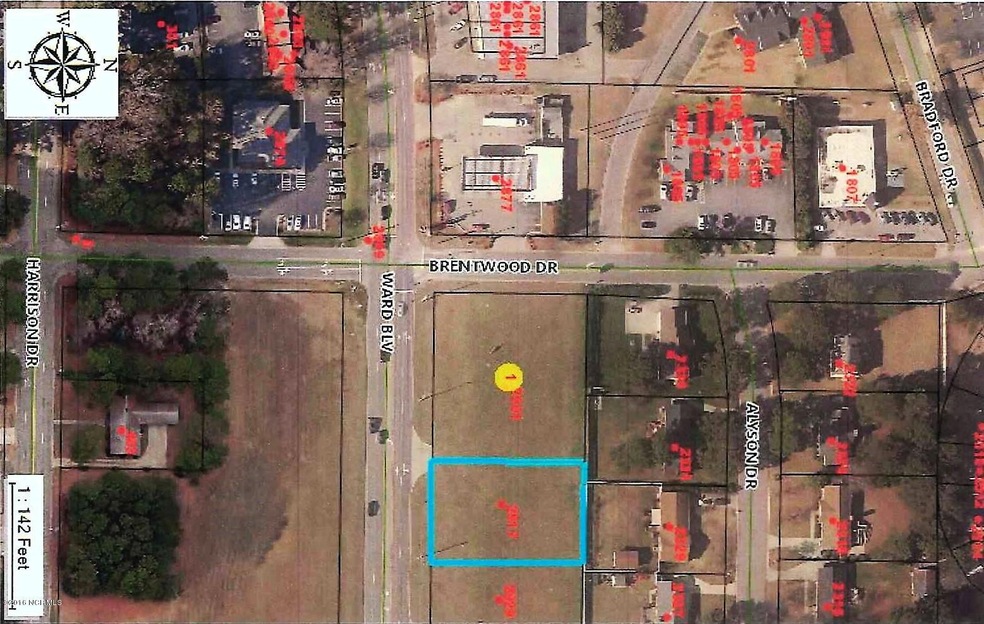
2917 Ward Blvd Wilson, NC 27893
Estimated payment $637/month
About This Lot
OFFICE USE ZONED RMX. LISTING AGENT IS OWNER.
Property Details
Property Type
- Land
Lot Details
- 19,665 Sq Ft Lot
- Lot Dimensions are 115x171
- Property fronts a state road
- Property is zoned RMX
Schools
- Wells Elementary School
- Toisnot Middle School
- Fike High School
Community Details
- No Home Owners Association
- Fikeview Park Subdivision
- The community has rules related to deed restrictions
Listing and Financial Details
- Tax Lot 41
- Assessor Parcel Number 3713910586
Map
Home Values in the Area
Average Home Value in this Area
Tax History
| Year | Tax Paid | Tax Assessment Tax Assessment Total Assessment is a certain percentage of the fair market value that is determined by local assessors to be the total taxable value of land and additions on the property. | Land | Improvement |
|---|---|---|---|---|
| 2025 | $1,177 | $105,115 | $105,115 | $0 |
| 2024 | $1,177 | $105,115 | $105,115 | $0 |
| 2023 | $1,372 | $105,115 | $105,115 | $0 |
| 2022 | $1,372 | $105,115 | $105,115 | $0 |
| 2021 | $1,372 | $105,115 | $105,115 | $0 |
| 2020 | $1,372 | $105,115 | $105,115 | $0 |
| 2019 | $1,372 | $105,115 | $105,115 | $0 |
| 2018 | $0 | $105,115 | $105,115 | $0 |
| 2017 | $1,351 | $105,115 | $105,115 | $0 |
| 2016 | $1,351 | $105,115 | $105,115 | $0 |
| 2014 | $1,309 | $105,115 | $105,115 | $0 |
Property History
| Date | Event | Price | List to Sale | Price per Sq Ft |
|---|---|---|---|---|
| 04/30/2025 04/30/25 | Pending | -- | -- | -- |
| 02/05/2025 02/05/25 | Off Market | $100,000 | -- | -- |
| 07/29/2021 07/29/21 | For Sale | $100,000 | -9.0% | -- |
| 05/21/2021 05/21/21 | Pending | -- | -- | -- |
| 02/28/2011 02/28/11 | For Sale | $109,900 | -- | -- |
Source: Hive MLS
MLS Number: 60046258
APN: 3713-91-0586.000
Disclaimer: Certain information contained herein is derived from information provided by parties other than Homes.com. All information provided is deemed reliable, but is not guaranteed to be accurate and should be independently verified.
![]() The data relating to real estate on this web site comes in part from the Internet Data Exchange program of Hive MLS LLC. All information is deemed reliable but not guaranteed and should be independently verified. All properties are subject to prior sale, change, or withdrawal. Neither listing broker(s) nor Homesnap, Inc. shall be responsible for any typographical errors, misinformation, or misprints, and shall be held totally harmless from any damages arising from reliance upon these data. ©2026 Hive MLS LLC
The data relating to real estate on this web site comes in part from the Internet Data Exchange program of Hive MLS LLC. All information is deemed reliable but not guaranteed and should be independently verified. All properties are subject to prior sale, change, or withdrawal. Neither listing broker(s) nor Homesnap, Inc. shall be responsible for any typographical errors, misinformation, or misprints, and shall be held totally harmless from any damages arising from reliance upon these data. ©2026 Hive MLS LLC
- 2929 Ward Blvd
- 2400 8 A Bradford Dr N
- 2311 Alyson Dr N
- 2400 Bradford Dr N Unit 8 A
- 401 Brentwood Dr N
- 2556 Pond Dr N
- 2824 Springflower Dr N
- 2107 Somerset Dr N
- 2103 Somerset Dr N
- 110 Canterbury Rd NW
- 203 Brentwood Dr N
- 114 Canterbury Rd NW
- 212 Wilshire Blvd N
- 2600 Fisher Ct N
- 2905 Springflower Dr N
- 2405 Williamsburg Dr NW
- 2811 Deerfield Ln N
- 306 Monticello Dr NW
- 3003 Kings Mill Walk N
- 1606 Adams St N

Ask me questions while you tour the home.