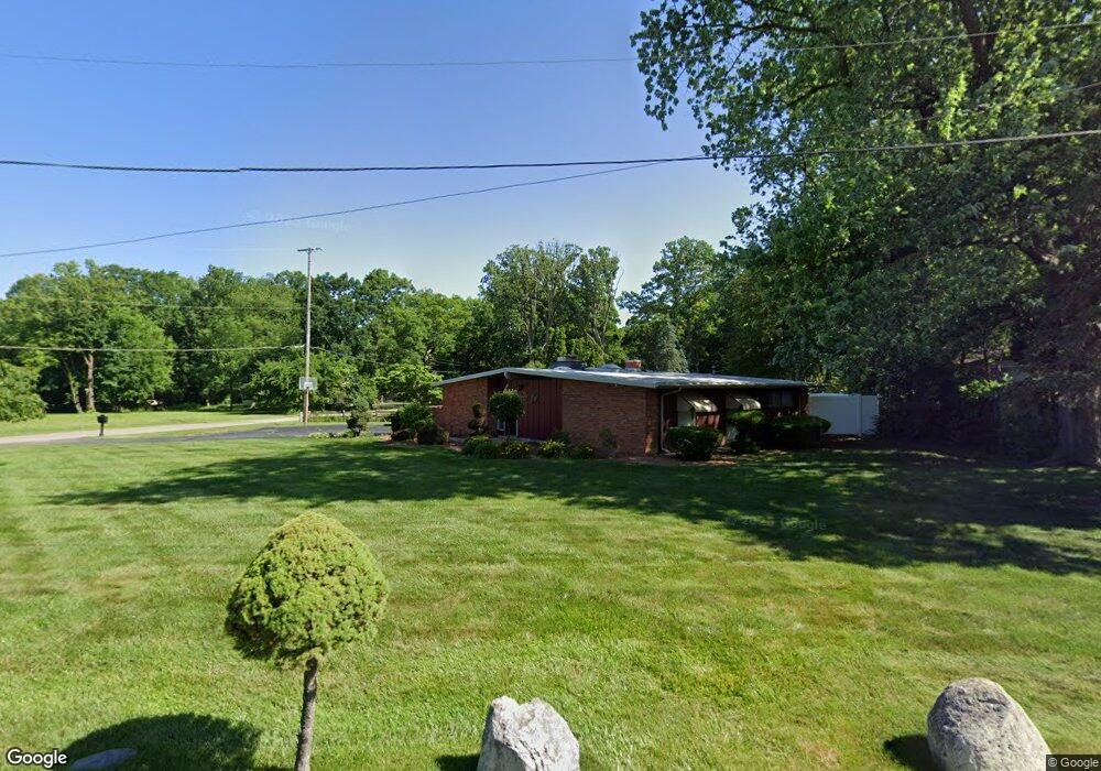
2921 Hillcrest Ave Flint, MI 48507
Circle Neighborhood NeighborhoodEstimated Value: $140,000 - $169,000
3
Beds
2
Baths
1,660
Sq Ft
$93/Sq Ft
Est. Value
About This Home
This home is located at 2921 Hillcrest Ave, Flint, MI 48507 and is currently estimated at $155,185, approximately $93 per square foot. 2921 Hillcrest Ave is a home located in Genesee County with nearby schools including Freeman Elementary School, Flint Southwestern Classical Academy, and International Academy of Flint (K-12).
Ownership History
Date
Name
Owned For
Owner Type
Purchase Details
Closed on
Sep 11, 2025
Sold by
Lathon Rosa L
Bought by
Lathon Rosa L and Lathon Mia N
Current Estimated Value
Purchase Details
Closed on
Mar 26, 2014
Sold by
Grose Helen
Bought by
Lathon Rosa
Purchase Details
Closed on
Dec 12, 2013
Sold by
Deutsche Bank National Trust Company
Bought by
Grose Helen
Purchase Details
Closed on
Apr 3, 2013
Sold by
Lathon Rosa
Bought by
Deutsche Bank National Trust Company
Create a Home Valuation Report for This Property
The Home Valuation Report is an in-depth analysis detailing your home's value as well as a comparison with similar homes in the area
Home Values in the Area
Average Home Value in this Area
Purchase History
| Date | Buyer | Sale Price | Title Company |
|---|---|---|---|
| Lathon Rosa L | -- | None Listed On Document | |
| Lathon Rosa L | -- | None Listed On Document | |
| Lathon Rosa | $40,000 | Fidelity National Title | |
| Grose Helen | $15,000 | Servicelink | |
| Deutsche Bank National Trust Company | $149,116 | None Available |
Source: Public Records
Tax History
| Year | Tax Paid | Tax Assessment Tax Assessment Total Assessment is a certain percentage of the fair market value that is determined by local assessors to be the total taxable value of land and additions on the property. | Land | Improvement |
|---|---|---|---|---|
| 2025 | $2,229 | $78,800 | $0 | $0 |
| 2024 | $1,976 | $74,600 | $0 | $0 |
| 2023 | $1,916 | $64,000 | $0 | $0 |
| 2022 | $0 | $52,400 | $0 | $0 |
| 2021 | $2,021 | $48,600 | $0 | $0 |
| 2020 | $1,779 | $45,900 | $0 | $0 |
| 2019 | $1,706 | $36,600 | $0 | $0 |
| 2018 | $1,800 | $33,700 | $0 | $0 |
| 2017 | $1,740 | $0 | $0 | $0 |
| 2016 | $1,726 | $0 | $0 | $0 |
| 2015 | -- | $0 | $0 | $0 |
| 2014 | -- | $0 | $0 | $0 |
| 2012 | -- | $34,800 | $0 | $0 |
Source: Public Records
Map
Nearby Homes
- 2910 Shawnee Ave
- 3110 Menominee Ave
- 3505 Comanche Ave
- 3009 Menominee Ave
- 720 Algonquin Ave
- 3617 Circle Dr
- 2221 Howard Ave
- 630 Buckingham Ave
- 2224 Crocker Ave
- 621 Burroughs Ave
- 3218 Collingwood Pkwy
- 366 E Atherton Rd
- 2029 Winans Ave
- 213 E Lakeview Ave
- 420 Burroughs Ave
- 352 Buckingham Ave
- 3222 Chambers St
- 4126 Circle Dr
- 149 E Linsey Blvd
- 326 Burroughs Ave
- 2901 Hillcrest Ave
- 2915 Hillcrest Ave
- 715 Country Club Ln
- 3001 Circle Dr
- 2806 Dearborn Ave
- 2841 Hillcrest Ave
- 3002 Circle Dr
- 2946 Circle Dr
- 714 Country Club Ln
- 2810 Dearborn Ave
- 2802 Dearborn Ave
- 2826 Hillcrest Ave
- 3009 Circle Dr
- 2938 Circle Dr
- 3010 Circle Dr
- 2902 Dearborn Ave
- 2821 Hillcrest Ave
- 2818 Hillcrest Ave
- 3019 Circle Dr
- 2930 Circle Dr
Your Personal Tour Guide
Ask me questions while you tour the home.