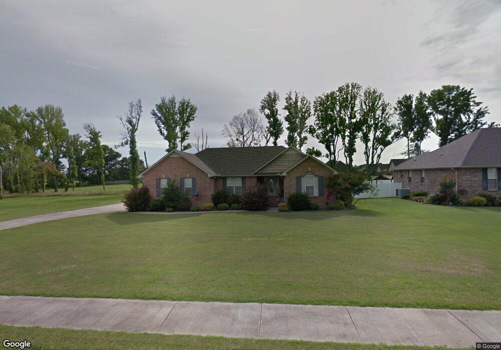
29313 Briar Patch Ln Ardmore, AL 35739
Ardmore NeighborhoodEstimated Value: $266,301 - $326,000
Studio
1
Bath
1,648
Sq Ft
$174/Sq Ft
Est. Value
About This Home
This home is located at 29313 Briar Patch Ln, Ardmore, AL 35739 and is currently estimated at $286,325, approximately $173 per square foot. 29313 Briar Patch Ln is a home with nearby schools including Cedar Hill Elementary School and Ardmore High School.
Ownership History
Date
Name
Owned For
Owner Type
Purchase Details
Closed on
Aug 23, 2006
Sold by
Douthit Neal
Bought by
Steelman Larry C and Steelman Brandy G
Current Estimated Value
Home Financials for this Owner
Home Financials are based on the most recent Mortgage that was taken out on this home.
Original Mortgage
$168,500
Outstanding Balance
$99,087
Interest Rate
6.67%
Estimated Equity
$187,238
Create a Home Valuation Report for This Property
The Home Valuation Report is an in-depth analysis detailing your home's value as well as a comparison with similar homes in the area
Home Values in the Area
Average Home Value in this Area
Purchase History
| Date | Buyer | Sale Price | Title Company |
|---|---|---|---|
| Steelman Larry C | -- | -- |
Source: Public Records
Mortgage History
| Date | Status | Borrower | Loan Amount |
|---|---|---|---|
| Open | Steelman Larry C | $168,500 |
Source: Public Records
Tax History
| Year | Tax Paid | Tax Assessment Tax Assessment Total Assessment is a certain percentage of the fair market value that is determined by local assessors to be the total taxable value of land and additions on the property. | Land | Improvement |
|---|---|---|---|---|
| 2025 | $1,077 | $27,500 | $0 | $0 |
| 2024 | $1,077 | $26,140 | $0 | $0 |
| 2023 | $1,023 | $24,880 | $0 | $0 |
| 2022 | $833 | $21,400 | $0 | $0 |
| 2021 | $730 | $18,820 | $0 | $0 |
| 2020 | $670 | $17,320 | $0 | $0 |
| 2019 | $696 | $17,980 | $0 | $0 |
| 2018 | $629 | $16,300 | $0 | $0 |
| 2017 | $599 | $16,300 | $0 | $0 |
| 2016 | $599 | $162,740 | $0 | $0 |
| 2015 | $629 | $16,300 | $0 | $0 |
| 2014 | $619 | $0 | $0 | $0 |
Source: Public Records
Map
Nearby Homes
- .86 acres Whitt St
- 29645 3rd Ave E
- 29854 Ardmore Ave
- 29401 Alabama 251
- .91 Brock Rd
- .97 Brock Rd
- 25433 7th St
- 25467 7th St
- 10A Shannon Rd
- 8A Shannon Rd
- 29875 1st Ave E
- 3.81 Acres Alabama 53
- 27615 Shannon Rd
- 28669 Alabama Highway 251
- 30407 Highway 110
- 26210 Stateline Rd
- 0 Sterling Rd
- 26454 Austin Whitt Rd
- 28833 Joe Scott Dr
- 28821 Joe Scott Dr
- 29333 Briar Patch Ln
- 0 Briar Patch Rd Unit 1827446
- 0 Briar Patch Rd Unit 1082654
- 0 Briar Patch Rd Unit 420527
- 0 Briar Patch Rd Unit 519815
- 0 Briar Patch Rd Unit 996513
- 29293 Briar Patch Ln
- 29351 Briar Patch Ln
- 29312 Briar Patch Ln
- 29278 Amys Cir
- 29330 Briar Patch Ln
- 29292 Amy Cir
- 29278 Amy Cir
- 29264 Amy Cir
- 29308 Amy Cir
- 29308 Amys Cir
- 29348 Briar Patch Ln
- 29256 Amy Cir
- 29367 Briar Patch Ln
- 29324 Amy Cir
Your Personal Tour Guide
Ask me questions while you tour the home.