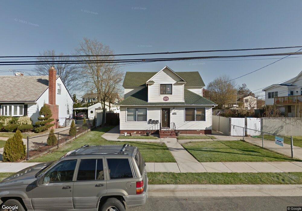
295 Roosevelt Ave Unit 1F Freeport, NY 11520
Estimated Value: $817,961 - $830,000
1
Bed
1
Bath
2,536
Sq Ft
$325/Sq Ft
Est. Value
About This Home
This home is located at 295 Roosevelt Ave Unit 1F, Freeport, NY 11520 and is currently estimated at $823,981, approximately $324 per square foot. 295 Roosevelt Ave Unit 1F is a home located in Nassau County with nearby schools including Columbus Avenue School, Caroline G. Atkinson Intermediate School, and John W Dodd Middle School.
Ownership History
Date
Name
Owned For
Owner Type
Purchase Details
Closed on
Oct 19, 2022
Sold by
Blue Sky Resources Inc
Bought by
Cohen Israel and Cohen Sippora
Current Estimated Value
Purchase Details
Closed on
Jul 22, 2010
Sold by
Raviv Lior
Bought by
Blue Sky Resources Inc
Purchase Details
Closed on
Mar 24, 2003
Sold by
Blue Sky Resources Inc
Purchase Details
Closed on
Jul 2, 2001
Purchase Details
Closed on
May 10, 2001
Sold by
El Capital
Bought by
Ravir Lior
Purchase Details
Closed on
May 13, 1997
Sold by
Ragucci Ralph
Bought by
El Capital Inc
Create a Home Valuation Report for This Property
The Home Valuation Report is an in-depth analysis detailing your home's value as well as a comparison with similar homes in the area
Home Values in the Area
Average Home Value in this Area
Purchase History
| Date | Buyer | Sale Price | Title Company |
|---|---|---|---|
| Cohen Israel | $660,000 | Your Title Experts | |
| Blue Sky Resources Inc | -- | -- | |
| -- | -- | -- | |
| -- | -- | -- | |
| Ravir Lior | $204,000 | Micheal Steiner | |
| El Capital Inc | $150,850 | -- |
Source: Public Records
Tax History
| Year | Tax Paid | Tax Assessment Tax Assessment Total Assessment is a certain percentage of the fair market value that is determined by local assessors to be the total taxable value of land and additions on the property. | Land | Improvement |
|---|---|---|---|---|
| 2025 | $8,237 | $382 | $141 | $241 |
| 2024 | $855 | $398 | $147 | $251 |
Source: Public Records
Map
Nearby Homes
- 267 Roosevelt Ave
- 265 Roosevelt Ave
- 36 Casino St
- 173 Cedar St
- 119 S Bay Ave
- 494 S Ocean Ave Unit 1M
- 494 S Ocean Ave Unit 1H
- 494 S Ocean Ave Unit 3A
- 160 Saint Marks Ave
- 48 Saint Marks Ave
- 13 Noon Place
- 463 S Bayview Ave
- 226 Westside Ave Unit B
- 403 S Bayview Ave
- 433 Miller Ave
- 587 S Bayview Ave
- 572 S Bayview Ave
- 208 Sportsmans Ave
- 470 Miller Ave
- 292 Westside Ave
- 295 Roosevelt Ave
- 293 Roosevelt Ave
- 297 Roosevelt Ave
- 299 Roosevelt Ave
- 482 S Long Beach Ave
- 289 Roosevelt Ave
- 456 S Long Beach Ave
- 456 S Long Beach Ave
- 486 S Long Beach Ave
- 294 Roosevelt Ave
- 462 S Long Beach Ave
- 305 Roosevelt Ave
- 300 Roosevelt Ave
- 292 Roosevelt Ave
- 271 Roosevelt Ave
- 304 Roosevelt Ave
- 6 Casino St
- 446 S Long Beach Ave
- 288 Roosevelt Ave
Your Personal Tour Guide
Ask me questions while you tour the home.