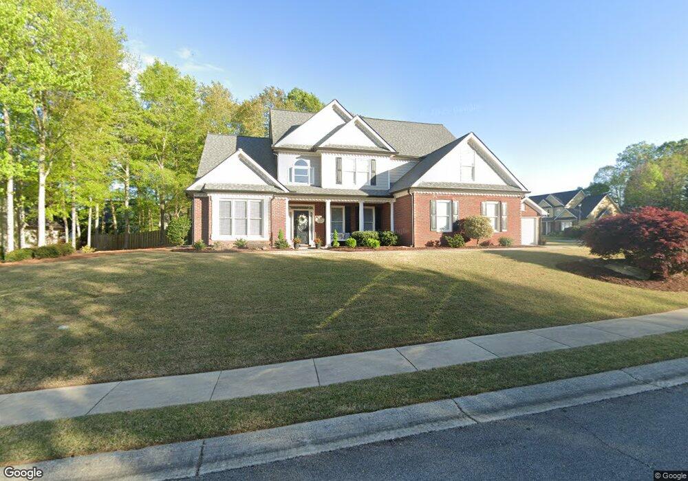
2967 Legislative Ln Unit 1 Buford, GA 30519
Estimated Value: $533,000 - $570,000
4
Beds
4
Baths
2,960
Sq Ft
$187/Sq Ft
Est. Value
About This Home
This home is located at 2967 Legislative Ln Unit 1, Buford, GA 30519 and is currently estimated at $554,612, approximately $187 per square foot. 2967 Legislative Ln Unit 1 is a home located in Hall County with nearby schools including Friendship Elementary School, Cherokee Bluff Middle School, and Cherokee Bluff High School.
Ownership History
Date
Name
Owned For
Owner Type
Purchase Details
Closed on
May 24, 2004
Sold by
Tompkins William V and Tompkins Patricia B
Bought by
Davis Stanley L
Current Estimated Value
Home Financials for this Owner
Home Financials are based on the most recent Mortgage that was taken out on this home.
Original Mortgage
$200,000
Outstanding Balance
$87,414
Interest Rate
4.75%
Mortgage Type
New Conventional
Estimated Equity
$467,198
Purchase Details
Closed on
Aug 22, 2003
Sold by
W J Brooks Inc
Bought by
Tompkins William V and Tompkins Patricia
Home Financials for this Owner
Home Financials are based on the most recent Mortgage that was taken out on this home.
Original Mortgage
$150,000
Interest Rate
5.72%
Mortgage Type
New Conventional
Purchase Details
Closed on
Jul 9, 2002
Sold by
Chateau Corners Development Corp
Bought by
W J Brooks Inc
Create a Home Valuation Report for This Property
The Home Valuation Report is an in-depth analysis detailing your home's value as well as a comparison with similar homes in the area
Home Values in the Area
Average Home Value in this Area
Purchase History
| Date | Buyer | Sale Price | Title Company |
|---|---|---|---|
| Davis Stanley L | $250,000 | -- | |
| Tompkins William V | $249,900 | -- | |
| W J Brooks Inc | $490,000 | -- |
Source: Public Records
Mortgage History
| Date | Status | Borrower | Loan Amount |
|---|---|---|---|
| Open | Davis Stanley L | $200,000 | |
| Previous Owner | Tompkins William V | $150,000 |
Source: Public Records
Tax History
| Year | Tax Paid | Tax Assessment Tax Assessment Total Assessment is a certain percentage of the fair market value that is determined by local assessors to be the total taxable value of land and additions on the property. | Land | Improvement |
|---|---|---|---|---|
| 2025 | $3,902 | $220,680 | $45,480 | $175,200 |
| 2024 | $6,949 | $278,840 | $44,960 | $233,880 |
| 2023 | $3,582 | $161,282 | $30,200 | $131,082 |
| 2022 | $3,781 | $146,520 | $28,560 | $117,960 |
| 2021 | $3,271 | $124,784 | $17,000 | $107,784 |
| 2020 | $3,229 | $119,784 | $17,000 | $102,784 |
| 2019 | $3,046 | $112,104 | $16,000 | $96,104 |
| 2018 | $3,083 | $109,904 | $16,000 | $93,904 |
| 2017 | $2,880 | $100,344 | $12,080 | $88,264 |
| 2016 | $2,467 | $88,300 | $12,116 | $76,184 |
| 2015 | $2,604 | $88,300 | $12,116 | $76,184 |
| 2014 | $2,604 | $92,408 | $12,116 | $80,291 |
Source: Public Records
Map
Nearby Homes
- 2638 Democracy Dr Unit 1
- 2244 Mayors Way
- 2342 Sparta Way
- 3138 Lantana Way
- 7512 Clover
- 7500 Clover
- 7413 Quinn Place Unit 146
- 7405 Quinn Place Unit LOT 148
- 7420 Quinn Place
- 7401 Quinn Place Unit LOT 149
- 7412 Quinn Place Unit LOT 197
- 7421 Quinn Place
- 7436 Quinn Place
- 7425 Quinn Place
- 7413 Quinn Place
- 7432 Quinn Place Unit LOT 202
- 7424 Quinn Place
- 7436 Quinn Place Unit LOT 203
- 7428 Quinn Place Unit LOT 201
- 7425 Quinn Place Unit 143
- 2979 Legislative Ln
- 2955 Legislative Ln Unit 1
- 2983 Legislative Ln Unit 1
- 2958 Legislative Ln Unit 2958
- 2958 Legislative Ln
- 2958 Legislative Ln
- 2825 Legislative Ln
- 2954 Legislative Ln
- 2966 Legislative Ln
- 2927 Legislative Ln
- 2974 Legislative Ln Unit 1
- 2962 Legislative Ln
- 2829 Legislative Ln
- 2811 Legislative Ln
- 2923 Legislative Ln Unit 1
- 2932 Judicial Place Unit 44
- 2932 Judicial Place Unit 1
- 2833 Legislative Ln
- 2820 Legislative Ln Unit 1
- 2939 Judicial Place
Your Personal Tour Guide
Ask me questions while you tour the home.