Estimated Value: $289,599 - $386,000
Studio
--
Bath
1,633
Sq Ft
$194/Sq Ft
Est. Value
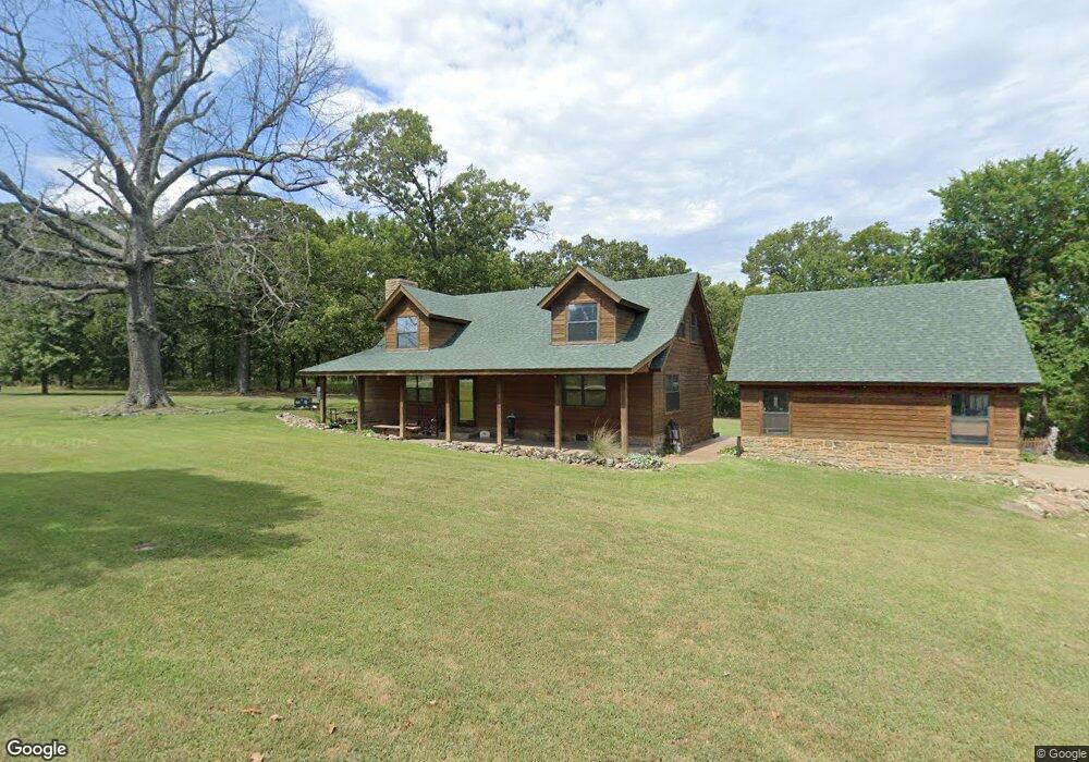
About This Home
This home is located at 29901 S 592 Ln, Grove, OK 74344 and is currently estimated at $317,400, approximately $194 per square foot. 29901 S 592 Ln is a home with nearby schools including Grove Lower Elementary School, Grove Upper Elementary School, and Grove Middle School.
Ownership History
Date
Name
Owned For
Owner Type
Purchase Details
Closed on
Oct 2, 2006
Sold by
Burkholder David and Burkholder Nora
Bought by
Sherrill Jim and Sherrill Kathy
Current Estimated Value
Purchase Details
Closed on
Apr 26, 2000
Sold by
Forrest Family Revocable
Purchase Details
Closed on
Oct 8, 1999
Sold by
Goldner Richard W and Goldner Linda D
Purchase Details
Closed on
Feb 3, 1998
Sold by
Besore Kort A and Besore Karina A
Purchase Details
Closed on
Aug 23, 1997
Sold by
Goldner Richard W and Goldner Linda D
Create a Home Valuation Report for This Property
The Home Valuation Report is an in-depth analysis detailing your home's value as well as a comparison with similar homes in the area
Home Values in the Area
Average Home Value in this Area
Purchase History
| Date | Buyer | Sale Price | Title Company |
|---|---|---|---|
| Sherrill Jim | $168,000 | -- | |
| -- | $25,000 | -- | |
| -- | $25,000 | -- | |
| -- | -- | -- | |
| -- | -- | -- | |
| -- | $63,000 | -- |
Source: Public Records
Mortgage History
| Date | Status | Borrower | Loan Amount |
|---|---|---|---|
| Closed | Sherrill Jim | $0 |
Source: Public Records
Tax History
| Year | Tax Paid | Tax Assessment Tax Assessment Total Assessment is a certain percentage of the fair market value that is determined by local assessors to be the total taxable value of land and additions on the property. | Land | Improvement |
|---|---|---|---|---|
| 2025 | $1,662 | $21,536 | $3,422 | $18,114 |
| 2024 | $1,663 | $21,536 | $3,422 | $18,114 |
| 2023 | $1,663 | $21,536 | $3,014 | $18,522 |
| 2022 | $1,662 | $21,536 | $3,037 | $18,499 |
| 2021 | $1,608 | $20,909 | $3,076 | $17,833 |
| 2020 | $1,519 | $18,928 | $2,473 | $16,455 |
| 2019 | $1,528 | $18,971 | $2,473 | $16,498 |
| 2018 | $1,478 | $18,528 | $2,473 | $16,055 |
| 2017 | $1,437 | $18,418 | $2,473 | $15,945 |
| 2016 | $1,392 | $17,361 | $2,473 | $14,888 |
| 2015 | $1,510 | $18,490 | $2,703 | $15,787 |
| 2014 | $1,517 | $18,490 | $2,703 | $15,787 |
Source: Public Records
Map
Nearby Homes
- 29900 S 592 Place
- 25 S 592 Place
- 27 S 592 Place
- 26 S 592 Place
- 24 S 592 Place
- TBD S 592 Place
- TBD S 592 Lot 25 Place
- TBD S 592 Lot 26
- TBD S 592 Lot 27 Place
- 59421 E 301 Rd
- 59488 E 301 Rd
- 58593 E 296 Place
- 58551 E 296 Place
- 4926 Lost Cove Rd
- 29524 S 585 Ct
- 4971 Lighthouse Springs Dr
- Lot 1 & 2 S 585 Ct
- Lot 1 S 585 Ct
- Lot 2 S 585 Ct
- 29501 S 585 Ct
- 29900 S 592 Ln
- XXXXX Camelia Dr
- 29921 S 592 Place
- 22910 S 592 Ln
- 22900 S 592 Ln
- 29920 S 592 Place
- 29941 S 592 Place
- 29890 S 592 Ln
- 29931 S 592 Ln
- 0 S 592 Ln
- 0 S 592 Place
- 59050 E 300 Rd
- 29951 S 592 Place
- 29940 S 592 Ln
- 29961 S 592 Place
- 29971 S 592 Place
- 29981 S 592 Place
- 59100 E 300 Rd
- 59200 E 300 Rd
- 59070 E 300 Rd
Your Personal Tour Guide
Ask me questions while you tour the home.