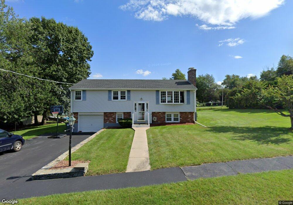
3 Osgood Ave Holden, MA 01520
Estimated Value: $450,712 - $517,000
3
Beds
1
Bath
1,100
Sq Ft
$427/Sq Ft
Est. Value
About This Home
This home is located at 3 Osgood Ave, Holden, MA 01520 and is currently estimated at $469,678, approximately $426 per square foot. 3 Osgood Ave is a home located in Worcester County with nearby schools including Wachusett Regional High School, Abby Kelley Foster Charter Public School, and Bancroft School.
Ownership History
Date
Name
Owned For
Owner Type
Purchase Details
Closed on
Jul 17, 2023
Sold by
Paladino Salvatore F Est and Paladino
Bought by
Paladino Brooke and Paladino Anthony P
Current Estimated Value
Purchase Details
Closed on
Sep 5, 1969
Bought by
Paladino Salvatore F and Paladino Jacqueline R
Create a Home Valuation Report for This Property
The Home Valuation Report is an in-depth analysis detailing your home's value as well as a comparison with similar homes in the area
Home Values in the Area
Average Home Value in this Area
Purchase History
We collect this data history from publicly available records. To have your information removed, we recommend requesting removal directly through your county’s website.
| Date | Buyer | Sale Price | Title Company |
|---|---|---|---|
| Paladino Brooke | -- | None Available | |
| Paladino Salvatore F | -- | -- |
Source: Public Records
Mortgage History
We collect this data history from publicly available records. To have your information removed, we recommend requesting removal directly through your county’s website.
| Date | Status | Borrower | Loan Amount |
|---|---|---|---|
| Previous Owner | Paladino Salvatore F | $75,000 | |
| Previous Owner | Paladino Salvatore F | $75,000 |
Source: Public Records
Tax History
| Year | Tax Paid | Tax Assessment Tax Assessment Total Assessment is a certain percentage of the fair market value that is determined by local assessors to be the total taxable value of land and additions on the property. | Land | Improvement |
|---|---|---|---|---|
| 2025 | $5,867 | $423,300 | $159,300 | $264,000 |
| 2024 | $5,391 | $381,000 | $154,600 | $226,400 |
| 2023 | $5,106 | $340,600 | $134,400 | $206,200 |
| 2022 | $4,975 | $300,400 | $105,000 | $195,400 |
| 2021 | $4,766 | $273,900 | $100,000 | $173,900 |
| 2020 | $4,508 | $265,200 | $95,300 | $169,900 |
| 2019 | $4,369 | $250,400 | $95,300 | $155,100 |
| 2018 | $4,049 | $229,900 | $90,700 | $139,200 |
| 2017 | $3,835 | $218,000 | $90,700 | $127,300 |
| 2016 | $3,595 | $208,400 | $86,400 | $122,000 |
| 2015 | $3,840 | $211,900 | $86,400 | $125,500 |
| 2014 | $3,518 | $198,200 | $86,400 | $111,800 |
Source: Public Records
Map
Nearby Homes
- 239 Woodland St Unit 3
- 38 Juniper Ln
- 25 Pheasant Hill Run
- 30 Mountainshire Dr
- 6 Idalla Ave
- 59 Castine St
- 149 Woodland St
- 24 Park Villa Ave
- 328 Brooks St
- 402 Prospect St
- 7 Darrow St
- 16 Oxford St
- 29R E Mountain St
- 521 Burncoat St
- 156 Hillside Village Dr
- 189 Holden St
- 25 Kings Mountain Dr
- 6 Tucker St
- 15 Tyler Dr
- 14 Angell Brook Dr
- Lot B Sheffield Rd
- Lot D Sheffield Way
- 2 Osgood Ave
- 20 Sheffield Way
- 16 Sheffield Way
- 24 Sheffield Way
- 11 Sheffield Way
- 14 Sheffield Way
- 6 Osgood Ave
- 27 Sheffield Way
- 9 Osgood Ave
- 28 Sheffield Way
- 8 Sheffield Way
- 8 Osgood Ave
- 58 Pinecroft Ave
- 66 Pinecroft Ave
- 47 Osgood Ave
- Lot A Sheffield
- Lot C Sheffield Rd
- 29 Osgood Ave
Your Personal Tour Guide
Ask me questions while you tour the home.