
Seller's Agent in 2025
Karen Powers
Keller Williams Realty Signature Properties
(781) 413-4120
9 in this area
28 Total Sales


Estimated Value: $764,000 - $809,008
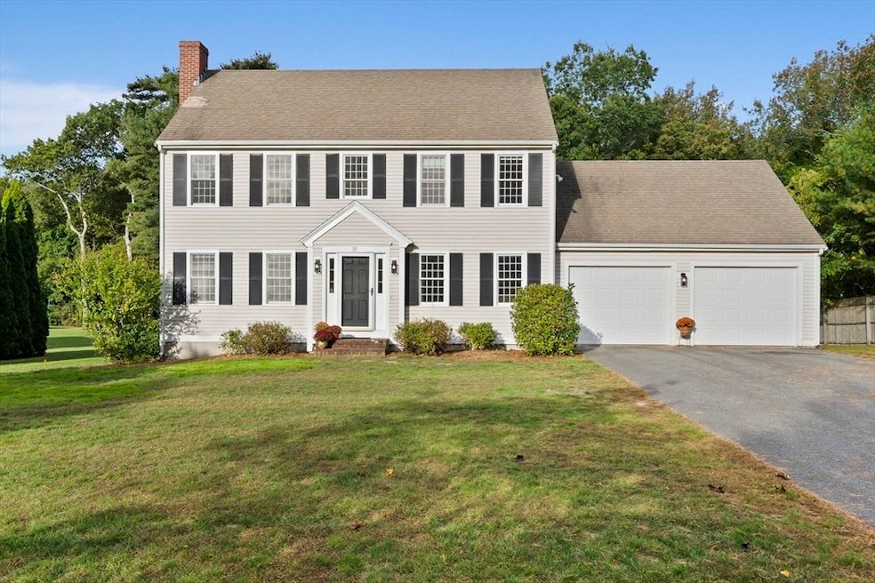
Set in the heart of Marshfield, this 3-bedroom, 2.5-bath Colonial blends warmth, space, and convenience. Step inside to a sun-filled living room with a cozy fireplace—the perfect spot to gather on cool New England evenings. The kitchen and dining area flow easily for everyday living and entertaining, while the walk-out basement offers an opportunity to create additional living space when you’re ready.With over 1,700 sq. ft., an attached two-car garage, and a large yard made for play, gardening, or simply relaxing, this home is designed to grow with you. Upstairs, the bedrooms offer comfort and privacy, and add peace of mind.Enjoy a location that puts you minutes from schools, shopping, and Marshfield’s beaches, giving you the best of town and coastal living. Whether you’re starting your next chapter or looking for more space, 30 Congress Street is ready to welcome you home.
Last Agent to Sell the Property
Keller Williams Realty Signature Properties Listed on: 10/02/2025
We collect this data history from publicly available records. To have your information removed, we recommend requesting removal directly through your county’s website.
| Date | Buyer | Sale Price | Title Company |
|---|---|---|---|
| Burt Kevin | $770,000 | -- | |
| Bandera Robert | $239,200 | -- | |
| Bandera Robert C | $239,200 | -- |
We collect this data history from publicly available records. To have your information removed, we recommend requesting removal directly through your county’s website.
| Date | Status | Borrower | Loan Amount |
|---|---|---|---|
| Open | Burt Kevin | $654,500 | |
| Previous Owner | Bandera Robert C | $150,000 | |
| Previous Owner | Bandera Robert C | $50,000 | |
| Previous Owner | Bandera Robert C | $235,000 | |
| Previous Owner | Bandera Robert C | $227,150 |
| Date | Event | Price | List to Sale | Price per Sq Ft |
|---|---|---|---|---|
| 11/20/2025 11/20/25 | Sold | $770,000 | -3.6% | $451 / Sq Ft |
| 10/13/2025 10/13/25 | Pending | -- | -- | -- |
| 10/02/2025 10/02/25 | For Sale | $799,000 | -- | $468 / Sq Ft |
| Year | Tax Paid | Tax Assessment Tax Assessment Total Assessment is a certain percentage of the fair market value that is determined by local assessors to be the total taxable value of land and additions on the property. | Land | Improvement |
|---|---|---|---|---|
| 2025 | $7,522 | $759,800 | $303,100 | $456,700 |
| 2024 | $7,335 | $706,000 | $288,700 | $417,300 |
| 2023 | $6,849 | $621,200 | $257,800 | $363,400 |
| 2022 | $6,849 | $528,900 | $216,500 | $312,400 |
| 2021 | $6,583 | $499,100 | $216,500 | $282,600 |
| 2020 | $6,281 | $471,200 | $195,900 | $275,300 |
| 2019 | $6,109 | $456,600 | $195,900 | $260,700 |
| 2018 | $6,039 | $451,700 | $195,900 | $255,800 |
| 2017 | $5,956 | $434,100 | $195,900 | $238,200 |
| 2016 | $5,818 | $419,200 | $195,900 | $223,300 |
| 2015 | $5,505 | $414,200 | $195,900 | $218,300 |
| 2014 | $5,430 | $408,600 | $195,900 | $212,700 |
Seller's Agent in 2025
Karen Powers
Keller Williams Realty Signature Properties
(781) 413-4120
9 in this area
28 Total Sales
Buyer's Agent in 2025
Suzanne Nguyen
Access
(857) 312-3377
1 in this area
37 Total Sales
Source: MLS Property Information Network (MLS PIN)
MLS Number: 73438636
APN: MARS-000009E-000001-000043A
Disclaimer: Certain information contained herein is derived from information provided by parties other than Homes.com. All information provided is deemed reliable, but is not guaranteed to be accurate and should be independently verified.
![]() The property listing data and information, or the Images, set forth herein were provided to MLS Property Information Network, Inc. from third party sources, including sellers, lessors and public records, and were compiled by MLS Property Information Network, Inc. The property listing data and information, and the Images, are for the personal, non-commercial use of consumers having a good faith interest in purchasing or leasing listed properties of the type displayed to them and may not be used for any purpose other than to identify prospective properties which such consumers may have a good faith interest in purchasing or leasing. MLS Property Information Network, Inc. and its subscribers disclaim any and all representations and warranties as to the accuracy of the property listing data and information, or as to the accuracy of any of the Images, set forth herein.
The property listing data and information, or the Images, set forth herein were provided to MLS Property Information Network, Inc. from third party sources, including sellers, lessors and public records, and were compiled by MLS Property Information Network, Inc. The property listing data and information, and the Images, are for the personal, non-commercial use of consumers having a good faith interest in purchasing or leasing listed properties of the type displayed to them and may not be used for any purpose other than to identify prospective properties which such consumers may have a good faith interest in purchasing or leasing. MLS Property Information Network, Inc. and its subscribers disclaim any and all representations and warranties as to the accuracy of the property listing data and information, or as to the accuracy of any of the Images, set forth herein.
Ask me questions while you tour the home.