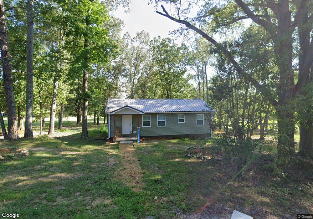
301 Marker Rd Gadsden, AL 35903
Estimated Value: $29,000 - $173,000
3
Beds
1
Bath
1,144
Sq Ft
$111/Sq Ft
Est. Value
About This Home
This home is located at 301 Marker Rd, Gadsden, AL 35903 and is currently estimated at $127,287, approximately $111 per square foot. 301 Marker Rd is a home located in Etowah County with nearby schools including Glencoe Elementary School, Glencoe Middle School, and Glencoe High School.
Ownership History
Date
Name
Owned For
Owner Type
Purchase Details
Closed on
Aug 9, 2019
Sold by
Harris Kendra and Harris Todd
Bought by
Progress Making Forward
Current Estimated Value
Purchase Details
Closed on
Aug 5, 2019
Sold by
Progress Making Forward
Bought by
Johnson Jeff T
Purchase Details
Closed on
Jun 24, 2019
Sold by
Harris Betty N
Bought by
Progress Making Forward
Purchase Details
Closed on
Apr 25, 2019
Sold by
Jennings Sabrina
Bought by
Progress Making Forward
Purchase Details
Closed on
Mar 29, 2019
Sold by
Harris Timothy
Bought by
Progress Making Forward
Create a Home Valuation Report for This Property
The Home Valuation Report is an in-depth analysis detailing your home's value as well as a comparison with similar homes in the area
Home Values in the Area
Average Home Value in this Area
Purchase History
| Date | Buyer | Sale Price | Title Company |
|---|---|---|---|
| Progress Making Forward | -- | -- | |
| Progress Making Forward | -- | -- | |
| Johnson Jeff T | $15,000 | -- | |
| Johnson Jeff T | $15,000 | -- | |
| Progress Making Forward | -- | -- | |
| Progress Making Forward | $500 | -- | |
| Progress Making Forward | -- | -- | |
| Progress Making Forward | -- | -- |
Source: Public Records
Tax History
| Year | Tax Paid | Tax Assessment Tax Assessment Total Assessment is a certain percentage of the fair market value that is determined by local assessors to be the total taxable value of land and additions on the property. | Land | Improvement |
|---|---|---|---|---|
| 2025 | $13 | $260 | $260 | $0 |
| 2024 | $42 | $860 | $860 | $0 |
| 2023 | $52 | $1,060 | $860 | $200 |
| 2022 | $50 | $1,020 | $0 | $0 |
| 2021 | $48 | $0 | $0 | $0 |
| 2020 | $48 | $980 | $0 | $0 |
| 2019 | $48 | $980 | $0 | $0 |
| 2017 | $0 | $660 | $0 | $0 |
| 2016 | $0 | $660 | $0 | $0 |
| 2015 | -- | $660 | $0 | $0 |
| 2013 | -- | $580 | $0 | $0 |
Source: Public Records
Map
Nearby Homes
- 2716 Fields Ave
- 304 Albany Ave
- 0 Albany Ave Unit 21416221
- 130 New York Ave
- 2505 E Broad St
- 4.3 Keeling Rd
- 0 Pennsylvania Ave Unit Unknown 21416333
- 400 Pauline Ave
- 409 Oak St
- 408 Stone St
- 205 Tuskegee Cir
- 425 E Air Depot Rd
- 1107 Dale Dr
- 410 - A Aderholt St
- 0.40 Dale St
- 205 Taylor Rd
- Lot M-3 Copper Leaf Walk E
- 1006 Taylor Rd
- 204 Taylor Rd
- 1200 Taylor Rd
- 3200 Mccord Ave
- 300 Marker Rd
- 2108 Calhoun Dr
- 2116 Mccord Ave
- 2110 Calhoun Dr
- 2112 Calhoun Dr
- 3107 Hillcrest Ave
- 210 Marker Rd
- 0 Cantrell St Unit 1795019
- 2118 Mccord Ave
- 2114 Calhoun Dr
- 0 Mccord Ave
- 2115 Mccord Ave
- 2117 Mccord Ave
- 2111 Calhoun Dr
- 3012 Mccord Ave
- 2118 Calhoun Dr
- 2113 Calhoun Dr
- 201 Hillcrest Ave
- 3015 Dodd St
Your Personal Tour Guide
Ask me questions while you tour the home.