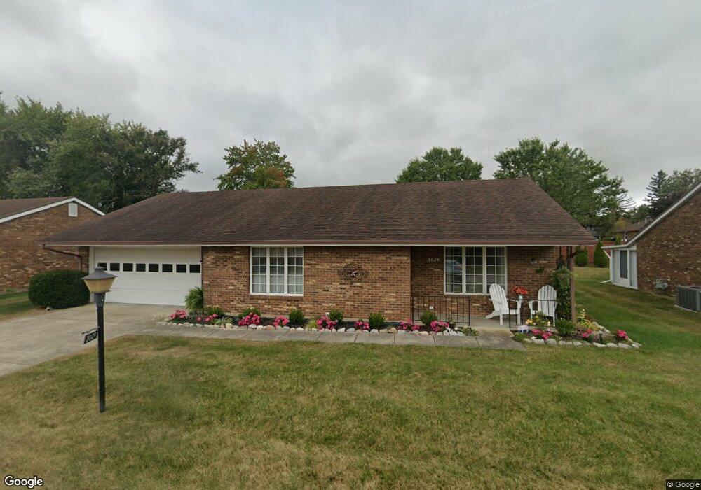
3029 Armsgate Rd Springfield, OH 45503
Estimated Value: $195,000 - $201,000
2
Beds
2
Baths
1,300
Sq Ft
$152/Sq Ft
Est. Value
About This Home
This home is located at 3029 Armsgate Rd, Springfield, OH 45503 and is currently estimated at $197,889, approximately $152 per square foot. 3029 Armsgate Rd is a home located in Clark County with nearby schools including Northridge Elementary School, Kenton Ridge Middle & High School, and Emmanuel Christian Academy.
Ownership History
Date
Name
Owned For
Owner Type
Purchase Details
Closed on
Nov 15, 2019
Sold by
Smith Gloria A
Bought by
Tucker Cynthia M
Current Estimated Value
Home Financials for this Owner
Home Financials are based on the most recent Mortgage that was taken out on this home.
Original Mortgage
$129,600
Interest Rate
3.7%
Mortgage Type
New Conventional
Purchase Details
Closed on
Mar 24, 2015
Sold by
Woyat Anne E
Bought by
Smith Gloria A
Purchase Details
Closed on
May 4, 1989
Bought by
Martin Jerome A and Martin Margaret A
Create a Home Valuation Report for This Property
The Home Valuation Report is an in-depth analysis detailing your home's value as well as a comparison with similar homes in the area
Home Values in the Area
Average Home Value in this Area
Purchase History
| Date | Buyer | Sale Price | Title Company |
|---|---|---|---|
| Tucker Cynthia M | $117,000 | None Available | |
| Smith Gloria A | $90,000 | Team Title & Closing Svcs | |
| Martin Jerome A | $62,500 | -- |
Source: Public Records
Mortgage History
| Date | Status | Borrower | Loan Amount |
|---|---|---|---|
| Closed | Tucker Cynthia M | $129,600 |
Source: Public Records
Tax History
| Year | Tax Paid | Tax Assessment Tax Assessment Total Assessment is a certain percentage of the fair market value that is determined by local assessors to be the total taxable value of land and additions on the property. | Land | Improvement |
|---|---|---|---|---|
| 2025 | $1,329 | $53,050 | $7,350 | $45,700 |
| 2024 | $1,310 | $41,100 | $6,300 | $34,800 |
| 2023 | $1,310 | $41,100 | $6,300 | $34,800 |
| 2022 | $1,693 | $41,100 | $6,300 | $34,800 |
| 2021 | $1,673 | $34,850 | $5,250 | $29,600 |
| 2020 | $1,255 | $34,850 | $5,250 | $29,600 |
| 2019 | $1,280 | $34,850 | $5,250 | $29,600 |
| 2018 | $1,249 | $33,360 | $5,570 | $27,790 |
| 2017 | $1,062 | $30,503 | $5,565 | $24,938 |
| 2016 | $1,055 | $30,503 | $5,565 | $24,938 |
| 2015 | $1,244 | $30,188 | $5,250 | $24,938 |
| 2014 | $1,244 | $30,188 | $5,250 | $24,938 |
| 2013 | $856 | $30,188 | $5,250 | $24,938 |
Source: Public Records
Map
Nearby Homes
- 1013 Abington Place
- 1031 Armsgate Rd Unit 11
- 1039 Bradford Dr Unit 42
- 1139 Bradford Dr
- 1136 Foxboro Rd Unit 202
- 3052 Brixton Dr E
- 3124 El Camino Dr
- 3112 El Camino Dr
- 3135 Imperial Blvd
- 1404 Providence Ave
- 615 Villa Rd Unit B
- 1525 Providence Ave
- 3211 Haverhill St
- 1404 Attleboro Ave
- 732 Grandview Dr Unit 732
- 1201 Kingsgate Rd
- 2943 Tarryton Ln
- 3631 Kingsgate Ln
- 1500 Kingsgate Rd Unit 19430
- 1502 Kingsgate Rd Unit 19432
- 3029 Armsgate Rd
- 3031 Armsgate Rd Unit 17
- 3027 Armsgate Rd
- 3030 Armsgate Rd Unit 26
- 3028 Armsgate Rd
- 3028 Armsgate Rd
- 1025 Armsgate Rd
- 1015 Abington Place Unit 18
- 3120 Derr Rd
- 3034 Armsgate Rd Unit 31
- 3034 Armsgate Rd Unit 24
- 1026 Armsgate Rd
- 1079 Abington Place
- 1027 Armsgate Rd Unit 13
- 1027 Armsgate Rd Unit VILLA
- 1011 Abington Place Unit 20
- 3036 Armsgate Rd
- 3036 Armsgate Rd
- 3033 Bradford Dr
- 1016 Abington Place
Your Personal Tour Guide
Ask me questions while you tour the home.