303 E Mulberry St Lagrange, GA 30241
Estimated payment $89/month
About This Lot
Vacant Lot. Perfect for building/development. Minutes from downtown.
Property Details
Property Type
- Land
Schools
- Ethel W Kight Elementary School
- Gardner Newman Middle School
- Lagrange High School
Additional Features
- 7,841 Sq Ft Lot
- Underground Utilities
Community Details
- No Home Owners Association
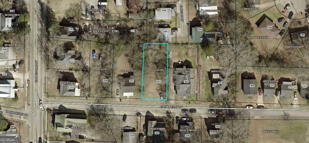
Map
Tax History
| Year | Tax Paid | Tax Assessment Tax Assessment Total Assessment is a certain percentage of the fair market value that is determined by local assessors to be the total taxable value of land and additions on the property. | Land | Improvement |
|---|---|---|---|---|
| 2025 | $93 | $3,400 | $3,400 | $0 |
| 2024 | $93 | $3,400 | $3,400 | $0 |
| 2023 | $93 | $3,400 | $3,400 | $0 |
| 2022 | $95 | $3,400 | $3,400 | $0 |
| 2021 | $62 | $2,040 | $2,040 | $0 |
| 2020 | $62 | $2,040 | $2,040 | $0 |
| 2019 | $48 | $1,600 | $1,600 | $0 |
| 2018 | $48 | $1,600 | $1,600 | $0 |
| 2017 | $215 | $7,120 | $1,600 | $5,520 |
| 2016 | $203 | $6,726 | $1,534 | $5,192 |
| 2015 | $203 | $6,726 | $1,534 | $5,192 |
| 2014 | $204 | $6,726 | $1,534 | $5,192 |
| 2013 | -- | $10,283 | $2,045 | $8,238 |
Property History
| Date | Event | Price | List to Sale | Price per Sq Ft |
|---|---|---|---|---|
| 06/25/2025 06/25/25 | For Sale | $15,000 | -- | -- |
Purchase History
| Date | Type | Sale Price | Title Company |
|---|---|---|---|
| Limited Warranty Deed | $12,484,500 | -- | |
| Limited Warranty Deed | -- | -- | |
| Interfamily Deed Transfer | -- | -- | |
| Deed | -- | -- | |
| Deed | -- | -- | |
| Deed | -- | -- |
Source: Georgia MLS
MLS Number: 10550872
APN: 050-3C-037-015
Disclaimer: Certain information contained herein is derived from information provided by parties other than Homes.com. All information provided is deemed reliable, but is not guaranteed to be accurate and should be independently verified.
![]() The data relating to real estate for sale on this web site comes in part from the Broker Reciprocity Program of Georgia MLS. Real estate listings held by brokerage firms other than Redfin are marked with the Broker Reciprocity logo and detailed information about them includes the name of the listing brokers. Information deemed reliable but not guaranteed. Copyright 2026 Georgia MLS. All rights reserved.
The data relating to real estate for sale on this web site comes in part from the Broker Reciprocity Program of Georgia MLS. Real estate listings held by brokerage firms other than Redfin are marked with the Broker Reciprocity logo and detailed information about them includes the name of the listing brokers. Information deemed reliable but not guaranteed. Copyright 2026 Georgia MLS. All rights reserved.
- 203 Fannin St
- 501 Milam St
- 109 Bell St
- 509 S Lewis St
- 505 S Lewis St
- 200 Mccall St
- 103 Cedar St
- 0 E Fendig St
- 113 E Fendig St
- 112 Cedar St
- 105 Dix St
- 901 Whiteline St
- 0 Boggs St Unit 10550243
- 0 Boggs St Unit 10550231
- 0 Boggs St Unit 10550239
- 0 Boggs St Unit 10550250
- 0 Bagley St
- 0 Locust St
- 0 Burr St
- 306 Burr St
- 206 E Crovat St
- 106 Keyes St
- 910 Truitt Ave Unit B
- 105 Gardenia Ln Unit 105A
- 513 Alford St
- 314 Harwell Ave Unit 1
- 510 Alford St Unit 510B
- 900 Park Ave
- 710 Greenville St
- 815 Forrest Ave
- 1007 Vernon St Unit B
- 707 Jefferson St
- 607 S Lee St Unit B
- 908 Hill St
- 209 N Lee St
- 300 Commerce Ave
- 100 Cross Creek Dr
- 603 Wilburn Ave Unit E
- 110 Elm Dr
- 1700 Park Place

Ask me questions while you tour the home.