Estimated Value: $1,114,129 - $1,195,000
Studio
--
Bath
2,806
Sq Ft
$414/Sq Ft
Est. Value
About This Home
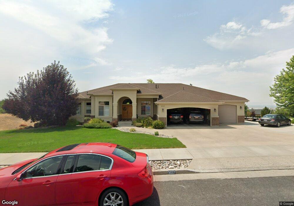
This home is located at 3037 N 1800 E, Logan, UT 84341 and is currently estimated at $1,161,376, approximately $413 per square foot. 3037 N 1800 E is a home with nearby schools including Greenville School, Cedar Ridge School, and North Cache Middle School.
Ownership History
Date
Name
Owned For
Owner Type
Purchase Details
Closed on
Nov 10, 2011
Sold by
Higginbotham Thomas O and Higginbotham Michelle
Bought by
Higginbotham Thomas Olavi and Higginbotham Michelle Lee
Current Estimated Value
Home Financials for this Owner
Home Financials are based on the most recent Mortgage that was taken out on this home.
Original Mortgage
$362,000
Interest Rate
3.87%
Mortgage Type
New Conventional
Purchase Details
Closed on
May 23, 2011
Sold by
Higginbotham Thomas O and Higginbotham Michelle L
Bought by
Higginbotham Thomas Olavi and Higginbotham Michelle Lee
Purchase Details
Closed on
Aug 29, 2005
Sold by
Bruce Carter Construction Inc
Bought by
Higginbotham Thomas O and Higginbotham Michelle L
Home Financials for this Owner
Home Financials are based on the most recent Mortgage that was taken out on this home.
Original Mortgage
$105,350
Interest Rate
5.7%
Mortgage Type
Stand Alone Second
Create a Home Valuation Report for This Property
The Home Valuation Report is an in-depth analysis detailing your home's value as well as a comparison with similar homes in the area
Home Values in the Area
Average Home Value in this Area
Purchase History
We collect this data history from publicly available records. To have your information removed, we recommend requesting removal directly through your county’s website.
| Date | Buyer | Sale Price | Title Company |
|---|---|---|---|
| Higginbotham Thomas Olavi | -- | Northern Title Company | |
| Higginbotham Thomas O | -- | Northern Title Company | |
| Higginbotham Thomas Olavi | -- | None Available | |
| Higginbotham Thomas O | -- | Northern Title Company |
Source: Public Records
Mortgage History
We collect this data history from publicly available records. To have your information removed, we recommend requesting removal directly through your county’s website.
| Date | Status | Borrower | Loan Amount |
|---|---|---|---|
| Closed | Higginbotham Thomas O | $362,000 | |
| Closed | Higginbotham Thomas O | $105,350 | |
| Closed | Higginbotham Thomas O | $359,650 |
Source: Public Records
Tax History
| Year | Tax Paid | Tax Assessment Tax Assessment Total Assessment is a certain percentage of the fair market value that is determined by local assessors to be the total taxable value of land and additions on the property. | Land | Improvement |
|---|---|---|---|---|
| 2025 | $5,041 | $705,695 | $0 | $0 |
| 2024 | $5,386 | $701,575 | $0 | $0 |
| 2023 | $4,869 | $593,455 | $0 | $0 |
| 2022 | $5,095 | $593,455 | $0 | $0 |
| 2021 | $491 | $886,810 | $118,000 | $768,810 |
| 2020 | $4,186 | $708,829 | $118,000 | $590,829 |
| 2019 | $4,384 | $708,828 | $118,000 | $590,828 |
| 2018 | $3,723 | $583,690 | $80,000 | $503,690 |
| 2017 | $3,585 | $295,845 | $0 | $0 |
| 2016 | $3,641 | $295,845 | $0 | $0 |
| 2015 | $2,847 | $230,480 | $0 | $0 |
| 2014 | $2,780 | $230,480 | $0 | $0 |
| 2013 | -- | $230,480 | $0 | $0 |
Source: Public Records
Map
Nearby Homes
- 105 E 3100 N
- 2887 View Crest Cir
- 2350 3025 N
- 1888 E 3375 N
- 1615 N Bronco Rd
- 2275 E Meadow Lark Ln N
- 2758 N Canyon Ridge Dr
- 1340 E 2700 N
- 2738 N Canyon Ridge Dr
- 78 S 1000 E Unit 115
- 16 S 1000 E Unit 101
- 2605 N 2150 E
- 86 S 950 E
- 2611 N 2300 E
- 1139 E Center St
- 2573 N 2300 E Unit 45
- 2540 N 2150 E
- 1112 E 50 N
- 2602 N 2300 E
- 1034 E 50 N
- 3057 N 1800 E
- 3044 N 1800 E
- 1755 N Foothill Dr
- 3062 N 1800 E
- 3008 N 1800 E Unit 19
- 3000 N Canyon Ridge Dr
- 1840 E 3100 N
- 1775 E Canyon Ridge Dr
- 1795 E Canyon Ridge Dr
- 3020 N Canyon Ridge Dr
- 1860 E 3025 N
- 1860 Meadowlark Ln Unit 23
- 1835 E Canyon Ridge Dr
- 1745 E Canyon Ridge Dr
- 3040 N Canyon Ridge Dr
- 1785 E 3100 N
- 1883 E 3025 N
- 1855 E Canyon Ridge Dr
- 1860 E 3100 N Unit 14
- 1860 E 3100 N
Your Personal Tour Guide
Ask me questions while you tour the home.