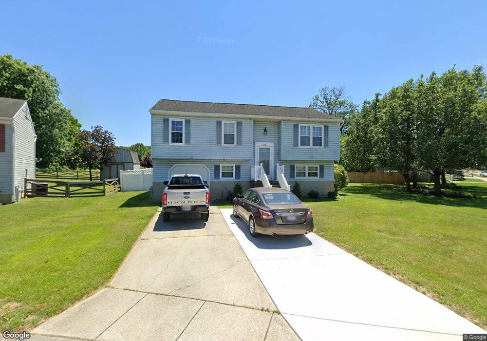
305 Snowbird Cir Brooklyn, MD 21225
Estimated Value: $288,256 - $372,000
Studio
2
Baths
1,108
Sq Ft
$307/Sq Ft
Est. Value
About This Home
This home is located at 305 Snowbird Cir, Brooklyn, MD 21225 and is currently estimated at $340,564, approximately $307 per square foot. 305 Snowbird Cir is a home located in Anne Arundel County with nearby schools including Brooklyn Park Elementary School, Brooklyn Park Middle School, and North County High School.
Ownership History
Date
Name
Owned For
Owner Type
Purchase Details
Closed on
Nov 19, 2025
Sold by
Strauss Gary Wayne and Strauss Donna A
Bought by
Strauss Gary Wayne and Strauss Donna A
Current Estimated Value
Purchase Details
Closed on
May 23, 1989
Sold by
Wooded Valley Assocs
Bought by
Strauss Gary W and Strauss Donna A
Home Financials for this Owner
Home Financials are based on the most recent Mortgage that was taken out on this home.
Original Mortgage
$85,300
Interest Rate
10.69%
Create a Home Valuation Report for This Property
The Home Valuation Report is an in-depth analysis detailing your home's value as well as a comparison with similar homes in the area
Home Values in the Area
Average Home Value in this Area
Purchase History
| Date | Buyer | Sale Price | Title Company |
|---|---|---|---|
| Strauss Gary Wayne | -- | None Listed On Document | |
| Strauss Gary W | $112,400 | -- |
Source: Public Records
Mortgage History
| Date | Status | Borrower | Loan Amount |
|---|---|---|---|
| Previous Owner | Strauss Gary W | $85,300 |
Source: Public Records
Tax History
| Year | Tax Paid | Tax Assessment Tax Assessment Total Assessment is a certain percentage of the fair market value that is determined by local assessors to be the total taxable value of land and additions on the property. | Land | Improvement |
|---|---|---|---|---|
| 2025 | $2,834 | $286,200 | $106,900 | $179,300 |
| 2024 | $2,834 | $278,333 | $0 | $0 |
| 2023 | $2,751 | $270,467 | $0 | $0 |
| 2022 | $2,567 | $262,600 | $106,900 | $155,700 |
| 2020 | $2,441 | $250,467 | $0 | $0 |
| 2019 | $2,401 | $244,400 | $93,900 | $150,500 |
| 2018 | $2,343 | $231,033 | $0 | $0 |
| 2017 | $2,249 | $217,667 | $0 | $0 |
| 2016 | -- | $204,300 | $0 | $0 |
| 2015 | -- | $204,300 | $0 | $0 |
| 2014 | -- | $204,300 | $0 | $0 |
Source: Public Records
Map
Nearby Homes
- 5614 Cliff Side Ct
- 5655 Harbor Valley Dr
- 6028 A Belle Grove Rd
- 275 Rupert Cir
- 944 1st St
- 942 1st St
- 932 1st St
- 5902 Helfrich Rd
- 923 1st St
- 915 1st St
- 635 Sunset Strip
- 907 Victory Ave
- 5300 Brookwood Rd
- 133 Cedar Hill Rd
- 222 Townsend Ave
- 219 Doris Ave
- 308 Holy Cross Rd
- 405 Seward Ave
- 5103 Ballman Ave
- 336 Arden Rd W
- 303 Snowbird Cir
- 5633 Harbor Valley Dr
- 301 Snowbird Cir
- 302 High Rock Ct
- 5636 Harbor Valley Dr
- 5631 Harbor Valley Dr
- 400 Piedmont Ct
- 5639 Harbor Valley Dr
- 5638 Harbor Valley Dr
- 300 High Rock Ct
- 300 Snowbird Cir
- 302 Snowbird Cir
- 304 High Rock Ct
- 402 Piedmont Ct
- 5641 Harbor Valley Dr
- 401 Piedmont Ct
- 301 High Rock Ct
- 306 High Rock Ct
- 5640 Harbor Valley Dr
- 404 Piedmont Ct
Your Personal Tour Guide
Ask me questions while you tour the home.