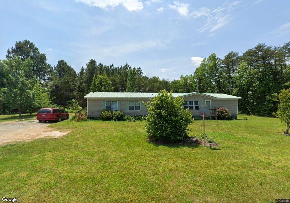
3055 Lennig Rd Nathalie, VA 24577
Estimated Value: $162,291 - $207,000
4
Beds
3
Baths
1,976
Sq Ft
$98/Sq Ft
Est. Value
About This Home
This home is located at 3055 Lennig Rd, Nathalie, VA 24577 and is currently estimated at $192,823, approximately $97 per square foot. 3055 Lennig Rd is a home located in Halifax County with nearby schools including Sydnor Jennings Elementary School, Halifax County Middle School, and Halifax County High School.
Ownership History
Date
Name
Owned For
Owner Type
Purchase Details
Closed on
Aug 31, 2009
Sold by
Burnett Gerald C
Bought by
Lyons Michael
Current Estimated Value
Home Financials for this Owner
Home Financials are based on the most recent Mortgage that was taken out on this home.
Original Mortgage
$103,000
Outstanding Balance
$67,293
Interest Rate
5.17%
Mortgage Type
New Conventional
Estimated Equity
$125,530
Create a Home Valuation Report for This Property
The Home Valuation Report is an in-depth analysis detailing your home's value as well as a comparison with similar homes in the area
Purchase History
| Date | Buyer | Sale Price | Title Company |
|---|---|---|---|
| Lyons Michael | $105,000 | -- |
Source: Public Records
Mortgage History
| Date | Status | Borrower | Loan Amount |
|---|---|---|---|
| Open | Lyons Michael | $103,000 |
Source: Public Records
Tax History
| Year | Tax Paid | Tax Assessment Tax Assessment Total Assessment is a certain percentage of the fair market value that is determined by local assessors to be the total taxable value of land and additions on the property. | Land | Improvement |
|---|---|---|---|---|
| 2025 | $493 | $98,582 | $10,000 | $88,582 |
| 2024 | $493 | $98,582 | $10,000 | $88,582 |
| 2023 | $491 | $98,284 | $10,000 | $88,284 |
| 2022 | $491 | $98,284 | $10,000 | $88,284 |
| 2021 | $406 | $81,211 | $10,000 | $71,211 |
| 2020 | $406 | $81,211 | $10,000 | $71,211 |
| 2019 | $387 | $77,454 | $10,000 | $67,454 |
| 2018 | $372 | $77,454 | $10,000 | $67,454 |
| 2016 | $374 | $77,976 | $10,000 | $67,976 |
| 2015 | $374 | $77,976 | $10,000 | $67,976 |
| 2014 | $359 | $77,976 | $10,000 | $67,976 |
| 2013 | $382 | $84,784 | $10,000 | $74,784 |
Source: Public Records
Map
Nearby Homes
- 1081 Lennig Rd
- 0 Armistead Rd
- 2052 Chisolm Trail
- 0 Chestnut Rd Unit 313027
- 0 Bradley Creek Unit 313020
- L P Bailey Memorial Hwy
- 00 Church Rd
- Tract C Acorn Rd
- 1091 Acorn Rd
- 50.+AC Stoney Ridge Rd
- 1244 Beaver Pond Rd
- 0 Liberty Rd
- 626 H P Anderson Rd
- 0 Rabat Rd Unit 8130-1
- 626 Cardwell Trail
- 2213 Rabat Rd
- 0 Shiloh Church Rd Unit 72994
- 0 T N Snow Rd
- 5 Acres Shiloh Church Rd
- 2028 Clays Mill Rd
- Lenning Lenning Rd
- 1031 Henrys Trail
- 1028 Henrys Trail
- 1022 Henrys Trail
- 1035 Henrys Trail
- 3025 Lennig Rd
- 1011 Woodedge Ln
- 1054 Henrys Trail
- 3100 Lennig Rd
- 1036 Amber Ct
- 1055 Joe Crews Trail
- 1068 Henrys Trail
- 1029 Amberstone Dr
- 1076 Henrys Trail
- 1061 Woodedge Ln
- 1160 Todds Trail
- 1086 Henrys Trail
- 0 Amberstone
- 1140 Henrys Trail
- 29ac Amberstone Dr
Your Personal Tour Guide
Ask me questions while you tour the home.