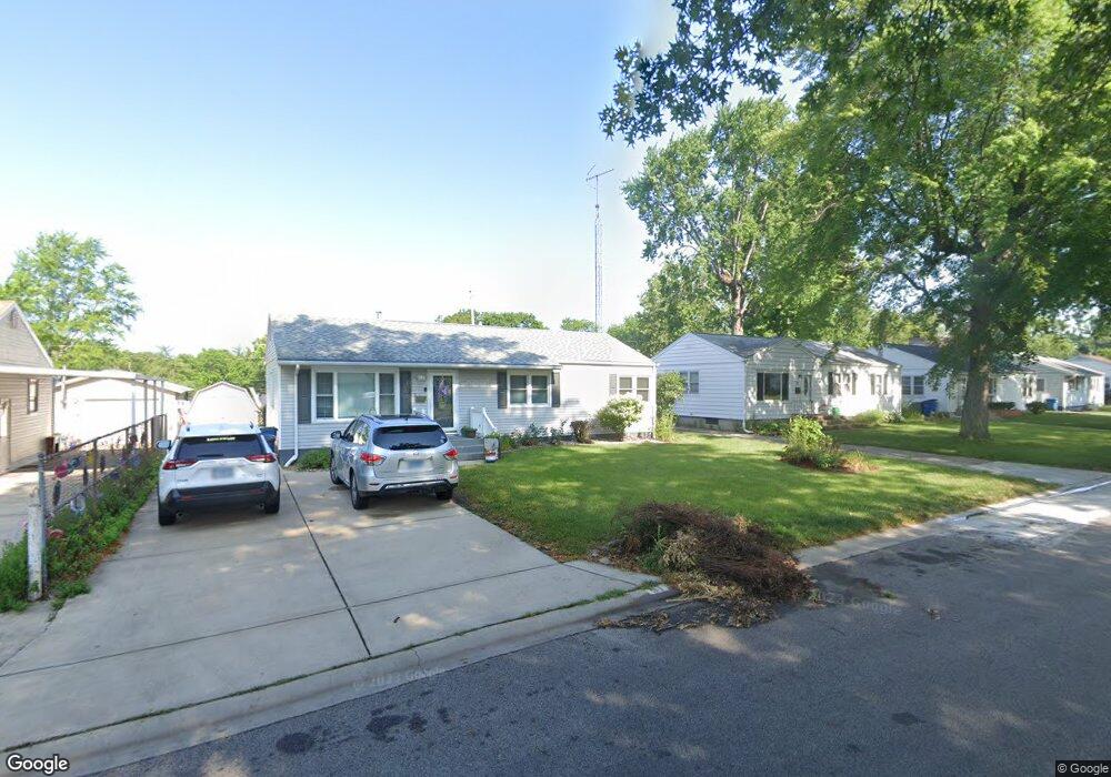
31 Bob o Link Dr Springfield, IL 62702
Estimated Value: $129,000 - $161,000
Studio
--
Bath
--
Sq Ft
6,316
Sq Ft Lot Lot
About This Home
This home is located at 31 Bob o Link Dr, Springfield, IL 62702 and is currently estimated at $142,278. 31 Bob o Link Dr is a home located in Sangamon County with nearby schools including Jane Addams Elementary School, U.S. Grant Middle School, and Springfield High School.
Ownership History
Date
Name
Owned For
Owner Type
Purchase Details
Closed on
Jun 30, 2020
Sold by
Bressan Stephanie A
Bought by
Bressan Stephanie A
Current Estimated Value
Home Financials for this Owner
Home Financials are based on the most recent Mortgage that was taken out on this home.
Original Mortgage
$71,800
Interest Rate
2.67%
Mortgage Type
New Conventional
Purchase Details
Closed on
Dec 26, 2013
Purchase Details
Closed on
Jan 25, 2012
Create a Home Valuation Report for This Property
The Home Valuation Report is an in-depth analysis detailing your home's value as well as a comparison with similar homes in the area
Purchase History
We collect this data history from publicly available records. To have your information removed, we recommend requesting removal directly through your county’s website.
| Date | Buyer | Sale Price | Title Company |
|---|---|---|---|
| Bressan Stephanie A | -- | Amrock Title | |
| -- | -- | -- | |
| -- | -- | -- |
Source: Public Records
Mortgage History
We collect this data history from publicly available records. To have your information removed, we recommend requesting removal directly through your county’s website.
| Date | Status | Borrower | Loan Amount |
|---|---|---|---|
| Previous Owner | Bressan Stephanie A | $71,800 |
Source: Public Records
Tax History
| Year | Tax Paid | Tax Assessment Tax Assessment Total Assessment is a certain percentage of the fair market value that is determined by local assessors to be the total taxable value of land and additions on the property. | Land | Improvement |
|---|---|---|---|---|
| 2024 | $2,881 | $40,298 | $7,715 | $32,583 |
| 2023 | $2,724 | $36,809 | $7,047 | $29,762 |
| 2022 | $2,412 | $34,917 | $6,685 | $28,232 |
| 2021 | $2,485 | $33,610 | $6,435 | $27,175 |
| 2020 | $2,437 | $33,661 | $6,445 | $27,216 |
| 2019 | $2,390 | $33,544 | $6,423 | $27,121 |
| 2018 | $2,454 | $35,043 | $6,392 | $28,651 |
| 2017 | $2,397 | $34,590 | $6,309 | $28,281 |
| 2016 | $2,342 | $34,086 | $6,217 | $27,869 |
| 2015 | $2,314 | $33,679 | $6,143 | $27,536 |
| 2014 | $2,168 | $33,461 | $6,103 | $27,358 |
| 2013 | $2,119 | $32,159 | $6,104 | $26,055 |
Source: Public Records
Map
Nearby Homes
- 24 Sunnyside Dr
- 2011 W Jefferson St
- 2102 W Jefferson St
- 1913 Jeanette Ln Unit 8
- 812 Roanoke Dr
- 890 Roanoke Dr
- 1910 Jeanette Ln Unit 3
- 60 N Oxford Rd
- 2510 & 2518 W Jefferson St
- 2620 Cedar Pond Dr
- 12 N Oxford Rd
- 909 Helene St
- 205 Cranmer Dr
- 232 Dickinson Rd
- 2605 Cardifs Ave
- 340 N Amos Ave
- 143 Springbrook Dr
- 9 Blackberry Run
- 509 Rosehill Ave
- 804 Fairfax Ct
- 35 Bob o Link Dr
- 27 Bob o Link Dr
- 27 Bob-O-link Dr
- 50 Meadowlark Ln
- 23 Bob o Link Dr
- 39 Bob-O-link Dr
- 46 Meadowlark Ln
- 39 Bob o Link Dr
- 42 Meadowlark Ln
- 40 Bob o Link Dr
- 40 Bob-O-link Dr
- 54 Meadowlark Ln
- 44 Bob o Link Dr
- 32 Bob o Link Dr
- 19 Bob o Link Dr
- 43 Bob o Link Dr
- 48 Bob o Link Dr
- 38 Meadowlark Ln
- 58 Meadowlark Ln
- 28 Bob o Link Dr
Your Personal Tour Guide
Ask me questions while you tour the home.