Estimated Value: $746,000 - $794,000
2
Beds
2
Baths
1,572
Sq Ft
$488/Sq Ft
Est. Value
About This Home
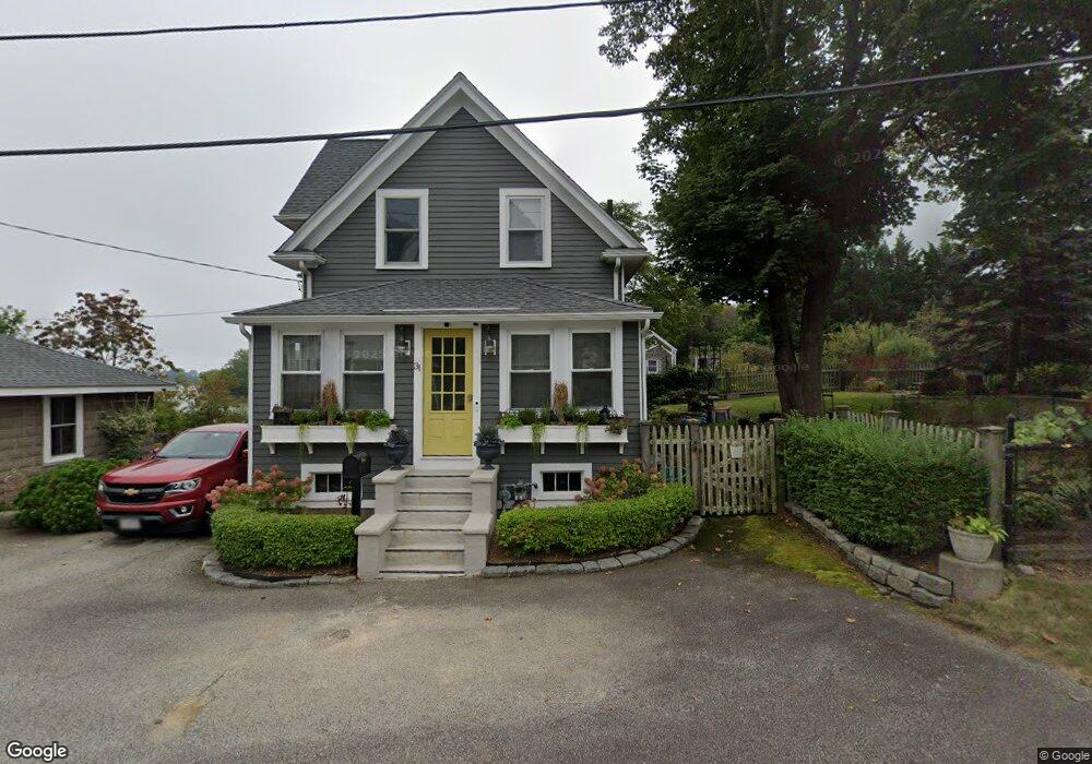
This home is located at 31 Richards Rd, Hull, MA 02045 and is currently estimated at $766,557, approximately $487 per square foot. 31 Richards Rd is a home located in Plymouth County with nearby schools including Lillian M. Jacobs Elementary School, Memorial Middle School, and Hull High School.
Ownership History
Date
Name
Owned For
Owner Type
Purchase Details
Closed on
Oct 7, 2015
Sold by
Ferreira-Reid Linda and Ferreira-Reid Ferrier-Reid
Bought by
Baird James and Baird Deborah A
Current Estimated Value
Home Financials for this Owner
Home Financials are based on the most recent Mortgage that was taken out on this home.
Original Mortgage
$400,000
Outstanding Balance
$309,487
Interest Rate
3.88%
Mortgage Type
New Conventional
Estimated Equity
$457,070
Purchase Details
Closed on
Nov 1, 2012
Sold by
Ferrier-Reid Linda
Bought by
Linda J Ferrier Reid and Linda Ferrier-Reid
Purchase Details
Closed on
Nov 13, 1998
Sold by
Staesa Tr Maxine and Silva Harry L
Bought by
Reid Lawry
Purchase Details
Closed on
Jun 17, 1998
Sold by
Petrocelli and Petrocelli Mark J
Bought by
Ferrier Linda
Purchase Details
Closed on
Nov 14, 1997
Sold by
Mcnamara Robert
Bought by
Petrocelli and Petrocelli Mark J
Create a Home Valuation Report for This Property
The Home Valuation Report is an in-depth analysis detailing your home's value as well as a comparison with similar homes in the area
Purchase History
| Date | Buyer | Sale Price | Title Company |
|---|---|---|---|
| Baird James | $425,000 | -- | |
| Linda J Ferrier Reid | -- | -- | |
| Linda J Ferrier Reid | -- | -- | |
| Reid Lawry | $4,000 | -- | |
| Ferrier Linda | $159,000 | -- | |
| Ferrier Linda J | $159,000 | -- | |
| Petrocelli | $97,500 | -- | |
| Petrocelli | $97,500 | -- |
Source: Public Records
Mortgage History
| Date | Status | Borrower | Loan Amount |
|---|---|---|---|
| Open | Baird James | $400,000 | |
| Previous Owner | Petrocelli | $167,000 | |
| Previous Owner | Petrocelli | $117,000 |
Source: Public Records
Tax History
| Year | Tax Paid | Tax Assessment Tax Assessment Total Assessment is a certain percentage of the fair market value that is determined by local assessors to be the total taxable value of land and additions on the property. | Land | Improvement |
|---|---|---|---|---|
| 2025 | $7,288 | $650,700 | $287,100 | $363,600 |
| 2024 | $7,187 | $616,900 | $268,500 | $348,400 |
| 2023 | $6,893 | $566,400 | $240,800 | $325,600 |
| 2022 | $6,810 | $543,100 | $240,800 | $302,300 |
| 2021 | $6,395 | $504,300 | $213,000 | $291,300 |
| 2020 | $6,133 | $478,400 | $213,000 | $265,400 |
| 2019 | $5,677 | $435,000 | $203,700 | $231,300 |
| 2018 | $7,085 | $414,500 | $203,700 | $210,800 |
| 2017 | $5,500 | $400,900 | $203,700 | $197,200 |
| 2016 | $5,404 | $400,900 | $203,700 | $197,200 |
| 2015 | $5,332 | $382,500 | $185,200 | $197,300 |
| 2014 | $5,305 | $382,500 | $185,200 | $197,300 |
Source: Public Records
Map
Nearby Homes
- 37 Richards Rd Unit A
- 37 Richards Rd
- 0 Seaview Ave
- 18 Valley Beach Ave
- 9 Meade Ave Unit 1
- 6 Montana Ave
- 181 Atlantic Ave
- 6 State Park Rd Unit 2
- 99 Nantasket Ave
- 1 Longbeach Ave Unit 202
- 30 Diab Ln Unit 8
- 62 Oceanside Dr
- 120 Nantasket Ave Unit 207
- 120 Nantasket Ave Unit 204
- 120 Nantasket Ave Unit 304
- 120 Nantasket Ave Unit PH5
- 120 Nantasket Ave Unit 201
- 121 Nantasket Ave Unit 503
- 32 Howe Rd
- 23 Wyola Rd
Your Personal Tour Guide
Ask me questions while you tour the home.