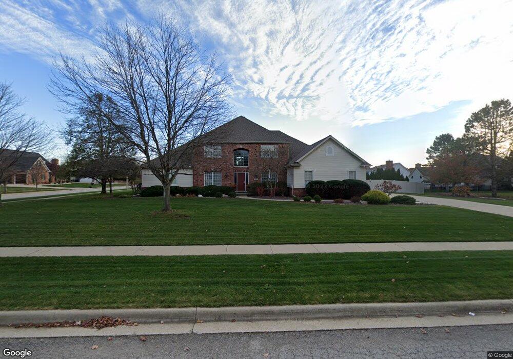
3111 Rusty Ln Bloomington, IL 61704
Hawthorne Hills NeighborhoodEstimated Value: $510,000 - $595,000
4
Beds
3
Baths
3,361
Sq Ft
$167/Sq Ft
Est. Value
About This Home
This home is located at 3111 Rusty Ln, Bloomington, IL 61704 and is currently estimated at $561,366, approximately $167 per square foot. 3111 Rusty Ln is a home located in McLean County with nearby schools including Northpoint Elementary School, Kingsley Junior High School, and Normal Community High School.
Ownership History
Date
Name
Owned For
Owner Type
Purchase Details
Closed on
Jan 4, 2022
Sold by
Fry Thomas D and Fry Anitra K
Bought by
Tohmas D Fry And Anitra K Fry Declaration Of and Fry Anitra
Current Estimated Value
Create a Home Valuation Report for This Property
The Home Valuation Report is an in-depth analysis detailing your home's value as well as a comparison with similar homes in the area
Home Values in the Area
Average Home Value in this Area
Purchase History
We collect this data history from publicly available records. To have your information removed, we recommend requesting removal directly through your county’s website.
| Date | Buyer | Sale Price | Title Company |
|---|---|---|---|
| Tohmas D Fry And Anitra K Fry Declaration Of | -- | Barger Thomas M |
Source: Public Records
Tax History
| Year | Tax Paid | Tax Assessment Tax Assessment Total Assessment is a certain percentage of the fair market value that is determined by local assessors to be the total taxable value of land and additions on the property. | Land | Improvement |
|---|---|---|---|---|
| 2025 | $13,194 | $184,862 | $40,189 | $144,673 |
| 2024 | $10,967 | $174,394 | $37,913 | $136,481 |
| 2022 | $10,967 | $135,116 | $29,374 | $105,742 |
| 2021 | $10,794 | $131,731 | $28,638 | $103,093 |
| 2020 | $10,808 | $131,731 | $28,638 | $103,093 |
| 2019 | $10,457 | $131,731 | $28,638 | $103,093 |
| 2018 | $10,620 | $133,737 | $29,074 | $104,663 |
| 2017 | $10,190 | $133,737 | $29,074 | $104,663 |
| 2016 | $10,387 | $136,466 | $29,667 | $106,799 |
| 2015 | $10,129 | $133,333 | $28,986 | $104,347 |
| 2014 | $11,676 | $153,592 | $28,986 | $124,606 |
| 2013 | -- | $149,119 | $28,142 | $120,977 |
Source: Public Records
Map
Nearby Homes
- 3108 Rusty Ln
- 3203 Eagle Crest Rd
- 2109 Hackberry Rd
- 3301 Wisteria Ln
- 3114 Providence Dr
- 1 Windsong Way
- 3505 Baldocchi Dr
- 7 Smokey Ct
- 2605 Keystone Rd
- 5 Mackenzie Ct
- 1503 Broad Creek Rd
- 3101 Monterey Rd
- 13 Kilborn Ct
- 3210 Monterey Rd
- 22 Long Cove Ct
- 5 Greythorne Cir
- 9 Red Stone Ct
- 379 Larkspur Ln
- 4 Bohrer Ct
- 3601 Baywood Rd
Your Personal Tour Guide
Ask me questions while you tour the home.