3118 S Linwood Ave Independence, MO 64055
Glendale NeighborhoodEstimated Value: $213,000 - $239,000
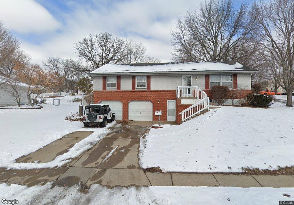
About This Home
Coming soon: Your dream home in the making! Apply now and be among the first to tour when the home becomes available shortly!
Welcome home to an inviting and spacious residence in Independence, MO. This pet-friendly, 3-bedroom, 1-bathroom house offers an array of features that make it a warm and welcoming space. With 1400 square feet of living space, this two-story home stands out with its charming character and ample room for comfort.
Enjoy the airy living room that offers plenty of natural light, perfect for relaxation or entertaining guests. The expansive kitchen boasts modern styling, with ample counter space and cabinets that make meal preparation a joy. Step outside to a generous backyard, ideal for outdoor activities and leisurely afternoons. Additional features include a spacious primary bedroom, designed to be a serene retreat after a long day.
Located just 10 miles from the center of Kansas City, with an estimated driving time of 15 minutes, this home provides easy access to urban amenities while maintaining a peaceful suburban feel. Use your smartphone to control the newly installed smart home technology. This home is managed with love by Elara, a team that's dedicated to making the renting experience effortless and enjoyable for every resident. To apply or schedule a tour, please visit the Elara website. Always apply for Elara homes through listings.elara.one or with the help of a member of our Leasing team. Elara Property Management does not advertise on Craigslist or Facebook Marketplace, and we will never ask you to wire money.
Ownership History
Purchase Details
Purchase Details
Purchase Details
Home Financials for this Owner
Home Financials are based on the most recent Mortgage that was taken out on this home.Home Values in the Area
Average Home Value in this Area
Purchase History
We collect this data history from publicly available records. To have your information removed, we recommend requesting removal directly through your county’s website.
| Date | Buyer | Sale Price | Title Company |
|---|---|---|---|
| Bukaty Michael | -- | None Listed On Document | |
| Bld Realty Llc | $89,251 | None Available | |
| Poffenbaugh Martin C | -- | -- |
Mortgage History
We collect this data history from publicly available records. To have your information removed, we recommend requesting removal directly through your county’s website.
| Date | Status | Borrower | Loan Amount |
|---|---|---|---|
| Previous Owner | Poffenbaugh Martin C | $32,900 |
Property History
| Date | Event | Price | List to Sale | Price per Sq Ft |
|---|---|---|---|---|
| 09/22/2024 09/22/24 | For Rent | $1,565 | -- | -- |
Tax History
| Year | Tax Paid | Tax Assessment Tax Assessment Total Assessment is a certain percentage of the fair market value that is determined by local assessors to be the total taxable value of land and additions on the property. | Land | Improvement |
|---|---|---|---|---|
| 2025 | $2,143 | $29,148 | $5,518 | $23,630 |
| 2024 | $2,143 | $30,936 | $4,283 | $26,653 |
| 2023 | $2,095 | $30,936 | $4,123 | $26,813 |
| 2022 | $1,628 | $22,040 | $4,608 | $17,432 |
| 2021 | $1,627 | $22,040 | $4,608 | $17,432 |
| 2020 | $1,565 | $20,599 | $4,608 | $15,991 |
| 2019 | $1,540 | $20,599 | $4,608 | $15,991 |
| 2018 | $1,500 | $19,150 | $3,734 | $15,416 |
| 2017 | $1,500 | $19,150 | $3,734 | $15,416 |
| 2016 | $1,477 | $18,670 | $3,131 | $15,539 |
| 2014 | $1,403 | $18,126 | $3,040 | $15,086 |
Map
- 16828 E 31st St S
- 16600 E 31st St S
- 16704 E Ellison Way
- 3105 Porter Rd
- 3016 Porter Rd
- 16409 E 31st St S
- 17110 E 31st Terrace S
- 17201 E 32nd St S Unit 9
- 17201 E 32nd St S Unit 3
- 16100 E 34th Terrace S
- 16517 E 35th Street Ct S
- 0 Multi Address N A Unit HMS2588688
- 2900 S M 291 Hwy
- 16701 E George Franklyn Dr
- 16001 E 30th St S
- 2824 Berry Ln
- 15917 E 29th Street Ct S
- 2816 Berry Ln
- 3604 S Bolger Ct
- 3700 S Bolger Ct
- 3200 S Linwood Ave
- 16623 E 32nd St S
- 16724 E 31st Terrace S
- 16619 E 32nd St S
- 16720 E 31st Terrace S
- 3119 S Linwood Ave
- 3201 S Linwood Ave
- 3117 S Linwood Ave
- 16716 E 31st Terrace S
- 3204 S Linwood Ave
- 3205 S Linwood Ave
- 16615 E 32nd St S
- 3113 S Linwood Ave
- 3205 Vest Ave
- 16624 E 32nd St S
- 3209 S Linwood Ave
- 16624 E 32nd Street South N A
- 16712 E 31st Terrace S
- 16620 E 32nd St S
- 3109 S Linwood Ave
Ask me questions while you tour the home.