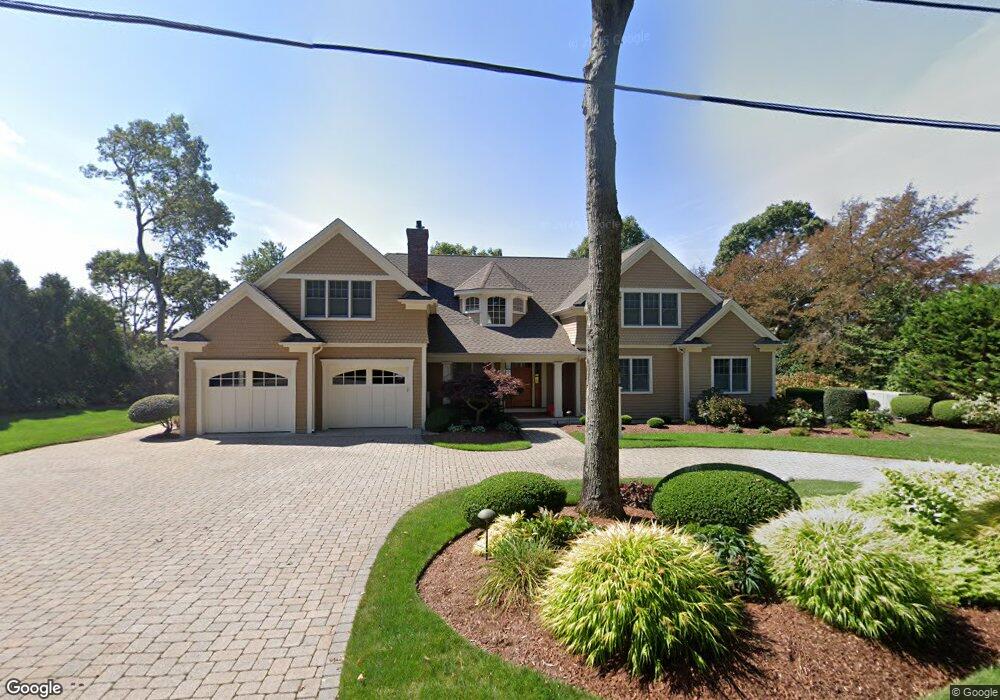
312 Holly Point Rd Centerville, MA 02632
Centerville NeighborhoodEstimated Value: $2,245,000 - $2,602,000
About This Home
This home is located at 312 Holly Point Rd, Centerville, MA 02632 and is currently estimated at $2,446,125, approximately $1,502 per square foot. 312 Holly Point Rd is a home located in Barnstable County with nearby schools including Centerville Elementary School, Barnstable United Elementary School, and Barnstable Intermediate School.
Ownership History
We collect this data history from publicly available records. To have your information removed, we recommend requesting removal directly through your county’s website.
Purchase Details
Home Financials for this Owner
Home Financials are based on the most recent Mortgage that was taken out on this home.Home Values in the Area
Average Home Value in this Area
Purchase History
We collect this data history from publicly available records. To have your information removed, we recommend requesting removal directly through your county’s website.
| Date | Buyer | Sale Price | Title Company |
|---|---|---|---|
| $1,035,000 | -- | ||
| $1,035,000 | -- |
Mortgage History
We collect this data history from publicly available records. To have your information removed, we recommend requesting removal directly through your county’s website.
| Date | Status | Borrower | Loan Amount |
|---|---|---|---|
| Open | $400,000 | ||
| Closed | $500,000 | ||
| Closed | $500,000 |
Tax History
We collect this data history from publicly available records. To have your information removed, we recommend requesting removal directly through your county’s website.
| Year | Tax Paid | Tax Assessment Tax Assessment Total Assessment is a certain percentage of the fair market value that is determined by local assessors to be the total taxable value of land and additions on the property. | Land | Improvement |
|---|---|---|---|---|
| 2025 | $18,160 | $2,244,700 | $991,100 | $1,253,600 |
| 2024 | $17,286 | $2,213,300 | $991,100 | $1,222,200 |
| 2023 | $15,379 | $1,844,000 | $901,000 | $943,000 |
| 2022 | $15,483 | $1,606,100 | $730,000 | $876,100 |
| 2021 | $15,750 | $1,501,400 | $782,200 | $719,200 |
| 2020 | $16,044 | $1,463,900 | $782,200 | $681,700 |
| 2019 | $14,811 | $1,313,000 | $756,100 | $556,900 |
| 2018 | $1,807 | $1,285,300 | $691,600 | $593,700 |
| 2017 | $13,510 | $1,255,600 | $691,600 | $564,000 |
| 2016 | $13,753 | $1,261,700 | $697,700 | $564,000 |
| 2015 | $13,530 | $1,247,000 | $680,400 | $566,600 |
Map
- 61 Angus Way
- 58 Loomis Ln
- 578 Huckins Neck Rd
- 365 Phinneys Ln
- 273 Bishops Terrace
- 159 Willow Run Dr
- 15 Brezner Ln
- 8 Captain Cook Ln Unit 8
- 41 Brezner Ln
- 1431 Iyannough Rd Unit 1
- 66 Tern Ln
- 95 Great Marsh Rd
- 10 Skipjack Ln
- 184 Whitehall Way
- 251 Phinneys Ln
- 6 Scottsdale Rd
- 844 Shootflying Hill Rd
- 42 Eventide Ln
- 228 Phinneys Ln
- 15 Camrose Ct
- 326 Holly Point Rd
- 300 Holly Point Rd
- 319 Holly Point Rd
- 307 Holly Point Rd
- 305 Holly Point Rd
- 336 Holly Point Rd
- 249 Holly Point Rd
- 266 Holly Point Rd
- 345 Holly Point Rd
- 286 Holly Point Rd
- 233 Holly Point Rd
- 256 Holly Point Rd
- 276 Holly Point Rd
- 246 Holly Point Rd
- 346 Holly Point Rd
- 219 Holly Point Rd
- 236 Holly Point Rd
- 346 Lakeside Dr W
- 366 Lakeside Dr W
- 226 Holly Point Rd
Ask me questions while you tour the home.