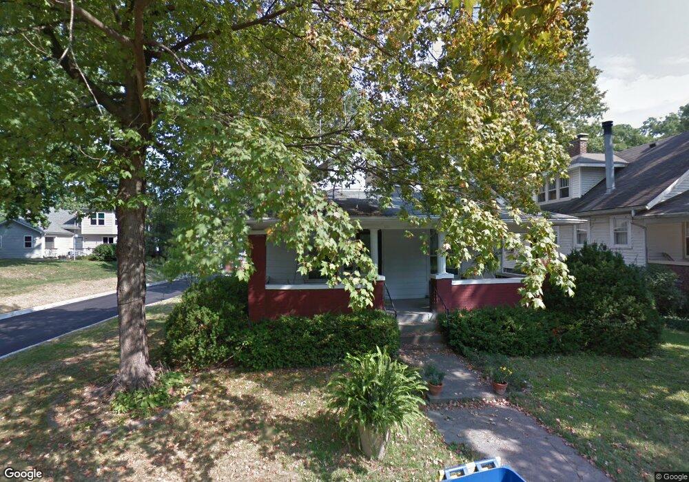
312 Scott St Edwardsville, IL 62025
Estimated Value: $179,061 - $233,000
1
Bed
1
Bath
1,130
Sq Ft
$177/Sq Ft
Est. Value
About This Home
This home is located at 312 Scott St, Edwardsville, IL 62025 and is currently estimated at $199,765, approximately $176 per square foot. 312 Scott St is a home located in Madison County with nearby schools including N.O. Nelson Elementary School, Woodland Elementary School, and Lincoln Middle School.
Ownership History
Date
Name
Owned For
Owner Type
Purchase Details
Closed on
Apr 19, 2010
Sold by
Werner Mark W
Bought by
Schultz Martin W
Current Estimated Value
Purchase Details
Closed on
Apr 14, 2010
Sold by
Werner Bret W
Bought by
Schultz Martin W
Purchase Details
Closed on
Mar 15, 2010
Sold by
Helmich Ruth Anne
Bought by
Schultz Martin W
Purchase Details
Closed on
Mar 13, 2010
Sold by
Schultz Edward B
Bought by
Schultz Martin W
Purchase Details
Closed on
Feb 24, 2010
Sold by
Werner Lisa L
Bought by
Schultz Martin W
Create a Home Valuation Report for This Property
The Home Valuation Report is an in-depth analysis detailing your home's value as well as a comparison with similar homes in the area
Home Values in the Area
Average Home Value in this Area
Purchase History
| Date | Buyer | Sale Price | Title Company |
|---|---|---|---|
| Schultz Martin W | -- | None Available | |
| Schultz Martin W | -- | None Available | |
| Schultz Martin W | -- | None Available | |
| Schultz Martin W | -- | None Available | |
| Schultz Martin W | -- | None Available |
Source: Public Records
Tax History
| Year | Tax Paid | Tax Assessment Tax Assessment Total Assessment is a certain percentage of the fair market value that is determined by local assessors to be the total taxable value of land and additions on the property. | Land | Improvement |
|---|---|---|---|---|
| 2024 | $2,090 | $59,860 | $6,140 | $53,720 |
| 2023 | $2,090 | $55,550 | $5,700 | $49,850 |
| 2022 | $2,120 | $51,350 | $5,270 | $46,080 |
| 2021 | $2,176 | $48,740 | $5,000 | $43,740 |
| 2020 | $2,177 | $47,240 | $4,850 | $42,390 |
| 2019 | $2,201 | $46,450 | $4,770 | $41,680 |
| 2018 | $2,212 | $44,370 | $4,560 | $39,810 |
| 2017 | $2,519 | $43,430 | $4,460 | $38,970 |
| 2016 | $2,044 | $43,430 | $4,460 | $38,970 |
| 2015 | $2,483 | $40,270 | $4,140 | $36,130 |
| 2014 | $2,483 | $40,270 | $4,140 | $36,130 |
| 2013 | $2,483 | $40,270 | $4,140 | $36,130 |
Source: Public Records
Map
Nearby Homes
- 606 N Main St
- 725 Randle St
- 805 Saint Louis St
- 911 Grand Ave
- 217 S Myrtle St
- 229 Commercial St
- 142 West St
- 652 N Kansas St Unit 652-A & B
- 1407 Eberhart Ave
- 316 W Park St
- 505 N Buchanan St
- 317 M St
- 324 M St
- 232 S Main St
- 1012 Briggs St
- APN Briggs St
- 300 S Charles St
- 218 S Fillmore St
- 422 E Park St
- 5 Rock Hill Ct
Your Personal Tour Guide
Ask me questions while you tour the home.