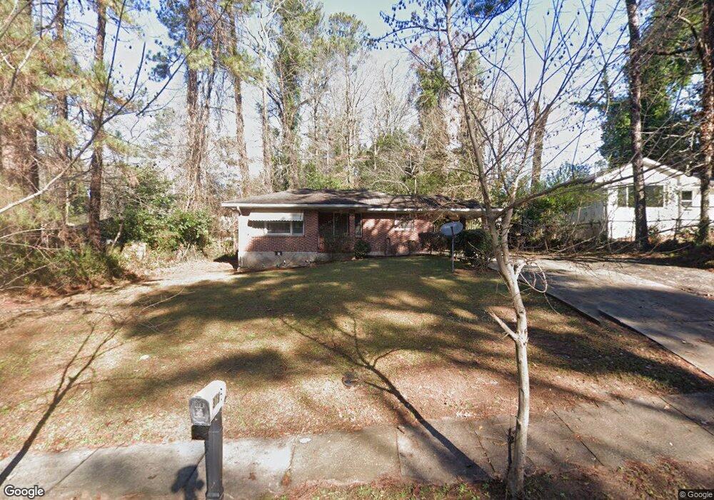
3136 Mcafee Rd Decatur, GA 30032
Estimated Value: $168,818 - $205,000
2
Beds
1
Bath
984
Sq Ft
$191/Sq Ft
Est. Value
About This Home
This home is located at 3136 Mcafee Rd, Decatur, GA 30032 and is currently estimated at $187,455, approximately $190 per square foot. 3136 Mcafee Rd is a home located in DeKalb County with nearby schools including Snapfinger Elementary School, Columbia Middle School, and Columbia High School.
Ownership History
Date
Name
Owned For
Owner Type
Purchase Details
Closed on
Sep 21, 2017
Sold by
Johnson James S
Bought by
Countryside South Inc
Current Estimated Value
Purchase Details
Closed on
Dec 7, 2001
Sold by
Brown Gene S
Bought by
Johnson James S
Home Financials for this Owner
Home Financials are based on the most recent Mortgage that was taken out on this home.
Original Mortgage
$57,000
Interest Rate
6.5%
Create a Home Valuation Report for This Property
The Home Valuation Report is an in-depth analysis detailing your home's value as well as a comparison with similar homes in the area
Home Values in the Area
Average Home Value in this Area
Purchase History
| Date | Buyer | Sale Price | Title Company |
|---|---|---|---|
| Countryside South Inc | -- | -- | |
| Johnson James S | $62,000 | -- |
Source: Public Records
Mortgage History
| Date | Status | Borrower | Loan Amount |
|---|---|---|---|
| Previous Owner | Johnson James S | $57,000 |
Source: Public Records
Tax History
| Year | Tax Paid | Tax Assessment Tax Assessment Total Assessment is a certain percentage of the fair market value that is determined by local assessors to be the total taxable value of land and additions on the property. | Land | Improvement |
|---|---|---|---|---|
| 2025 | $3,370 | $66,560 | $23,296 | $43,264 |
| 2024 | $3,472 | $69,000 | $23,320 | $45,680 |
| 2023 | $3,472 | $60,040 | $23,320 | $36,720 |
Source: Public Records
Map
Nearby Homes
- 3168 Mcafee Rd
- 1968 Rosewood Rd
- 2026 Glendale Dr
- 1997 Glendale Dr
- 1973 Glendale Dr
- 1872 Rosewood Rd
- 1923 Rosewood Rd
- 2082 Rosewood Rd
- 1914 Derrill Dr
- 2004 Shamrock Dr
- 1994 Shamrock Dr
- 1881 Derrill Dr
- 2125 Glendale Dr
- 2131 Glendale Dr
- 1847 Derrill Dr
- 1903 S Columbia Place
- 1979 Creekside Ct
- 1846 Shamrock Dr
- 2175 Glendale Dr
- 1908 S Columbia Place
- 3142 Mcafee Rd
- 3130 Mcafee Rd
- 1996 Rosewood Rd
- 1990 Rosewood Rd
- 2001 Laurel Ln
- 1997 Laurel Ln
- 1991 Laurel Ln
- 1984 Rosewood Rd
- 3133 Mcafee Rd
- 1985 Laurel Ln
- 2003 Rosewood Rd
- 3145 Mcafee Rd
- 1978 Rosewood Rd
- 1995 Rosewood Rd
- 3151 Mcafee Rd
- 1979 Laurel Ln
- 3121 Mcafee Rd
- 2000 Laurel Ln
- 2024 Rosewood Rd
- 2018 Rosewood Rd
Your Personal Tour Guide
Ask me questions while you tour the home.