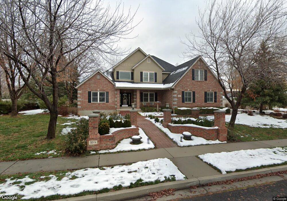
315 River View Dr Alpine, UT 84004
Estimated Value: $1,161,000 - $1,480,000
4
Beds
3
Baths
3,063
Sq Ft
$423/Sq Ft
Est. Value
About This Home
This home is located at 315 River View Dr, Alpine, UT 84004 and is currently estimated at $1,295,443, approximately $422 per square foot. 315 River View Dr is a home located in Utah County with nearby schools including Westfield School, Timberline Middle School, and Lone Peak High School.
Ownership History
Date
Name
Owned For
Owner Type
Purchase Details
Closed on
Jul 1, 2025
Sold by
Macdonald Alan T and Macdonald Linda R
Bought by
Alan T And Linda R Macdonald Family Trust and Macdonald
Current Estimated Value
Purchase Details
Closed on
Dec 13, 2002
Sold by
Jeff Barnes Construction Inc
Bought by
Macdonald Alan T and Macdonald Linda R
Home Financials for this Owner
Home Financials are based on the most recent Mortgage that was taken out on this home.
Original Mortgage
$300,700
Interest Rate
6.06%
Create a Home Valuation Report for This Property
The Home Valuation Report is an in-depth analysis detailing your home's value as well as a comparison with similar homes in the area
Home Values in the Area
Average Home Value in this Area
Purchase History
| Date | Buyer | Sale Price | Title Company |
|---|---|---|---|
| Alan T And Linda R Macdonald Family Trust | -- | None Listed On Document | |
| Macdonald Alan T | -- | Title West Title Co |
Source: Public Records
Mortgage History
| Date | Status | Borrower | Loan Amount |
|---|---|---|---|
| Previous Owner | Macdonald Alan T | $300,700 | |
| Closed | Macdonald Alan T | $48,300 |
Source: Public Records
Tax History
| Year | Tax Paid | Tax Assessment Tax Assessment Total Assessment is a certain percentage of the fair market value that is determined by local assessors to be the total taxable value of land and additions on the property. | Land | Improvement |
|---|---|---|---|---|
| 2025 | $5,187 | $637,835 | -- | -- |
| 2024 | $5,187 | $604,560 | $0 | $0 |
| 2023 | $4,931 | $616,935 | $0 | $0 |
| 2022 | $4,713 | $572,715 | $0 | $0 |
| 2021 | $3,580 | $675,800 | $339,700 | $336,100 |
| 2020 | $3,491 | $644,900 | $308,800 | $336,100 |
| 2019 | $3,018 | $582,100 | $277,100 | $305,000 |
| 2018 | $2,763 | $526,500 | $261,300 | $265,200 |
| 2017 | $2,604 | $264,000 | $0 | $0 |
| 2016 | $2,803 | $264,990 | $0 | $0 |
| 2015 | $2,783 | $248,875 | $0 | $0 |
| 2014 | $2,517 | $222,695 | $0 | $0 |
Source: Public Records
Map
Nearby Homes
- 259 Twin River Loop
- 366 River Rd
- 250 S Main St Unit 25
- 250 S Main St Unit 9
- 250 S Main St Unit 7
- 30 S Main St
- 596 S Cascade Ct
- 48 N 100 E
- 248 Deerfield Dr
- 243 W Conrad Ct
- 868 S Braddock Ln
- 151 Glacier Lily Dr
- 501 W Devey Dr
- 184 S Pfeifferhorn Dr
- 875 S Blue Ridge Ln
- 5843 W Century Heights Dr
- 5852 W Century Heights Dr
- 11952 N 5880 W
- 5046 W Jonathon Rd Unit 10
- 475 Grove Dr
- 273 River View Dr
- 343 S South River View Dr
- 343 River View Dr
- 316 Twin River Loop
- 316 Twin River Loop Unit 39
- 284 Twin River Loop
- 348 Twin River Loop
- 312 River View Dr
- 262 Twin River Loop
- 322 Twin River Loop
- 268 Riverview Dr
- 268 Riverview Dr Unit 46
- 268 River View Dr
- 346 River View Dr
- 366 Twin River Loop
- 255 River View Dr
- 246 Twin River Loop
- 319 River Rd
- 349 Twin River Loop
- 399 W Canyon Crest Rd Unit 1
Your Personal Tour Guide
Ask me questions while you tour the home.