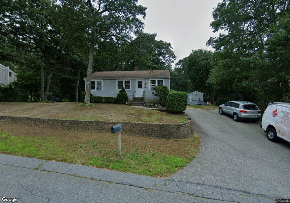
32 Howard Ave Buzzards Bay, MA 02532
Monument Beach NeighborhoodEstimated Value: $427,000 - $465,849
3
Beds
1
Bath
864
Sq Ft
$525/Sq Ft
Est. Value
About This Home
This home is located at 32 Howard Ave, Buzzards Bay, MA 02532 and is currently estimated at $453,212, approximately $524 per square foot. 32 Howard Ave is a home located in Barnstable County with nearby schools including Bourne High School, Cadence Academy Preschool - Bourne, and St Margaret Regional School.
Ownership History
Date
Name
Owned For
Owner Type
Purchase Details
Closed on
Aug 5, 2002
Sold by
Robert Mary J
Bought by
Dicarlo Thomas and Dicarlo Tracey L
Current Estimated Value
Home Financials for this Owner
Home Financials are based on the most recent Mortgage that was taken out on this home.
Original Mortgage
$152,000
Outstanding Balance
$64,732
Interest Rate
6.64%
Mortgage Type
Purchase Money Mortgage
Estimated Equity
$388,480
Create a Home Valuation Report for This Property
The Home Valuation Report is an in-depth analysis detailing your home's value as well as a comparison with similar homes in the area
Home Values in the Area
Average Home Value in this Area
Purchase History
| Date | Buyer | Sale Price | Title Company |
|---|---|---|---|
| Dicarlo Thomas | $160,000 | -- | |
| Dicarlo Thomas | $160,000 | -- |
Source: Public Records
Mortgage History
| Date | Status | Borrower | Loan Amount |
|---|---|---|---|
| Open | Dicarlo Thomas | $152,000 | |
| Closed | Dicarlo Thomas | $152,000 | |
| Previous Owner | Dicarlo Thomas | $15,100 | |
| Previous Owner | Dicarlo Thomas | $30,600 |
Source: Public Records
Tax History
| Year | Tax Paid | Tax Assessment Tax Assessment Total Assessment is a certain percentage of the fair market value that is determined by local assessors to be the total taxable value of land and additions on the property. | Land | Improvement |
|---|---|---|---|---|
| 2025 | $3,003 | $384,500 | $193,800 | $190,700 |
| 2024 | $2,937 | $366,200 | $184,600 | $181,600 |
| 2023 | $2,856 | $324,200 | $163,400 | $160,800 |
| 2022 | $2,749 | $272,400 | $144,600 | $127,800 |
| 2021 | $2,672 | $248,100 | $131,600 | $116,500 |
| 2020 | $2,600 | $242,100 | $130,300 | $111,800 |
| 2019 | $2,480 | $236,000 | $130,300 | $105,700 |
| 2018 | $2,253 | $213,800 | $118,200 | $95,600 |
| 2017 | $2,181 | $211,700 | $117,100 | $94,600 |
| 2016 | $2,106 | $207,300 | $117,100 | $90,200 |
| 2015 | $2,088 | $207,300 | $117,100 | $90,200 |
Source: Public Records
Map
Nearby Homes
- 10 Howard Ave
- 10 Howard Ave
- 77 Roundhouse Rd Unit 77
- 17 Colony Ave
- 566 Shore Rd
- 5 Harbor Hill Dr
- 4 Harbor Hill Dr
- 16 Amberwood Ct
- 12 Turnberry Rd Unit 12
- 2 Applewood Ct
- 4 Hollyhock Knoll Ct Unit 4
- 4 Hollyhock Knoll Ct Unit 4
- 13 Laurel Hill Ct
- 3 1st St
- 709 County Rd
- 14 Navajo Rd
- 3 4th Ave
- 7 4th Ave
- 254 Barlows Landing Rd
- 405 Village Dr Unit 405
Your Personal Tour Guide
Ask me questions while you tour the home.