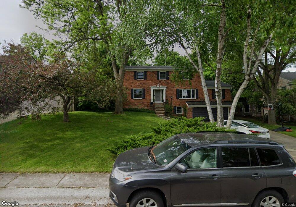
320 Charles Rd Rochester, MI 48307
Estimated Value: $682,621 - $909,000
5
Beds
4
Baths
2,689
Sq Ft
$291/Sq Ft
Est. Value
About This Home
This home is located at 320 Charles Rd, Rochester, MI 48307 and is currently estimated at $782,155, approximately $290 per square foot. 320 Charles Rd is a home located in Oakland County with nearby schools including North Hill Elementary School, Hart Middle School, and Stoney Creek High School.
Ownership History
Date
Name
Owned For
Owner Type
Purchase Details
Closed on
Jan 11, 2018
Sold by
Beaupre David J and Beaupre Mary Ann
Bought by
Beaupre David J and Beaupre Mary Ann
Current Estimated Value
Purchase Details
Closed on
Feb 18, 2015
Sold by
Kleve David A and Kleve Catherine A
Bought by
Kleves Property Management Llc
Purchase Details
Closed on
Jul 10, 2001
Sold by
Hampton John J
Bought by
Kemper Mary A
Home Financials for this Owner
Home Financials are based on the most recent Mortgage that was taken out on this home.
Original Mortgage
$250,000
Interest Rate
7.16%
Create a Home Valuation Report for This Property
The Home Valuation Report is an in-depth analysis detailing your home's value as well as a comparison with similar homes in the area
Home Values in the Area
Average Home Value in this Area
Purchase History
| Date | Buyer | Sale Price | Title Company |
|---|---|---|---|
| Beaupre David J | -- | None Available | |
| Kleves Property Management Llc | -- | None Available | |
| Kemper Mary A | $322,000 | -- |
Source: Public Records
Mortgage History
| Date | Status | Borrower | Loan Amount |
|---|---|---|---|
| Previous Owner | Kemper Mary A | $250,000 |
Source: Public Records
Tax History
| Year | Tax Paid | Tax Assessment Tax Assessment Total Assessment is a certain percentage of the fair market value that is determined by local assessors to be the total taxable value of land and additions on the property. | Land | Improvement |
|---|---|---|---|---|
| 2025 | $6,891 | $326,390 | $0 | $0 |
| 2024 | $6,132 | $300,600 | $0 | $0 |
| 2023 | $5,872 | $276,950 | $0 | $0 |
| 2022 | $6,246 | $262,240 | $0 | $0 |
| 2021 | $5,868 | $264,440 | $0 | $0 |
| 2020 | $5,510 | $259,470 | $0 | $0 |
| 2019 | $6,058 | $260,640 | $0 | $0 |
| 2018 | $6,049 | $247,290 | $0 | $0 |
| 2017 | $5,864 | $224,460 | $0 | $0 |
| 2016 | $5,678 | $217,110 | $0 | $0 |
| 2015 | -- | $198,300 | $0 | $0 |
| 2014 | -- | $181,980 | $0 | $0 |
| 2011 | -- | $153,570 | $0 | $0 |
Source: Public Records
Map
Nearby Homes
- 334 Romeo Rd
- 417 Parkdale Ave Unit 13
- 417 Parkdale Ave Unit 20
- 804 N Main St Unit 2A
- 804 N Main St Unit 2C
- 761 Lounsbury Ave
- 303 Terry Ave
- 164 Albertson St
- 451 Miller Ave Unit 211
- 500 Romeo Rd Unit 122
- 516 Miller Ave
- 836 Miller Ave
- 440 Baldwin Ave Unit 63
- 141 Ferndale Ave
- 342 Maywood Ave
- 1223 N Main St
- 1219 N Main St
- 1158 Churchill Cir
- 420 Baldwin Ave Unit 84
- 420 Baldwin Ave Unit 79
- 326 Charles Rd Unit Bldg-Unit
- 326 Charles Rd
- 316 Charles Rd
- 332 Charles Rd
- 210 Charles Rd
- 321 Charles Rd
- 301 Charles Rd Unit Bldg-Unit
- 301 Charles Rd
- 325 Charles Rd
- 336 Charles Rd
- 208 Charles Rd
- 213 Charles Rd
- 676 N Main St
- 676 N Main St
- 355 Charles Rd
- 320 William Rd
- 209 Charles Rd
- 206 Charles Rd
- 344 Charles Rd
- 316 William Rd
Your Personal Tour Guide
Ask me questions while you tour the home.