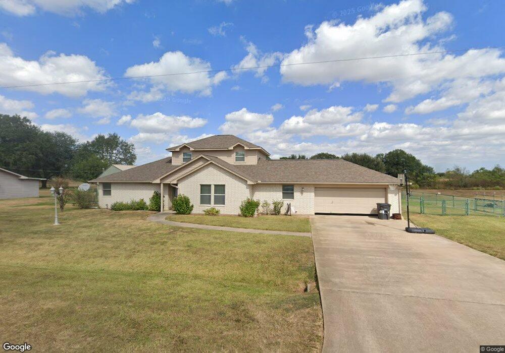
32134 White Wing Dr Waller, TX 77484
Estimated Value: $406,361 - $457,000
Studio
--
Bath
2,272
Sq Ft
$190/Sq Ft
Est. Value
About This Home
This home is located at 32134 White Wing Dr, Waller, TX 77484 and is currently estimated at $431,840, approximately $190 per square foot. 32134 White Wing Dr is a home located in Waller County with nearby schools including H.T. Jones Elementary School, Waller Junior High School, and Waller High School.
Ownership History
Date
Name
Owned For
Owner Type
Purchase Details
Closed on
May 3, 2019
Sold by
Thompson Wayne L and Benson Thompson Delores Nan
Bought by
Griffin Rex and Griffin Barbara
Current Estimated Value
Purchase Details
Closed on
Nov 19, 2007
Sold by
Griffin Rex R
Bought by
Griffin Barbara
Home Financials for this Owner
Home Financials are based on the most recent Mortgage that was taken out on this home.
Original Mortgage
$205,000
Interest Rate
6.43%
Mortgage Type
New Conventional
Create a Home Valuation Report for This Property
The Home Valuation Report is an in-depth analysis detailing your home's value as well as a comparison with similar homes in the area
Purchase History
We collect this data history from publicly available records. To have your information removed, we recommend requesting removal directly through your county’s website.
| Date | Buyer | Sale Price | Title Company |
|---|---|---|---|
| Griffin Rex | -- | Stewart Title Houston Div | |
| Griffin Barbara | -- | None Available |
Source: Public Records
Mortgage History
We collect this data history from publicly available records. To have your information removed, we recommend requesting removal directly through your county’s website.
| Date | Status | Borrower | Loan Amount |
|---|---|---|---|
| Previous Owner | Griffin Barbara | $205,000 |
Source: Public Records
Tax History
| Year | Tax Paid | Tax Assessment Tax Assessment Total Assessment is a certain percentage of the fair market value that is determined by local assessors to be the total taxable value of land and additions on the property. | Land | Improvement |
|---|---|---|---|---|
| 2025 | $5,201 | $416,150 | $112,320 | $303,830 |
| 2024 | $3,561 | $421,720 | $112,320 | $309,400 |
| 2023 | $3,561 | $394,604 | $0 | $0 |
| 2022 | $4,126 | $358,731 | -- | -- |
| 2021 | $6,793 | $342,240 | $56,550 | $285,690 |
| 2020 | $6,321 | $329,300 | $47,500 | $281,800 |
| 2019 | $6,557 | $294,520 | $50,000 | $244,520 |
| 2018 | $5,286 | $245,070 | $25,000 | $220,070 |
| 2017 | $5,315 | $244,550 | $28,000 | $216,550 |
| 2016 | $5,364 | $246,890 | $28,000 | $218,890 |
| 2015 | $4,053 | $224,370 | $22,000 | $202,370 |
| 2014 | $4,053 | $204,410 | $17,500 | $186,910 |
Source: Public Records
Map
Nearby Homes
- 15438 Kitty Hawk Dr
- 15388 Sandtrap Dr
- 32134 Robin Ln
- 15610 Penick Rd
- 32226 Divot Dr
- 32231 Sandwedge Dr
- 32102 Sandwedge Dr
- 32007 Meadow View Ln
- 31229 Rochen Rd
- 1024 Colibri Lake Ln
- 32027 Meadow View Ln
- 14136 Penick Rd
- 14134 Penick Rd
- 33369 Black Falcon Ct
- 14126 Penick Rd
- 0 Mound Creek Rd Unit 91708635
- 16450 Mathis Rd
- 33753 Betka Rd
- 17209 Fm 362 Rd
- 34153 Rochen Rd
- 32210 White Wing Dr
- 32214 White Wing Dr
- 0 Whitewing Dr
- 0000 Whitewing Dr
- LOT 14 White Wing Dr
- 32203 White Wing Dr
- 32215 White Wing Dr
- 32218 White Wing Dr
- 32219 White Wing Dr
- 32210 Sky Lakes Dr
- 32227 White Wing Dr
- 32222 Sky Lakes Dr
- 32226 White Wing Dr
- 32235 White Wing Dr
- 32234 Sky Lakes Dr
- 15410 Kitty Hawk Dr
- 32110 White Wing Dr
- 15422 Kitty Hawk Dr
- 32229 Sky Lakes Dr
- 32242 Sky Lakes Dr
Your Personal Tour Guide
Ask me questions while you tour the home.