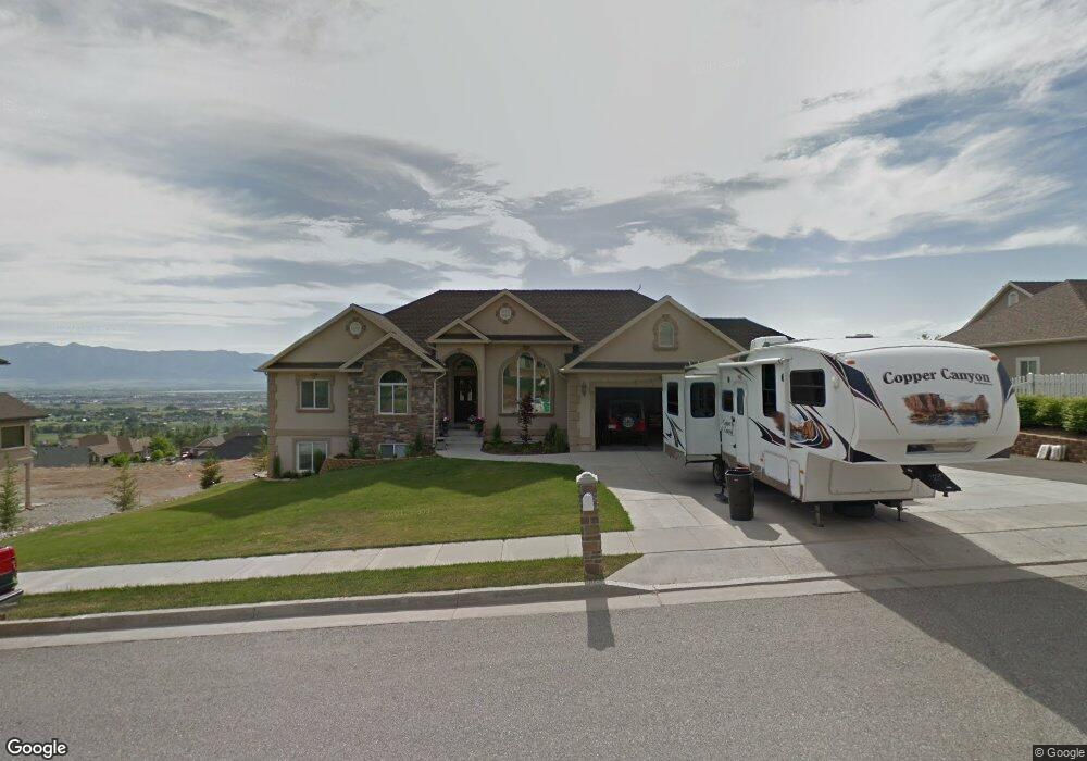
3265 N 1875 E North Logan, UT 84341
Estimated Value: $826,000 - $985,000
8
Beds
5
Baths
4,928
Sq Ft
$186/Sq Ft
Est. Value
About This Home
This home is located at 3265 N 1875 E, North Logan, UT 84341 and is currently estimated at $917,202, approximately $186 per square foot. 3265 N 1875 E is a home located in Cache County with nearby schools including Greenville School, Cedar Ridge School, and North Cache Middle School.
Ownership History
Date
Name
Owned For
Owner Type
Purchase Details
Closed on
Jul 5, 2019
Sold by
Ford Michael R and Ford Tonya
Bought by
Mckenzie Timothy M and Mckenzie Susan
Current Estimated Value
Home Financials for this Owner
Home Financials are based on the most recent Mortgage that was taken out on this home.
Original Mortgage
$575,000
Outstanding Balance
$508,558
Interest Rate
4.5%
Mortgage Type
Adjustable Rate Mortgage/ARM
Estimated Equity
$408,644
Purchase Details
Closed on
May 30, 2018
Sold by
Ford Michael R and Ford Tonya
Bought by
Ford Michael R and Ford Tonya
Purchase Details
Closed on
Aug 5, 2016
Sold by
Finkbeiner Jerry Curtis
Bought by
Ford Michael R and Ford Tonya
Purchase Details
Closed on
Jul 22, 2016
Sold by
Finkbeiner Jerry Curtis and Finkbeiner Reva Ann
Bought by
Finkbeiner Jerry Curtis
Purchase Details
Closed on
Dec 21, 2015
Sold by
Finkbeiner Jerry Curtis and Finkbeiner Reva Ann
Bought by
The Jerry & Reva Finkbeiner Family Trust and Finkbeiner Reva Ann
Purchase Details
Closed on
Jul 2, 2012
Sold by
Lr & Rs Llc
Bought by
Finkbeiner Jerry and Finkbeiner Reva
Home Financials for this Owner
Home Financials are based on the most recent Mortgage that was taken out on this home.
Original Mortgage
$375,250
Interest Rate
3.7%
Mortgage Type
New Conventional
Purchase Details
Closed on
Nov 16, 2011
Sold by
A R & Rs Llc
Bought by
L R & Rs Llc
Purchase Details
Closed on
Aug 20, 2010
Sold by
Stewart Reid S and Stewart Ruth O
Bought by
Ar&Rs Llc
Purchase Details
Closed on
Jan 30, 2008
Sold by
Superior L&L Llc
Bought by
Stewart Reid S and Stewart Ruth O
Purchase Details
Closed on
Jul 23, 2007
Sold by
Professional Builders Inc
Bought by
Superior L&L Llc
Purchase Details
Closed on
May 9, 2006
Sold by
Nyman Family Llc
Bought by
Professional Builders Inc
Purchase Details
Closed on
Nov 26, 2001
Sold by
Sparrow Rick J and Sparrow Tamara L
Bought by
Nyman Family Llc
Purchase Details
Closed on
Sep 27, 2001
Sold by
Nyman Family Llc
Bought by
Sparrow Rick J and Sparrow Tamara L
Create a Home Valuation Report for This Property
The Home Valuation Report is an in-depth analysis detailing your home's value as well as a comparison with similar homes in the area
Home Values in the Area
Average Home Value in this Area
Purchase History
| Date | Buyer | Sale Price | Title Company |
|---|---|---|---|
| Mckenzie Timothy M | -- | Northern Title Company | |
| Ford Michael R | -- | None Available | |
| Ford Michael R | -- | Advanced Title | |
| Finkbeiner Jerry Curtis | -- | Advanced Title | |
| The Jerry & Reva Finkbeiner Family Trust | -- | None Available | |
| Finkbeiner Jerry | -- | Northern Title Company | |
| L R & Rs Llc | -- | None Available | |
| Ar&Rs Llc | -- | Northern Title Company | |
| Stewart Reid S | -- | None Available | |
| Superior L&L Llc | -- | Northern Title Company | |
| Professional Builders Inc | -- | Northern Title Company | |
| Nyman Family Llc | -- | Northern Title Company | |
| Sparrow Rick J | -- | Northern Title Company |
Source: Public Records
Mortgage History
| Date | Status | Borrower | Loan Amount |
|---|---|---|---|
| Open | Mckenzie Timothy M | $575,000 | |
| Previous Owner | Finkbeiner Jerry | $375,250 |
Source: Public Records
Tax History
| Year | Tax Paid | Tax Assessment Tax Assessment Total Assessment is a certain percentage of the fair market value that is determined by local assessors to be the total taxable value of land and additions on the property. | Land | Improvement |
|---|---|---|---|---|
| 2025 | $3,581 | $501,270 | $0 | $0 |
| 2024 | $3,489 | $454,450 | $0 | $0 |
| 2023 | $3,719 | $453,310 | $0 | $0 |
| 2022 | $3,892 | $453,310 | $0 | $0 |
| 2021 | $3,540 | $639,295 | $100,500 | $538,795 |
| 2020 | $3,360 | $569,018 | $100,500 | $468,518 |
| 2019 | $3,519 | $569,018 | $100,500 | $468,518 |
| 2018 | $3,213 | $503,820 | $85,500 | $418,320 |
| 2017 | $3,225 | $266,145 | $0 | $0 |
| 2016 | $3,275 | $229,240 | $0 | $0 |
| 2015 | $2,543 | $205,865 | $0 | $0 |
| 2014 | $2,483 | $205,865 | $0 | $0 |
| 2013 | -- | $206,210 | $0 | $0 |
Source: Public Records
Map
Nearby Homes
- 1888 E 3375 N
- 1615 N Bronco Rd
- 105 E 3100 N
- 2350 3025 N
- 78 S 1000 E Unit 115
- 2887 View Crest Cir
- 86 S 950 E
- 2275 E Meadow Lark Ln N
- 1128 E 50 N Unit 81
- 124 N 1140 E
- 894 E 130 N Unit 17
- 866 E 130 N
- 1154 E 160 N
- 108 N 900 E
- 1153 E 160 N
- 710 E 100 S
- 803 E 160 N Unit 1
- 882 E 160 N Unit 4
- 116 N 820 E
- 940 E Canyon Rd
- 3285 N 1875 E
- 3245 N 1875 E
- 3280 N 1800 E
- 3260 N 1800 E
- 3341 N 1875 E Unit 42
- 3341 N 1875 E
- 3240 N 1800 E
- 3270 N 1875 E
- 1838 E 3375 N Unit 41
- 1860 E 3375 N Unit 42
- 3225 N 1875 E
- 3340 N 1800 E Unit 24
- 3340 N 1875 E Unit 43
- 3220 N 1800 E
- 1888 E 3375 N Unit 43
- 1904 E 3375 N Unit 44
- 1904 E 3375 N
- 3265 N 1800 E
- 3285 N 1800 E
- 1853 E 3375 N Unit 38
Your Personal Tour Guide
Ask me questions while you tour the home.