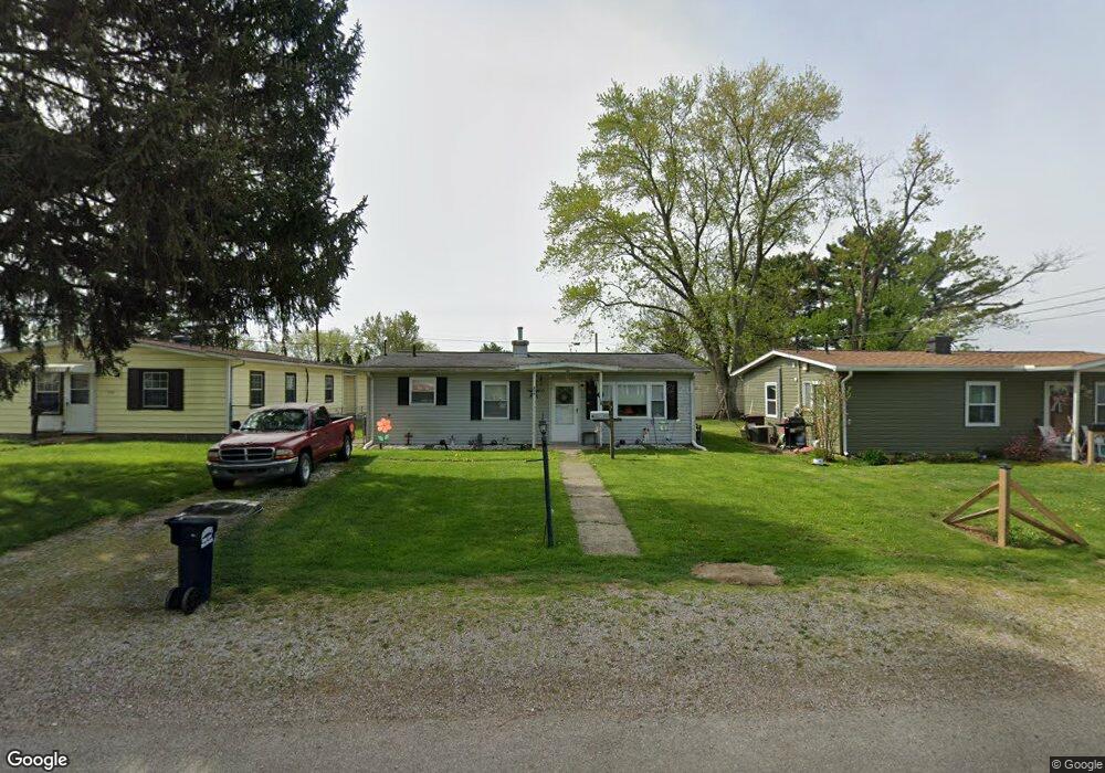
329 Cedarcrest Ave Newark, OH 43055
Estimated Value: $131,000 - $160,000
3
Beds
1
Bath
864
Sq Ft
$165/Sq Ft
Est. Value
About This Home
This home is located at 329 Cedarcrest Ave, Newark, OH 43055 and is currently estimated at $142,153, approximately $164 per square foot. 329 Cedarcrest Ave is a home located in Licking County with nearby schools including Hillview Elementary School, Heritage Middle School, and Newark High School.
Ownership History
Date
Name
Owned For
Owner Type
Purchase Details
Closed on
Jan 13, 2005
Sold by
Queen Colleen
Bought by
Lawrence Karen S
Current Estimated Value
Home Financials for this Owner
Home Financials are based on the most recent Mortgage that was taken out on this home.
Original Mortgage
$57,520
Outstanding Balance
$28,132
Interest Rate
5.9%
Mortgage Type
Unknown
Estimated Equity
$114,021
Purchase Details
Closed on
Apr 16, 2002
Sold by
Shrf Kevin C Freeman Pr
Bought by
Queen Colleen
Create a Home Valuation Report for This Property
The Home Valuation Report is an in-depth analysis detailing your home's value as well as a comparison with similar homes in the area
Home Values in the Area
Average Home Value in this Area
Purchase History
| Date | Buyer | Sale Price | Title Company |
|---|---|---|---|
| Lawrence Karen S | $71,900 | -- | |
| Queen Colleen | $31,000 | -- |
Source: Public Records
Mortgage History
| Date | Status | Borrower | Loan Amount |
|---|---|---|---|
| Open | Lawrence Karen S | $57,520 | |
| Closed | Lawrence Karen S | $10,785 |
Source: Public Records
Tax History
| Year | Tax Paid | Tax Assessment Tax Assessment Total Assessment is a certain percentage of the fair market value that is determined by local assessors to be the total taxable value of land and additions on the property. | Land | Improvement |
|---|---|---|---|---|
| 2025 | $1,192 | $32,450 | $7,490 | $24,960 |
| 2024 | $1,161 | $32,450 | $7,490 | $24,960 |
| 2023 | $1,159 | $32,450 | $7,490 | $24,960 |
| 2022 | $895 | $22,230 | $5,810 | $16,420 |
| 2021 | $938 | $22,230 | $5,810 | $16,420 |
| 2020 | $960 | $22,230 | $5,810 | $16,420 |
| 2019 | $768 | $17,120 | $4,480 | $12,640 |
| 2018 | $769 | $0 | $0 | $0 |
| 2017 | $976 | $0 | $0 | $0 |
| 2016 | $1,189 | $0 | $0 | $0 |
| 2015 | $1,215 | $0 | $0 | $0 |
| 2014 | $1,556 | $0 | $0 | $0 |
| 2013 | $1,153 | $0 | $0 | $0 |
Source: Public Records
Map
Nearby Homes
- 205 Hunter St
- 194 Fielde Dr
- 167 Fielde Dr
- 239 N Cedar St
- 75 Gay St
- 167 Essex St
- 30 N Morris St
- 397 Arlington Ave
- 468 Garfield Ave
- 417 Tuscarawas St
- 31 S Webb St
- 112 Oakwood Ave
- 331 Eastern Ave
- 494 E Main St
- 738 N Buena Vista St
- 62 Mill St
- 311 Clinton St
- 12 E Saint Clair St
- 214-218 Hudson Ave
- 252 Fleek Ave
- 333 Cedarcrest Ave
- 323 Cedarcrest Ave
- 319 Cedarcrest Ave
- 341 Cedarcrest Ave
- 313 Cedarcrest Ave
- 344 Clarendon St
- 340 Clarendon St
- 354 Clarendon St
- 324-326 Cedarcrest Ave
- 324 Cedarcrest Ave
- 347 Cedarcrest Ave
- 309 Cedarcrest Ave
- 330 Cedarcrest Ave
- 320 Cedarcrest Ave
- 334 Clarendon St
- 351 Cedarcrest Ave
- 310 Cedarcrest Ave
- 305 Cedarcrest Ave
- 360 Clarendon St
- 370 Clarendon St
Your Personal Tour Guide
Ask me questions while you tour the home.