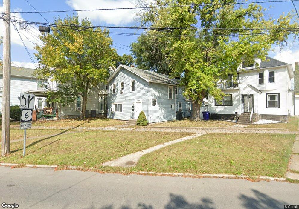
330 Huron Ave Sandusky, OH 44870
Estimated Value: $127,000 - $180,000
4
Beds
2
Baths
2,330
Sq Ft
$68/Sq Ft
Est. Value
About This Home
This home is located at 330 Huron Ave, Sandusky, OH 44870 and is currently estimated at $158,006, approximately $67 per square foot. 330 Huron Ave is a home located in Erie County with nearby schools including Sandusky High School, Monroe Preparatory Academy, and Sandusky Central Catholic School.
Ownership History
Date
Name
Owned For
Owner Type
Purchase Details
Closed on
Dec 2, 2022
Sold by
Demeulemeester Sandra and Demeulemeester Sandra G
Bought by
North View Properties Llc
Current Estimated Value
Purchase Details
Closed on
Oct 26, 1999
Sold by
Bankieris Eric E
Bought by
Ott Ronan E and Ott Elizabeth L
Home Financials for this Owner
Home Financials are based on the most recent Mortgage that was taken out on this home.
Original Mortgage
$62,500
Interest Rate
7.91%
Mortgage Type
New Conventional
Create a Home Valuation Report for This Property
The Home Valuation Report is an in-depth analysis detailing your home's value as well as a comparison with similar homes in the area
Home Values in the Area
Average Home Value in this Area
Purchase History
| Date | Buyer | Sale Price | Title Company |
|---|---|---|---|
| North View Properties Llc | -- | None Listed On Document | |
| Demeulemeester Sandra | -- | None Listed On Document | |
| Ott Ronan E | $40,000 | -- |
Source: Public Records
Mortgage History
| Date | Status | Borrower | Loan Amount |
|---|---|---|---|
| Previous Owner | Ott Ronan E | $62,500 |
Source: Public Records
Tax History
| Year | Tax Paid | Tax Assessment Tax Assessment Total Assessment is a certain percentage of the fair market value that is determined by local assessors to be the total taxable value of land and additions on the property. | Land | Improvement |
|---|---|---|---|---|
| 2025 | $1,510 | $38,699 | $3,731 | $34,968 |
| 2024 | $1,510 | $38,699 | $3,731 | $34,968 |
| 2023 | $1,524 | $26,344 | $2,947 | $23,397 |
| 2022 | $1,336 | $26,344 | $2,947 | $23,397 |
| 2021 | $1,348 | $26,350 | $2,950 | $23,400 |
| 2020 | $1,399 | $25,140 | $2,950 | $22,190 |
| 2019 | $1,439 | $25,140 | $2,950 | $22,190 |
| 2018 | $1,440 | $25,140 | $2,950 | $22,190 |
| 2017 | $1,371 | $23,860 | $3,440 | $20,420 |
| 2016 | $1,371 | $23,860 | $3,440 | $20,420 |
| 2015 | $1,242 | $23,860 | $3,440 | $20,420 |
| 2014 | $1,176 | $22,730 | $3,440 | $19,290 |
| 2013 | $1,164 | $22,730 | $3,440 | $19,290 |
Source: Public Records
Map
Nearby Homes
- 403 E Adams St
- 522 Hancock St
- 519 Huron Ave
- 526 Hancock St
- 426 Warren St
- 628 Hancock St
- 715 Wayne St
- 516 W Washington St
- 610 W Washington St
- 415 W Water St
- 412 W Shoreline Dr
- 613 W Washington St
- 801 Hayes Ave
- 528 Central Ave
- 39 Zachary Dr S
- 401 W Shoreline Dr Unit 312
- 401 W Shoreline Dr Unit 234
- 401 W Shoreline Dr Unit 367
- 401 W Shoreline Dr Unit 267
- 401 W Shoreline Dr Unit 347
- 326 Huron Ave
- 326 Huron Ave Unit 3
- 336 Huron Ave
- 322 Huron Ave
- 321 Hancock St
- 325 Hancock St
- 327 Hancock St
- 315 Hancock St
- 218 Washington Ct
- 226 Washington Ct
- 214 E Washington St
- 234 Washington Ct
- 330 Hancock St
- 334 Hancock St
- 411 Huron Ave
- 316 Hancock St
- 322 Hancock St
- 318 Hancock St
- 314 Hancock St
- 310 Hancock St
Your Personal Tour Guide
Ask me questions while you tour the home.