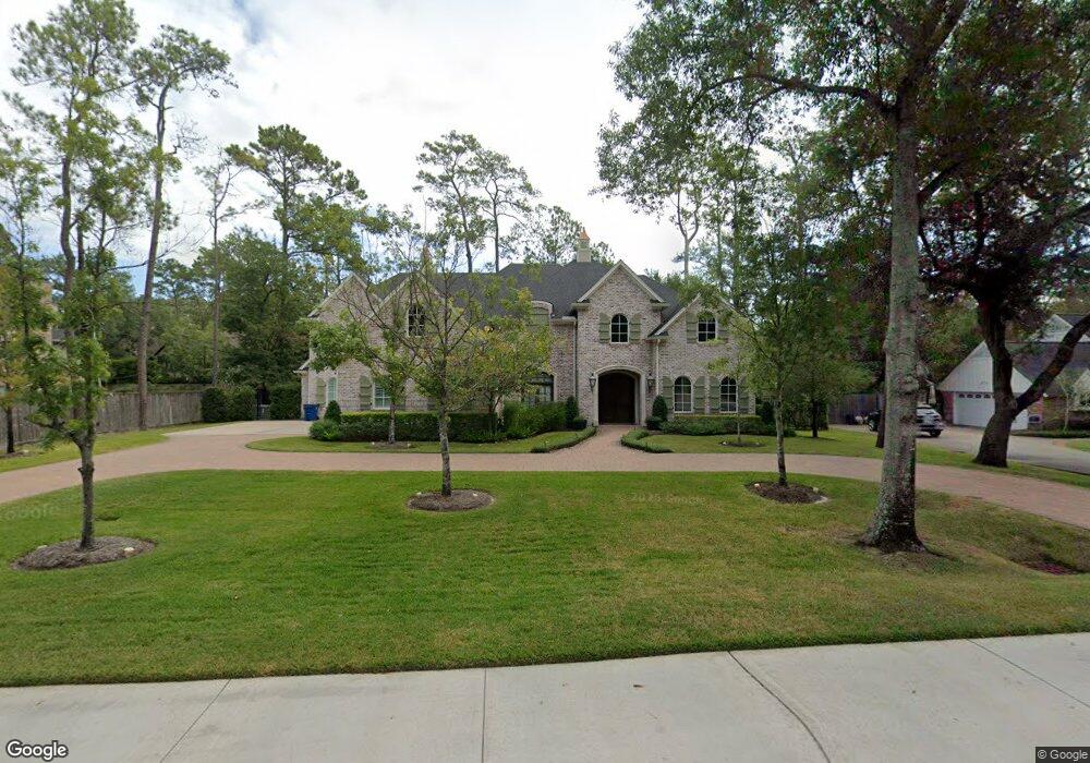
330 Knipp Rd Houston, TX 77024
Estimated Value: $2,729,000 - $3,516,000
6
Beds
7
Baths
6,153
Sq Ft
$513/Sq Ft
Est. Value
About This Home
This home is located at 330 Knipp Rd, Houston, TX 77024 and is currently estimated at $3,157,571, approximately $513 per square foot. 330 Knipp Rd is a home located in Harris County with nearby schools including Frostwood Elementary School, Memorial Middle, and Memorial High School.
Ownership History
Date
Name
Owned For
Owner Type
Purchase Details
Closed on
Jul 31, 2001
Sold by
Jordan Neal F and Jordan Vaida M
Bought by
Pong Allen D
Current Estimated Value
Home Financials for this Owner
Home Financials are based on the most recent Mortgage that was taken out on this home.
Original Mortgage
$440,000
Outstanding Balance
$170,396
Interest Rate
7.05%
Estimated Equity
$2,987,175
Purchase Details
Closed on
Jul 17, 1998
Sold by
Towler Sarah E
Bought by
Jordan Neal F
Purchase Details
Closed on
Dec 20, 1997
Sold by
Jordan Kirk G
Bought by
Jordan Neal F
Purchase Details
Closed on
Sep 27, 1993
Sold by
Jordan Neal F
Bought by
Towler Sarah E
Create a Home Valuation Report for This Property
The Home Valuation Report is an in-depth analysis detailing your home's value as well as a comparison with similar homes in the area
Home Values in the Area
Average Home Value in this Area
Purchase History
| Date | Buyer | Sale Price | Title Company |
|---|---|---|---|
| Pong Allen D | -- | -- | |
| Jordan Neal F | -- | -- | |
| Jordan Neal F | -- | -- | |
| Towler Sarah E | -- | -- | |
| Jordan Kirk G | -- | -- |
Source: Public Records
Mortgage History
| Date | Status | Borrower | Loan Amount |
|---|---|---|---|
| Open | Pong Allen D | $440,000 |
Source: Public Records
Tax History
| Year | Tax Paid | Tax Assessment Tax Assessment Total Assessment is a certain percentage of the fair market value that is determined by local assessors to be the total taxable value of land and additions on the property. | Land | Improvement |
|---|---|---|---|---|
| 2025 | $38,753 | $2,987,793 | $1,094,553 | $1,893,240 |
| 2024 | $38,753 | $2,460,000 | $1,058,068 | $1,401,932 |
| 2023 | $38,753 | $2,566,906 | $1,003,340 | $1,563,566 |
| 2022 | $47,803 | $2,658,431 | $1,003,340 | $1,655,091 |
| 2021 | $45,262 | $2,090,000 | $948,613 | $1,141,387 |
| 2020 | $45,996 | $2,076,875 | $948,613 | $1,128,262 |
| 2019 | $50,846 | $2,204,287 | $948,613 | $1,255,674 |
| 2018 | $11,615 | $2,285,778 | $948,613 | $1,337,165 |
| 2017 | $59,426 | $2,714,078 | $948,613 | $1,765,465 |
| 2016 | $24,065 | $1,281,548 | $948,613 | $332,935 |
| 2015 | $16,235 | $1,281,548 | $948,613 | $332,935 |
| 2014 | $16,235 | $1,094,082 | $820,915 | $273,167 |
Source: Public Records
Map
Nearby Homes
- 318 Knipp Rd
- 345 Knipp Rd
- 9 Valley Forge Dr
- 8 Greyton Ln
- 26 Valley Forge Dr
- 11840 Stuckey Ln
- 5 Rip Van Winkle Ln
- 11739 Wood Ln
- 11909 Knippwood Ln
- 11921 Knippwood Ln
- 15 Lorrielake Ln
- 6 Heritage Ct
- 15 Sandalwood Dr
- 601 Strey Ln
- 230 Gessner Rd
- 11711 Memorial Dr Unit 659
- 11711 Memorial Dr Unit 271
- 11711 Memorial Dr Unit 41
- 11711 Memorial Dr Unit 534
- 11711 Memorial Dr Unit 105
- 326 Knipp Rd
- 331 Chapel Belle Ln
- 11821 Balmoral Ln
- 327 Chapel Belle Ln
- 331 Knipp Rd
- 322 Knipp Rd
- 323 Knipp Rd
- 335 Knipp Rd
- 323 Chapel Belle Ln
- 338 Knipp Rd
- 335 Chapel Belle Ln
- 330 Chapel Belle Ln
- 11903 Stoney Ridge Ln
- 321 Knipp Rd
- 326 Chapel Belle Ln
- 334 Chapel Belle Ln
- 311 Knipp Forest St
- 319 Chapel Belle Ln
- 343 Knipp Forest St
- 322 Chapel Belle Ln
Your Personal Tour Guide
Ask me questions while you tour the home.