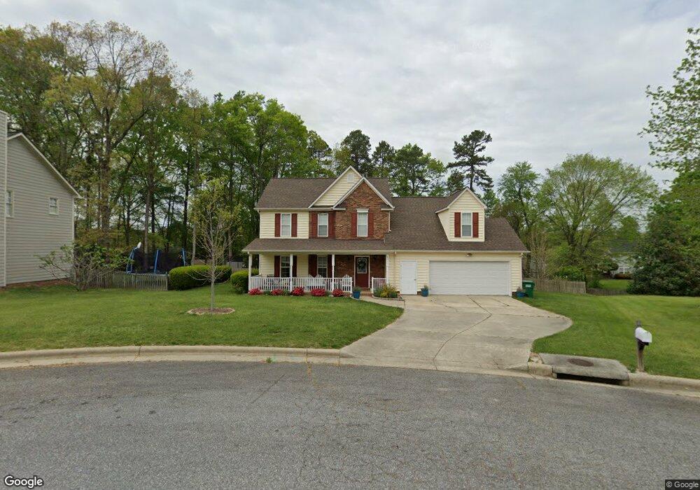
3311 Sparrowhawk Dr High Point, NC 27265
Bent Tree NeighborhoodEstimated Value: $328,000 - $360,000
4
Beds
3
Baths
2,169
Sq Ft
$158/Sq Ft
Est. Value
About This Home
This home is located at 3311 Sparrowhawk Dr, High Point, NC 27265 and is currently estimated at $342,908, approximately $158 per square foot. 3311 Sparrowhawk Dr is a home located in Guilford County with nearby schools including Southwest Elementary School, Southwest Guilford Middle School, and Southwest Guilford High School.
Ownership History
Date
Name
Owned For
Owner Type
Purchase Details
Closed on
Jul 12, 2013
Sold by
Byrne Denis
Bought by
Meixner Brian D and Meixner Audrey M
Current Estimated Value
Home Financials for this Owner
Home Financials are based on the most recent Mortgage that was taken out on this home.
Original Mortgage
$146,400
Outstanding Balance
$106,814
Interest Rate
4%
Mortgage Type
New Conventional
Estimated Equity
$236,094
Purchase Details
Closed on
Mar 20, 2002
Sold by
Blanchard Jeanette T and Blanchard Steven Paul
Bought by
Byrne Denis
Home Financials for this Owner
Home Financials are based on the most recent Mortgage that was taken out on this home.
Original Mortgage
$146,200
Interest Rate
6.86%
Create a Home Valuation Report for This Property
The Home Valuation Report is an in-depth analysis detailing your home's value as well as a comparison with similar homes in the area
Home Values in the Area
Average Home Value in this Area
Purchase History
We collect this data history from publicly available records. To have your information removed, we recommend requesting removal directly through your county’s website.
| Date | Buyer | Sale Price | Title Company |
|---|---|---|---|
| Meixner Brian D | $183,000 | None Available | |
| Byrne Denis | $154,000 | -- |
Source: Public Records
Mortgage History
We collect this data history from publicly available records. To have your information removed, we recommend requesting removal directly through your county’s website.
| Date | Status | Borrower | Loan Amount |
|---|---|---|---|
| Open | Meixner Brian D | $146,400 | |
| Previous Owner | Byrne Denis | $146,200 |
Source: Public Records
Tax History
| Year | Tax Paid | Tax Assessment Tax Assessment Total Assessment is a certain percentage of the fair market value that is determined by local assessors to be the total taxable value of land and additions on the property. | Land | Improvement |
|---|---|---|---|---|
| 2025 | $3,448 | $250,200 | $44,000 | $206,200 |
| 2024 | $3,448 | $250,200 | $44,000 | $206,200 |
| 2023 | $3,448 | $250,200 | $44,000 | $206,200 |
| 2022 | $3,373 | $250,200 | $44,000 | $206,200 |
| 2021 | $2,622 | $190,300 | $35,000 | $155,300 |
| 2020 | $2,622 | $190,300 | $35,000 | $155,300 |
| 2019 | $2,622 | $190,300 | $0 | $0 |
| 2018 | $2,609 | $190,300 | $0 | $0 |
| 2017 | $2,609 | $190,300 | $0 | $0 |
| 2016 | $2,523 | $179,900 | $0 | $0 |
| 2015 | $2,537 | $179,900 | $0 | $0 |
| 2014 | $2,580 | $179,900 | $0 | $0 |
Source: Public Records
Map
Nearby Homes
- 3337 Timberwolf Ave
- 3401 Timberwolf Ave
- 1517 Skeet Club Rd
- 4012 Berkshire Ct
- 3023 Maple Branch Dr
- 3905 Wynne Brook Ct
- 3696 Waterford Oak Ct
- 3421 Wildwood Ave
- 2989 Maple Branch Dr
- 3659 Canopy Oak Ct
- 3625 Oak Chase Dr
- 3701 Village Springs Dr
- 3273 Alyssa Way
- 4072 Fountain Grove Dr
- 3744 Deerfield St
- 3779 Shadow Ridge Dr
- 4353 Thistle Down Ct
- 3208 Riley Ford Trail
- 4413 Edbury Ct
- 3840 Thistleberry Rd
- 3309 Sparrowhawk Dr
- 3310 Timberwolf Ave
- 3312 Timberwolf Ave
- 3308 Timberwolf Ave
- 3307 Sparrowhawk Dr
- 3312 Sparrowhawk Dr
- 3314 Timberwolf Ave
- 3306 Timberwolf Ave
- 3305 Sparrowhawk Dr
- 3310 Sparrowhawk Dr
- 3318 Timberwolf Ave
- 3308 Sparrowhawk Dr
- 3322 Timberwolf Ave
- 3306 Sparrowhawk Dr
- 3304 Timberwolf Ave
- 3326 Timberwolf Ave
- 3330 Timberwolf Ave
- 3304 Sparrowhawk Dr
- 3303 Sparrowhawk Dr
- 3334 Timberwolf Ave
Your Personal Tour Guide
Ask me questions while you tour the home.