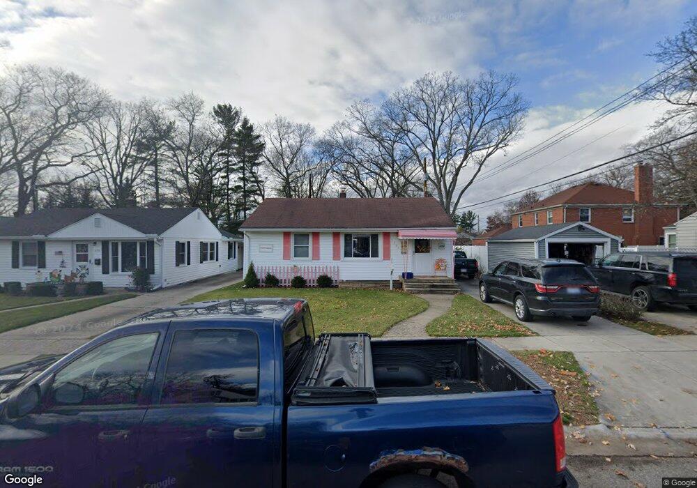
3329 Walnut St Port Huron, MI 48060
Estimated Value: $155,000 - $168,000
2
Beds
1
Bath
1,000
Sq Ft
$163/Sq Ft
Est. Value
About This Home
This home is located at 3329 Walnut St, Port Huron, MI 48060 and is currently estimated at $162,775, approximately $162 per square foot. 3329 Walnut St is a home located in St. Clair County with nearby schools including Garfield Elementary School, Holland Woods Middle School, and Port Huron Northern High School.
Ownership History
Date
Name
Owned For
Owner Type
Purchase Details
Closed on
May 27, 2016
Sold by
Lb Homes Llc
Bought by
Landschoot Donna J
Current Estimated Value
Home Financials for this Owner
Home Financials are based on the most recent Mortgage that was taken out on this home.
Original Mortgage
$52,000
Outstanding Balance
$41,507
Interest Rate
3.66%
Mortgage Type
New Conventional
Estimated Equity
$121,268
Purchase Details
Closed on
May 20, 2013
Sold by
Furstenau Stephan
Bought by
Lb Homes Llc
Purchase Details
Closed on
Sep 17, 2012
Sold by
Westrick Gary
Bought by
Furstenau Stephan
Purchase Details
Closed on
Mar 22, 2012
Sold by
Westrick Gary F
Bought by
Taylor Sandra
Create a Home Valuation Report for This Property
The Home Valuation Report is an in-depth analysis detailing your home's value as well as a comparison with similar homes in the area
Home Values in the Area
Average Home Value in this Area
Purchase History
| Date | Buyer | Sale Price | Title Company |
|---|---|---|---|
| Landschoot Donna J | $65,000 | None Available | |
| Lb Homes Llc | -- | None Available | |
| Furstenau Stephan | $18,991 | None Available | |
| Taylor Sandra | $17,661 | None Available |
Source: Public Records
Mortgage History
| Date | Status | Borrower | Loan Amount |
|---|---|---|---|
| Open | Landschoot Donna J | $52,000 |
Source: Public Records
Tax History
| Year | Tax Paid | Tax Assessment Tax Assessment Total Assessment is a certain percentage of the fair market value that is determined by local assessors to be the total taxable value of land and additions on the property. | Land | Improvement |
|---|---|---|---|---|
| 2025 | $2,061 | $70,600 | $0 | $0 |
| 2024 | $2,010 | $64,200 | $0 | $0 |
| 2023 | $1,898 | $56,900 | $0 | $0 |
| 2022 | $2,002 | $50,800 | $0 | $0 |
| 2020 | $1,922 | $45,800 | $45,800 | $0 |
| 2019 | $1,888 | $39,700 | $0 | $0 |
| 2018 | $1,846 | $39,700 | $0 | $0 |
| 2017 | $1,648 | $36,200 | $0 | $0 |
| 2016 | $1,132 | $36,200 | $0 | $0 |
| 2015 | $1,599 | $32,200 | $32,200 | $0 |
| 2014 | $1,599 | $29,700 | $29,700 | $0 |
| 2013 | -- | $29,100 | $0 | $0 |
Source: Public Records
Map
Nearby Homes
- 817 Florida Ave
- 3513 Stone St
- 3455 Gratiot Ave
- 810 Holland Ave Unit 2
- 3165 10th Ave
- 3142 Wright St
- 2915 10th Ave
- 1211 Myrtle St
- 910 Church St
- 2835 17th Ave
- 3218 Monticello Dr
- 2308 Brandywine Ln
- 2400 Stone St Unit 2414
- 2215 Hancock St
- 2525 19th Ave
- 4033 Helen Ave
- 4055 Velma Dr
- 3515 Strawberry Ln
- 2515 Woodstock Dr
- 1803 10th Ave
- 3325 Walnut St
- 3307 Walnut St
- 1002 Edison Blvd
- 1012 Edison Blvd
- 1018 Edison Blvd
- 918 Edison Blvd
- 3320 Walnut St
- 3318 Walnut St
- 3324 Walnut St
- 3318 Stone St
- 3314 Walnut St Unit Bldg-Unit
- 3314 Walnut St
- 1024 Edison Blvd
- 1001 Edison Blvd
- 3320 Stone St
- 3316 Stone St
- 1005 Sanborn St
- 1001 Sanborn St
- 3330 Stone St
- 1013 Sanborn St
Your Personal Tour Guide
Ask me questions while you tour the home.