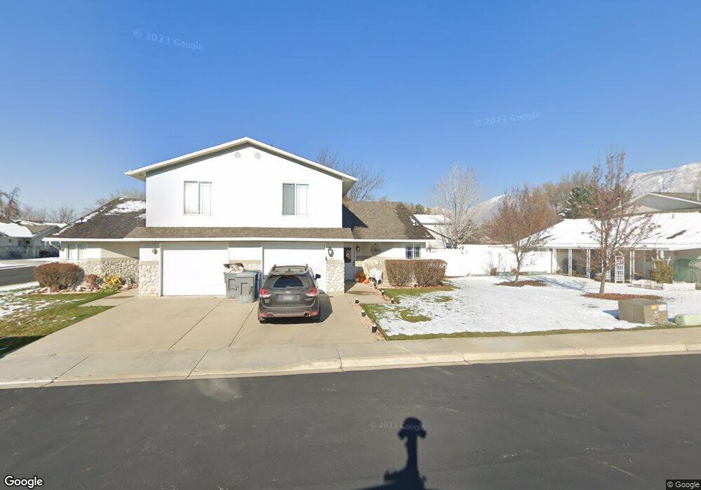
333 E 30 N American Fork, UT 84003
Estimated Value: $364,000 - $381,000
2
Beds
2
Baths
1,359
Sq Ft
$272/Sq Ft
Est. Value
About This Home
This home is located at 333 E 30 N, American Fork, UT 84003 and is currently estimated at $369,674, approximately $272 per square foot. 333 E 30 N is a home located in Utah County with nearby schools including Forbes Elementary School, American Fork Junior High School, and American Fork High School.
Ownership History
Date
Name
Owned For
Owner Type
Purchase Details
Closed on
Jan 18, 2016
Sold by
Pulsipher Brandon
Bought by
Pulsipher Brandon V and Pulsipher Jacqueline J
Current Estimated Value
Purchase Details
Closed on
May 3, 2011
Sold by
Mayberry Cherry Lynn
Bought by
Pulsipher Brandon
Purchase Details
Closed on
Mar 15, 2005
Sold by
Dean Cherry C
Bought by
Mayberry Cherry Lynn
Purchase Details
Closed on
Aug 6, 1998
Sold by
Dean Cherry C
Bought by
Dean Cherry C
Home Financials for this Owner
Home Financials are based on the most recent Mortgage that was taken out on this home.
Original Mortgage
$79,000
Interest Rate
6.93%
Purchase Details
Closed on
Feb 28, 1997
Sold by
Dean Cherry C
Bought by
Dean Cherry C
Home Financials for this Owner
Home Financials are based on the most recent Mortgage that was taken out on this home.
Original Mortgage
$77,000
Interest Rate
7.86%
Create a Home Valuation Report for This Property
The Home Valuation Report is an in-depth analysis detailing your home's value as well as a comparison with similar homes in the area
Home Values in the Area
Average Home Value in this Area
Purchase History
We collect this data history from publicly available records. To have your information removed, we recommend requesting removal directly through your county’s website.
| Date | Buyer | Sale Price | Title Company |
|---|---|---|---|
| Pulsipher Brandon V | -- | None Available | |
| Pulsipher Brandon | -- | Access Title Company | |
| Mayberry Cherry Lynn | -- | Accommodation | |
| Dean Cherry C | -- | -- | |
| Dean Cherry C | -- | -- |
Source: Public Records
Mortgage History
We collect this data history from publicly available records. To have your information removed, we recommend requesting removal directly through your county’s website.
| Date | Status | Borrower | Loan Amount |
|---|---|---|---|
| Previous Owner | Dean Cherry C | $79,000 | |
| Previous Owner | Dean Cherry C | $77,000 |
Source: Public Records
Tax History
| Year | Tax Paid | Tax Assessment Tax Assessment Total Assessment is a certain percentage of the fair market value that is determined by local assessors to be the total taxable value of land and additions on the property. | Land | Improvement |
|---|---|---|---|---|
| 2025 | $1,788 | $200,970 | -- | -- |
| 2024 | $1,788 | $198,660 | $0 | $0 |
| 2023 | $1,694 | $199,595 | $0 | $0 |
| 2022 | $1,490 | $173,195 | $0 | $0 |
| 2021 | $1,334 | $242,200 | $80,100 | $162,100 |
| 2020 | $1,297 | $228,500 | $80,100 | $148,400 |
| 2019 | $1,164 | $212,000 | $80,100 | $131,900 |
| 2018 | $1,102 | $192,000 | $80,100 | $111,900 |
| 2017 | $1,106 | $103,950 | $0 | $0 |
| 2016 | $967 | $84,480 | $0 | $0 |
| 2015 | $989 | $81,950 | $0 | $0 |
| 2014 | $908 | $74,250 | $0 | $0 |
Source: Public Records
Map
Nearby Homes
Your Personal Tour Guide
Ask me questions while you tour the home.