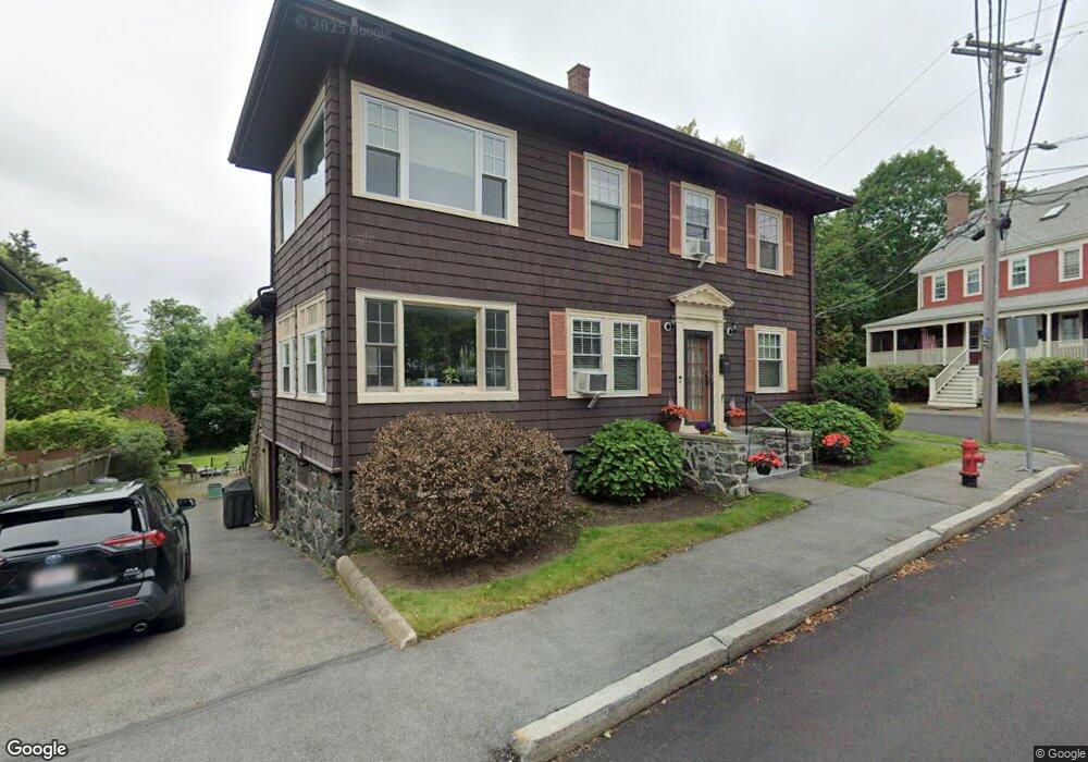
34 Phillips St Swampscott, MA 01907
Estimated Value: $545,000 - $790,000
3
Beds
3
Baths
1,566
Sq Ft
$407/Sq Ft
Est. Value
About This Home
This home is located at 34 Phillips St, Swampscott, MA 01907 and is currently estimated at $636,821, approximately $406 per square foot. 34 Phillips St is a home located in Essex County with nearby schools including Swampscott Middle School and Swampscott High School.
Ownership History
Date
Name
Owned For
Owner Type
Purchase Details
Closed on
Mar 27, 2023
Sold by
Campbell Michael S and Gill-Campbell Janet
Bought by
34 Phillips Street Rt
Current Estimated Value
Purchase Details
Closed on
Jul 14, 1995
Sold by
White Mary T and White Jon E
Bought by
Campbell Michael S and Campbell Janet Gill
Create a Home Valuation Report for This Property
The Home Valuation Report is an in-depth analysis detailing your home's value as well as a comparison with similar homes in the area
Home Values in the Area
Average Home Value in this Area
Purchase History
| Date | Buyer | Sale Price | Title Company |
|---|---|---|---|
| 34 Phillips Street Rt | -- | None Available | |
| Campbell Michael S | $161,000 | -- |
Source: Public Records
Mortgage History
| Date | Status | Borrower | Loan Amount |
|---|---|---|---|
| Previous Owner | Campbell Michael S | $200,000 | |
| Previous Owner | Campbell Michael S | $220,000 | |
| Previous Owner | Campbell Michael S | $42,000 |
Source: Public Records
Tax History
| Year | Tax Paid | Tax Assessment Tax Assessment Total Assessment is a certain percentage of the fair market value that is determined by local assessors to be the total taxable value of land and additions on the property. | Land | Improvement |
|---|---|---|---|---|
| 2025 | $5,095 | $444,200 | $0 | $444,200 |
| 2024 | $4,596 | $400,000 | $0 | $400,000 |
| 2023 | $4,302 | $366,400 | $0 | $366,400 |
| 2022 | $4,295 | $334,800 | $0 | $334,800 |
| 2021 | $4,237 | $307,000 | $0 | $307,000 |
| 2020 | $4,219 | $295,000 | $0 | $295,000 |
| 2019 | $4,036 | $265,500 | $0 | $265,500 |
| 2018 | $4,248 | $265,500 | $0 | $265,500 |
| 2017 | $4,446 | $254,800 | $0 | $254,800 |
| 2016 | $4,416 | $254,800 | $0 | $254,800 |
| 2015 | $4,126 | $240,600 | $0 | $240,600 |
| 2014 | $4,140 | $221,400 | $0 | $221,400 |
Source: Public Records
Map
Nearby Homes
- 28 Claremont Terrace Unit 6
- 100 Burrill St Unit 6
- 11 Boynton St Unit 104
- 11 Boynton St Unit 101
- 11 Boynton St Unit 103
- 11 Boynton St Unit 201
- 168 Humphrey St Unit PH
- 143 Burrill St Unit 301
- 146 Burrill St
- 49 Blaney St
- 133 Elmwood Rd Unit 2
- 27 Rockland St
- 245 Humphrey St Unit 205
- 97 Seymour Ave
- 80 Norfolk Ave Unit 1
- 106 Norfolk Ave
- 11 Phillips Ave
- 4 Valley Rd Unit 4
- 11 Seymour Ave Unit 3
- 46 Stetson Ave
- 14 Claremont Terrace
- 30 Phillips St
- 28 Claremont Terrace Unit 8
- 28 Claremont Terrace Unit 7
- 28 Claremont Terrace Unit 5
- 28 Claremont Terrace Unit 3
- 28 Claremont Terrace Unit 2
- 28 Claremont Terrace Unit 1
- 28 Claremont Terrace Unit 6a
- 28 Claremont Terrace Unit ONE
- 15 Claremont Terrace Unit 17
- 15 Claremont Terrace Unit 2
- 15 Claremont Terrace Unit 15
- 22 Claremont Terrace
- 24 Phillips St
- 24 Phillips St Unit 1
- 24 Phillips St Unit 2
- 9 Claremont Terrace
- 9 Claremont Terrace Unit 1
- 9 Claremont Terrace Unit 2
Your Personal Tour Guide
Ask me questions while you tour the home.