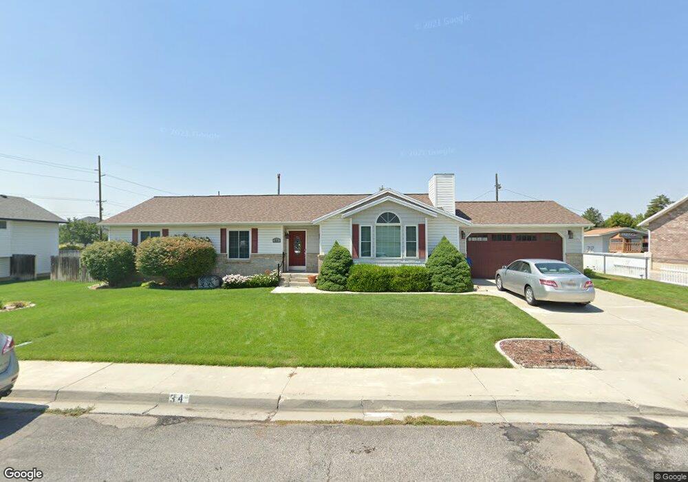
34 S 990 E American Fork, UT 84003
Estimated Value: $529,000 - $603,000
5
Beds
3
Baths
3,112
Sq Ft
$186/Sq Ft
Est. Value
About This Home
This home is located at 34 S 990 E, American Fork, UT 84003 and is currently estimated at $580,018, approximately $186 per square foot. 34 S 990 E is a home located in Utah County with nearby schools including Barratt Elementary School, American Fork Junior High School, and American Fork High School.
Ownership History
Date
Name
Owned For
Owner Type
Purchase Details
Closed on
Oct 14, 2022
Sold by
Goss Family Trust
Bought by
Holloway Dallon Leon and Holloway Danielle
Current Estimated Value
Purchase Details
Closed on
Nov 5, 2021
Sold by
Goss Family Trust and Goss Connie K
Bought by
Holloway Dallon Leon and Holloway Danielle
Home Financials for this Owner
Home Financials are based on the most recent Mortgage that was taken out on this home.
Original Mortgage
$400,000
Interest Rate
2.88%
Mortgage Type
New Conventional
Purchase Details
Closed on
Mar 25, 2021
Sold by
Goss Robert P and The Robert & Connie Goss Trust
Bought by
Goss Robert P and Goss Connie K
Purchase Details
Closed on
Feb 24, 2010
Sold by
Goss Robert
Bought by
Goss Robert P
Purchase Details
Closed on
Nov 27, 2002
Sold by
Goss Robert Pike
Bought by
Goss Robert
Home Financials for this Owner
Home Financials are based on the most recent Mortgage that was taken out on this home.
Original Mortgage
$148,800
Interest Rate
6.12%
Purchase Details
Closed on
Nov 25, 2002
Sold by
Gunnell Douglas B and Stoddard Kim Gunnell
Bought by
Goss Robert Pike
Home Financials for this Owner
Home Financials are based on the most recent Mortgage that was taken out on this home.
Original Mortgage
$148,800
Interest Rate
6.12%
Purchase Details
Closed on
Nov 22, 2002
Sold by
Gunnell Douglas B and Stoddard Kim Gunnell
Bought by
Goss Robert Pike
Home Financials for this Owner
Home Financials are based on the most recent Mortgage that was taken out on this home.
Original Mortgage
$148,800
Interest Rate
6.12%
Purchase Details
Closed on
Feb 24, 2000
Sold by
Gunnell Douglas B
Bought by
Gunnell Douglas B and The Douglas B Gunnell Revocable Living T
Purchase Details
Closed on
Sep 30, 1997
Sold by
Norton Jr Oak D and Norton Gail C
Bought by
Gunnell Douglas B and Gunnell Kim N
Home Financials for this Owner
Home Financials are based on the most recent Mortgage that was taken out on this home.
Original Mortgage
$120,000
Interest Rate
7.49%
Create a Home Valuation Report for This Property
The Home Valuation Report is an in-depth analysis detailing your home's value as well as a comparison with similar homes in the area
Home Values in the Area
Average Home Value in this Area
Purchase History
| Date | Buyer | Sale Price | Title Company |
|---|---|---|---|
| Holloway Dallon Leon | -- | Rudd & Hawkes Title | |
| Holloway Dallon Leon | -- | Rudd & Hawkes Title | |
| Goss Robert P | -- | None Available | |
| Goss Robert P | -- | Richland Title Insurance Ag | |
| Goss Robert | -- | Guardian Title | |
| Goss Robert Pike | -- | Metro National Title | |
| Goss Robert Pike | -- | Metro National Title | |
| Gunnell Douglas B | -- | -- | |
| Gunnell Douglas B | -- | -- |
Source: Public Records
Mortgage History
| Date | Status | Borrower | Loan Amount |
|---|---|---|---|
| Previous Owner | Holloway Dallon Leon | $400,000 | |
| Previous Owner | Goss Robert | $148,800 | |
| Previous Owner | Gunnell Douglas B | $120,000 |
Source: Public Records
Tax History
| Year | Tax Paid | Tax Assessment Tax Assessment Total Assessment is a certain percentage of the fair market value that is determined by local assessors to be the total taxable value of land and additions on the property. | Land | Improvement |
|---|---|---|---|---|
| 2025 | $2,561 | $306,130 | -- | -- |
| 2024 | $2,561 | $284,570 | $0 | $0 |
| 2023 | $2,391 | $281,710 | $0 | $0 |
| 2022 | $2,545 | $295,900 | $0 | $0 |
| 2021 | $2,179 | $395,600 | $145,400 | $250,200 |
| 2020 | $2,040 | $359,300 | $129,800 | $229,500 |
| 2019 | $1,889 | $344,000 | $120,600 | $223,400 |
| 2018 | $1,767 | $307,800 | $113,500 | $194,300 |
| 2017 | $1,620 | $152,240 | $0 | $0 |
| 2016 | $1,687 | $147,345 | $0 | $0 |
| 2015 | $1,611 | $133,485 | $0 | $0 |
| 2014 | $1,546 | $126,390 | $0 | $0 |
Source: Public Records
Map
Nearby Homes
Your Personal Tour Guide
Ask me questions while you tour the home.