
Seller's Agent in 2026
Mike Olivas
ClearView Realty
(915) 497-0610
1 in this area
42 Total Sales
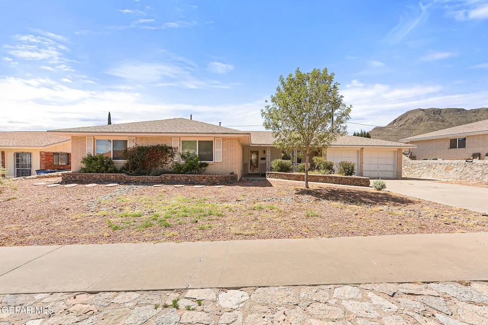


Charming Home with Stunning Mountain Views
This beautifully maintained 3-bedroom, 2-bathroom home offering 1,802 sq. ft. of living space in a peaceful Northeast El Paso neighborhood. Perfectly situated against the breathtaking backdrop of the Franklin Mountains, this home combines comfort, style, and location. Step inside to find a spacious, light-filled layout with a warm and inviting atmosphere. The living and dining areas flow seamlessly, creating the ideal space for both relaxation and entertaining. The well-appointed kitchen offers ample cabinetry and counter space, perfect for everyday meals or hosting gatherings. The primary suite provides a private retreat with its own ensuite bathroom, while two additional bedrooms are generously sized and versatile for family, guests, or a home office. Outside, enjoy your own slice of El Paso's natural beauty—whether it's sipping your morning coffee on the patio or hosting summer cookouts, the mountain views will never disappoint.
| Date | Type | Sale Price | Title Company |
|---|---|---|---|
| Warranty Deed | -- | El Paso Clear Title | |
| Warranty Deed | -- | None Listed On Document | |
| Interfamily Deed Transfer | -- | None Available | |
| Interfamily Deed Transfer | -- | Sierra Title Company | |
| Interfamily Deed Transfer | -- | -- | |
| Warranty Deed | -- | -- |
| Date | Event | Price | List to Sale | Price per Sq Ft |
|---|---|---|---|---|
| 01/30/2026 01/30/26 | Sold | -- | -- | -- |
| 01/10/2026 01/10/26 | Pending | -- | -- | -- |
| 09/19/2025 09/19/25 | For Sale | $254,950 | -- | $141 / Sq Ft |
| Year | Tax Paid | Tax Assessment Tax Assessment Total Assessment is a certain percentage of the fair market value that is determined by local assessors to be the total taxable value of land and additions on the property. | Land | Improvement |
|---|---|---|---|---|
| 2025 | $3,993 | $217,544 | -- | -- |
| 2024 | $3,993 | $197,767 | -- | -- |
| 2023 | $3,993 | $179,788 | -- | -- |
| 2022 | $4,838 | $163,444 | $0 | $0 |
| 2021 | $4,639 | $148,585 | $15,681 | $132,904 |
| 2020 | $4,245 | $138,107 | $15,681 | $122,426 |
| 2018 | $3,996 | $135,005 | $15,681 | $119,324 |
| 2017 | $3,556 | $126,255 | $15,681 | $110,574 |
| 2016 | $3,556 | $126,255 | $15,681 | $110,574 |
| 2015 | $3,210 | $126,255 | $15,681 | $110,574 |
| 2014 | $3,210 | $126,202 | $15,681 | $110,521 |
Seller's Agent in 2026
Mike Olivas
ClearView Realty
(915) 497-0610
1 in this area
42 Total Sales
Buyer's Agent in 2026
Estela Stephan
MRG REALTY LLC
(915) 282-6291
1 in this area
85 Total Sales
Source: Greater El Paso Association of REALTORS®
MLS Number: 930500
APN: M757-999-0060-5700
Disclaimer: Certain information contained herein is derived from information provided by parties other than Homes.com. All information provided is deemed reliable, but is not guaranteed to be accurate and should be independently verified.
![]() The data relating to real estate for sale on this web site comes in part from the IDX Program of the Greater El Paso Association of REALTORS®. Real estate listings held by brokerage firms other than Ten-X are marked with the IDX logo or the IDX thumbnail logo and detailed information about them includes the name of the listing brokers.
The data relating to real estate for sale on this web site comes in part from the IDX Program of the Greater El Paso Association of REALTORS®. Real estate listings held by brokerage firms other than Ten-X are marked with the IDX logo or the IDX thumbnail logo and detailed information about them includes the name of the listing brokers.
Listing data is deemed reliable but not guaranteed.
Copyright 2026 the Greater El Paso Association of REALTORS®, MLS Inc. All rights reserved.
Ask me questions while you tour the home.