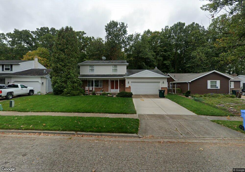
3435 Gingersnap Ln Lansing, MI 48911
Averill Woods NeighborhoodEstimated Value: $212,000 - $270,000
About This Home
This home is located at 3435 Gingersnap Ln, Lansing, MI 48911 and is currently estimated at $237,031, approximately $86 per square foot. 3435 Gingersnap Ln is a home located in Ingham County with nearby schools including Averill Elementary School, Attwood School, and J.W. Sexton High School.
Ownership History
We collect this data history from publicly available records. To have your information removed, we recommend requesting removal directly through your county’s website.
Purchase Details
Purchase Details
Home Financials for this Owner
Home Financials are based on the most recent Mortgage that was taken out on this home.Home Values in the Area
Average Home Value in this Area
Purchase History
We collect this data history from publicly available records. To have your information removed, we recommend requesting removal directly through your county’s website.
| Date | Buyer | Sale Price | Title Company |
|---|---|---|---|
| $78,534 | None Available | ||
| $159,000 | Tri County |
Mortgage History
We collect this data history from publicly available records. To have your information removed, we recommend requesting removal directly through your county’s website.
| Date | Status | Borrower | Loan Amount |
|---|---|---|---|
| Previous Owner | $135,150 |
Tax History
We collect this data history from publicly available records. To have your information removed, we recommend requesting removal directly through your county’s website.
| Year | Tax Paid | Tax Assessment Tax Assessment Total Assessment is a certain percentage of the fair market value that is determined by local assessors to be the total taxable value of land and additions on the property. | Land | Improvement |
|---|---|---|---|---|
| 2025 | $2,903 | $105,500 | $11,200 | $94,300 |
| 2024 | $28 | $102,500 | $11,200 | $91,300 |
| 2023 | $3,311 | $88,900 | $11,200 | $77,700 |
| 2022 | $2,983 | $80,800 | $11,200 | $69,600 |
| 2021 | $2,921 | $77,200 | $10,500 | $66,700 |
| 2020 | $2,904 | $72,000 | $10,500 | $61,500 |
| 2019 | $2,784 | $64,100 | $10,500 | $53,600 |
| 2018 | $2,608 | $56,200 | $10,500 | $45,700 |
| 2017 | $2,497 | $56,200 | $10,500 | $45,700 |
| 2016 | $2,388 | $49,900 | $10,500 | $39,400 |
| 2015 | $2,388 | $45,600 | $21,076 | $24,524 |
| 2014 | $2,388 | $42,600 | $21,076 | $21,524 |
Map
- 3618 Malibu Dr
- 3712 Malibu Dr
- 3601 Christine Dr
- 3305 Inverary Dr
- 3201 Norwich Rd
- 2 Locust Ln
- 0 S Deerfield Ave
- 3407 Churchill Ave
- 3012 Ingham St
- 3536 Oakmont Dr Unit 60
- 3122 Ingham St
- 2525 Bedford Rd
- 3721 Kendalwood Dr
- 3630 Brighton Dr
- 3901 Kendalwood Dr
- 3601 Muirfield Dr
- 0 Dunlap St
- 3924 Wedgewood Dr
- 3812 Wainwright Ave
- 2409 Victor Ave
- 3501 Gingersnap Ln
- 3429 Gingersnap Ln
- 3507 Ginger Snap Ln
- 3507 Gingersnap Ln
- 3507 Ginger
- 3423 Gingersnap Ln
- 3513 Gingersnap Ln
- 3432 Gingersnap Ln
- 3500 Gingersnap Ln
- 3500 Ginger
- 3426 Gingersnap Ln
- 3417 Gingersnap Ln
- 3506 Gingersnap Ln
- 3519 Ginger Snap Ln
- 3420 Gingersnap Ln
- 3519 Gingersnap Ln
- 3420 Ginger Snap Ln
- 3512 Gingersnap Ln
- 3411 Gingersnap Ln
- 3525 Gingersnap Ln
Ask me questions while you tour the home.