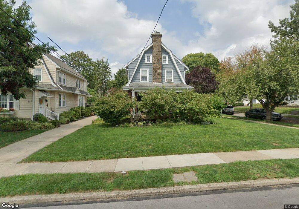
344 Lenox Rd Havertown, PA 19083
Estimated Value: $511,787 - $616,000
About This Home
This home is located at 344 Lenox Rd, Havertown, PA 19083 and is currently estimated at $550,697, approximately $345 per square foot. 344 Lenox Rd is a home located in Delaware County with nearby schools including Chatham Park Elementary School, Haverford Middle School, and Haverford Senior High School.
Ownership History
We collect this data history from publicly available records. To have your information removed, we recommend requesting removal directly through your county’s website.
Purchase Details
Home Financials for this Owner
Home Financials are based on the most recent Mortgage that was taken out on this home.Home Values in the Area
Average Home Value in this Area
Purchase History
We collect this data history from publicly available records. To have your information removed, we recommend requesting removal directly through your county’s website.
| Date | Buyer | Sale Price | Title Company |
|---|---|---|---|
| $243,900 | Fidelity National Title Insu |
Mortgage History
We collect this data history from publicly available records. To have your information removed, we recommend requesting removal directly through your county’s website.
| Date | Status | Borrower | Loan Amount |
|---|---|---|---|
| Open | $153,000 |
Tax History
We collect this data history from publicly available records. To have your information removed, we recommend requesting removal directly through your county’s website.
| Year | Tax Paid | Tax Assessment Tax Assessment Total Assessment is a certain percentage of the fair market value that is determined by local assessors to be the total taxable value of land and additions on the property. | Land | Improvement |
|---|---|---|---|---|
| 2026 | $7,709 | $274,660 | $98,420 | $176,240 |
| 2025 | $7,062 | $274,660 | $98,420 | $176,240 |
| 2024 | $7,062 | $274,660 | $98,420 | $176,240 |
| 2023 | $6,862 | $274,660 | $98,420 | $176,240 |
| 2022 | $6,701 | $274,660 | $98,420 | $176,240 |
| 2021 | $10,917 | $274,660 | $98,420 | $176,240 |
| 2020 | $6,023 | $129,590 | $49,840 | $79,750 |
| 2019 | $5,912 | $129,590 | $49,840 | $79,750 |
| 2018 | $5,811 | $129,590 | $0 | $0 |
| 2017 | $5,688 | $129,590 | $0 | $0 |
| 2016 | $711 | $129,590 | $0 | $0 |
| 2015 | $726 | $129,590 | $0 | $0 |
| 2014 | $711 | $129,590 | $0 | $0 |
Map
- 320 Lenox Rd
- 419 Kenmore Rd
- 219 Oxford Rd
- 415 Brentwood Rd
- 210 Farnham Rd
- 405 Brentwood Rd
- 538 Brookline Blvd
- 1118 Allston Rd
- 321 Earlington Rd
- 516 Cumberland Rd
- 102 Pennsylvania Ave
- 300 Walnut Place
- 322 Twin Oaks Dr
- 506 Saint Albans Rd
- 1015 Weller Ave
- 570 Strathmore Rd
- 221 Juniper Rd
- 724 Ashurst Rd
- 119 Heatherwood Rd
- 754 Lawson Ave
Ask me questions while you tour the home.