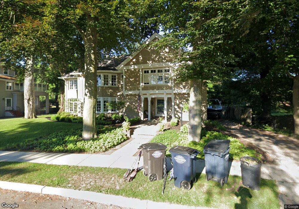
345 University Place Unit Bldg-Unit Grosse Pointe, MI 48230
Estimated Value: $1,014,000 - $1,433,000
Studio
5
Baths
4,953
Sq Ft
$232/Sq Ft
Est. Value
About This Home
This home is located at 345 University Place Unit Bldg-Unit, Grosse Pointe, MI 48230 and is currently estimated at $1,151,123, approximately $232 per square foot. 345 University Place Unit Bldg-Unit is a home located in Wayne County with nearby schools including Lewis Maire Elementary School, Pierce Middle School, and Grosse Pointe South High School.
Ownership History
Date
Name
Owned For
Owner Type
Purchase Details
Closed on
Jun 4, 2018
Sold by
Halaal Investments Inc
Bought by
Linnell Richard
Current Estimated Value
Purchase Details
Closed on
Jan 5, 2018
Sold by
Us Bank National Association
Bought by
Halaal Investments Inc
Purchase Details
Closed on
Dec 3, 2015
Sold by
Knowlton Stephen
Bought by
U S Bank National Association
Purchase Details
Closed on
Nov 24, 2004
Sold by
Grady Knowlton Kathleen Ann and Grady Kathleen Ann
Bought by
Knowlton Ii G Stephen
Create a Home Valuation Report for This Property
The Home Valuation Report is an in-depth analysis detailing your home's value as well as a comparison with similar homes in the area
Home Values in the Area
Average Home Value in this Area
Purchase History
We collect this data history from publicly available records. To have your information removed, we recommend requesting removal directly through your county’s website.
| Date | Buyer | Sale Price | Title Company |
|---|---|---|---|
| Linnell Richard | $650,000 | Title Connect Llc | |
| Halaal Investments Inc | $469,350 | None Available | |
| U S Bank National Association | $762,955 | Attorney | |
| Knowlton Ii G Stephen | -- | Title Plus Llc |
Source: Public Records
Tax History
| Year | Tax Paid | Tax Assessment Tax Assessment Total Assessment is a certain percentage of the fair market value that is determined by local assessors to be the total taxable value of land and additions on the property. | Land | Improvement |
|---|---|---|---|---|
| 2025 | $13,384 | $549,300 | $0 | $0 |
| 2024 | $12,934 | $459,200 | $0 | $0 |
| 2023 | $12,335 | $363,700 | $0 | $0 |
| 2022 | $17,852 | $364,100 | $0 | $0 |
| 2021 | $16,927 | $337,000 | $0 | $0 |
| 2019 | $18,116 | $333,100 | $0 | $0 |
| 2018 | $7,219 | $324,300 | $0 | $0 |
| 2017 | $12,541 | $320,400 | $0 | $0 |
| 2016 | $10,864 | $315,600 | $0 | $0 |
| 2015 | $20,601 | $293,400 | $0 | $0 |
| 2013 | $19,958 | $216,100 | $0 | $0 |
| 2012 | -- | $194,900 | $0 | $0 |
Source: Public Records
Map
Nearby Homes
- 334 University Place
- 377 Rivard Blvd Unit 3
- 393 Lakeland St
- 387 Neff Rd
- 296 Rivard Blvd
- 451 Saint Clair Ave
- 277 Lincoln Rd
- 355 Lincoln Rd
- 516 Neff Ln
- 17680 E Jefferson Ave
- 386 Notre Dame St
- 513 Saint Clair Ave
- 11 Wellington Place
- 29 Fisher Rd
- 234 Lincoln Rd
- 50 Cranford Ln
- 42 Cranford Ln
- 25 Village Ln
- 4 Elmsleigh Ln
- 16904 Saint Paul St
- 345 University Place
- 372 Lakeland St
- 356 Lakeland St
- 333 University Place
- 365 University Place
- 365 University Place
- 348 Lakeland St
- 17330 Maumee Ave
- 325 University Place
- 344 University Place
- 354 University Place
- 369 University Place
- 382 Lakeland St
- 364 University Place
- 357 Rivard Blvd
- 363 Lakeland St
- 340 Lakeland St
- 361 Rivard Blvd
- 365 Rivard Blvd
- 355 Lakeland St
Your Personal Tour Guide
Ask me questions while you tour the home.