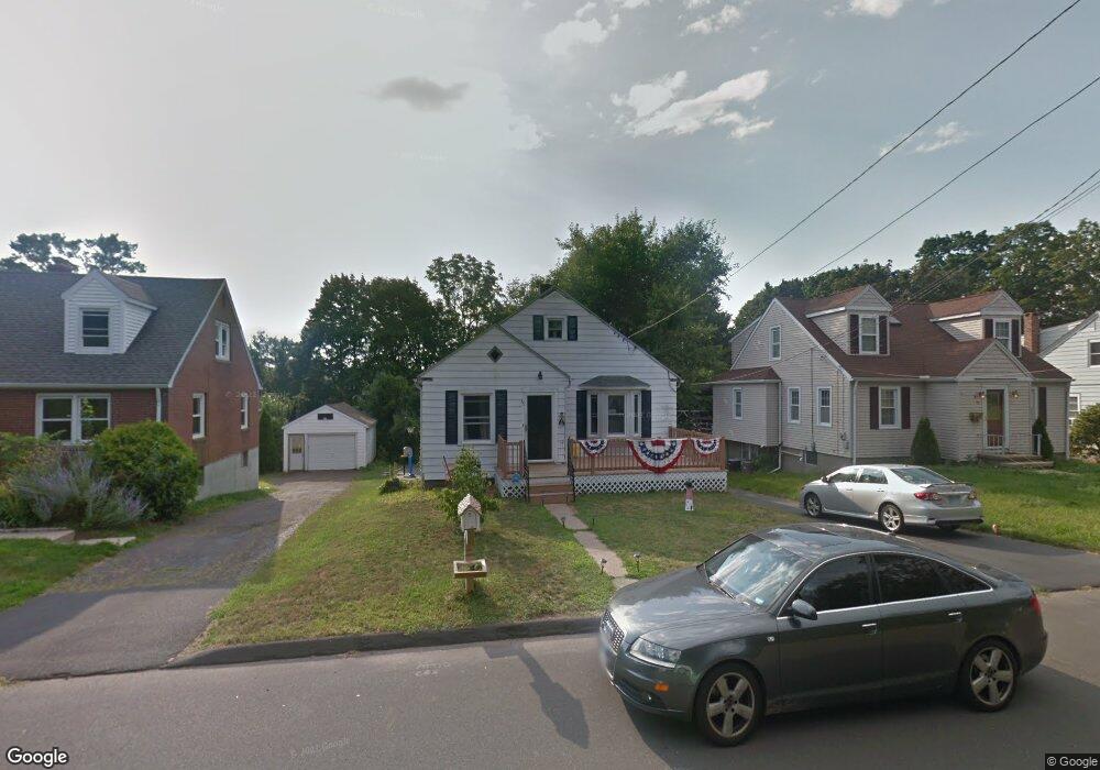
35 Draper Ave Meriden, CT 06450
Estimated Value: $277,000 - $459,000
3
Beds
2
Baths
966
Sq Ft
$341/Sq Ft
Est. Value
About This Home
This home is located at 35 Draper Ave, Meriden, CT 06450 and is currently estimated at $329,026, approximately $340 per square foot. 35 Draper Ave is a home located in New Haven County with nearby schools including Casimir Pulaski School, Washington Middle School, and Francis T. Maloney High School.
Ownership History
Date
Name
Owned For
Owner Type
Purchase Details
Closed on
Nov 22, 1993
Sold by
Alfonso Jose R and Alfonso Haydee L
Bought by
Alier Emilio and Alier Nancy M
Current Estimated Value
Home Financials for this Owner
Home Financials are based on the most recent Mortgage that was taken out on this home.
Original Mortgage
$112,100
Interest Rate
6.77%
Mortgage Type
Unknown
Purchase Details
Closed on
Jan 29, 1988
Sold by
R & A Enterprises
Bought by
Alfonso Jose R
Home Financials for this Owner
Home Financials are based on the most recent Mortgage that was taken out on this home.
Original Mortgage
$93,750
Interest Rate
10.65%
Purchase Details
Closed on
Jun 30, 1987
Sold by
Charnysh Evelyn A
Bought by
R&A Enterprises
Create a Home Valuation Report for This Property
The Home Valuation Report is an in-depth analysis detailing your home's value as well as a comparison with similar homes in the area
Home Values in the Area
Average Home Value in this Area
Purchase History
We collect this data history from publicly available records. To have your information removed, we recommend requesting removal directly through your county’s website.
| Date | Buyer | Sale Price | Title Company |
|---|---|---|---|
| Alier Emilio | $118,000 | -- | |
| Alfonso Jose R | $125,000 | -- | |
| R&A Enterprises | $113,000 | -- |
Source: Public Records
Mortgage History
We collect this data history from publicly available records. To have your information removed, we recommend requesting removal directly through your county’s website.
| Date | Status | Borrower | Loan Amount |
|---|---|---|---|
| Closed | R&A Enterprises | $9,668 | |
| Closed | R&A Enterprises | $112,100 | |
| Previous Owner | R&A Enterprises | $93,750 |
Source: Public Records
Tax History
| Year | Tax Paid | Tax Assessment Tax Assessment Total Assessment is a certain percentage of the fair market value that is determined by local assessors to be the total taxable value of land and additions on the property. | Land | Improvement |
|---|---|---|---|---|
| 2025 | $4,803 | $119,770 | $51,940 | $67,830 |
| 2024 | $4,349 | $119,770 | $51,940 | $67,830 |
| 2023 | $4,167 | $119,770 | $51,940 | $67,830 |
| 2022 | $3,951 | $119,770 | $51,940 | $67,830 |
| 2021 | $3,647 | $89,250 | $41,020 | $48,230 |
| 2020 | $3,647 | $89,250 | $41,020 | $48,230 |
| 2019 | $3,647 | $89,250 | $41,020 | $48,230 |
| 2018 | $3,663 | $89,250 | $41,020 | $48,230 |
| 2017 | $3,563 | $89,250 | $41,020 | $48,230 |
| 2016 | $4,113 | $112,280 | $48,440 | $63,840 |
| 2015 | $4,113 | $112,280 | $48,440 | $63,840 |
| 2014 | $4,013 | $112,280 | $48,440 | $63,840 |
Source: Public Records
Map
Nearby Homes
- 19 Draper Ave
- 61 Ridgefield St
- 34 Stanley St
- 219 S Broad St Unit S107
- 104 Gale Ave
- 73 Lanouette Street Extension
- 85 Lanouette Street Extension
- 71 Broad St
- 203 Spring St
- 111 Ione Dr
- 326 Cook Ave
- 161 Spring St
- 46 Meriden Ave
- 151 View St
- 16 Winthrop St
- 181 Parkview St
- 147 View St
- 144 View St
- 223 Broad St
- 88 Avery Ave
Your Personal Tour Guide
Ask me questions while you tour the home.